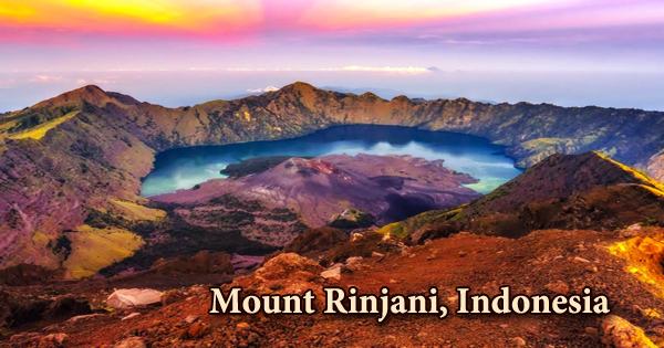
Mount Rinjani (Indonesian: Gunung Rinjani) is an active volcano that occupies the bulk of Lombok’s island. Rinjani is Indonesia’s second-highest volcano, behind Mount Kerinci in Sumatra, at 3,726 meters, and it dominates the scenery of the comparatively small island of Lombok. It’s also the highest point in Indonesia’s West Nusa Tenggara province. The crater lake Segara Anak is located within the caldera’s massive 50-square-kilometer caldera (Child of the Sea). Within the caldera, eruptive activity has created a new tiny cone known as Gunung Baru (New Mountain).
A 6-by-8.5-kilometer (3.7-by-5.3-mile) caldera adjacent to the volcano is partially filled by the crater lake known as Segara Anak or Anak Laut (Child of the Sea) because to the color of its water, which is as blue as the sea (laut). Mount Rinjani National Park (Taman Nasional Gunung Rinjani) is made up of the peak and its satellites, which spans 41,000 hectares within the park’s boundaries and another 66,000 hectares of protected forest on the outskirts. The caldera features hot springs and is around 2,000 meters (6,600 feet) above sea level. The lake is roughly 200 meters (660 feet) deep.
Mount Rinjani was submitted as one of the world’s official geoparks by the Indonesian government to UNESCO in 2008. Mount Rinjani would become Indonesia’s first geological park if it was authorized by UNESCO. The trek to the top isn’t easy, but it’s well worth it, and the view from the summit is usually recognized as one of the best in the country. Rinjani is one of at least 129 active volcanoes in Indonesia, four of which are part of the Sunda Arc trench system, which is part of the Pacific Ring of Fire, which stretches from the Western Hemisphere to Japan and Southeast Asia.
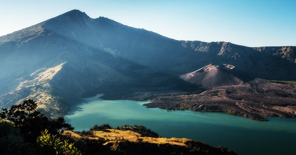
A crescent-shaped lake, the magnificent Segara Anak, is located within the mountain and is a spiritual site. Every year, the Balinese come here to perform a rite in honor of the mountain spirit. The Sunda Arc’s center region includes the islands of Lombok and Sumbawa. Some of the world’s most deadly and explosive volcanoes may be found in the Sunda Arc. The highlands are primarily underdeveloped and covered in forest. The lowlands are heavily farmed. Rice, soybeans, coffee, tobacco, cotton, cinnamon, cacao, cloves, cassava, corn, coconuts, copra, bananas, and vanilla are some of the most important crops farmed on the island’s fertile soils.
Rinjani is most commonly climbed as part of a four- or five-day hiking adventure that begins in Senaru and ends in Sembalun Lawang. Trekkers begin their journey from Senaru, hiking to the beautiful crater rim, then down to the amazing crater lake, and finally to Sembalun Lawang. The Rinjani volcano on the island of Lombok rises to 3,726 meters (12,224 feet), second only to Sumatra’s Kerinci volcano in terms of height among Indonesian volcanoes. The first known historical eruption occurred in 1847; prior to then, this was a relatively distant region, which explains the absence of records.
Rinjani’s volcano rises 165–190 kilometers (103–118 miles) above the Benioff Zone. Between the most easterly Sumbawa volcano (Sangeang Api) and the line of active volcanoes in Flores, there is a significant offset in the line of active volcanoes. Between 1994 and 1995, there was a burst of activity that resulted in the crater cone Gunung Baru, which has since been renamed Gunung Barujari, growing even more (Finger Mountain). Gunung Barujari reopened to the public on April 27, 2009, and remained operational till May 2009.
The Center for Volcanology & Geological Hazard Mitigation, Indonesia, placed Gunung Rinjani on standby in May 2010, recommending that no activity occur within a 4-kilometer (2.5-mile) radius of the eruption of Gunung Barujari. Lava erupted into the caldera lake, raising the temperature from 21°C to 35°C and spreading smoke for 12 kilometers. During any of the eruptive activity in early 2010, the volcano did not pose a direct threat to residents, though access to some parts of the mountain was limited or restricted at times.
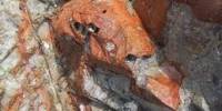
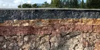
Rinjani volcano is located on the island of Lombok, around 300 kilometers (190 miles) north of the Sunda Trench (also known as Java Trench) and 170 kilometers (110 miles) above the active north dipping Benioff zone. The mountain’s lower and middle levels are densely wooded. The slopes are desolate and craggy scree slopes and volcanic rock above the tree line. The sunrise and views of the crater lake from the caldera rim are both breathtaking. Ankaramite, high-Al basalt, andesite, high-K andesite, and dacite are only a few of the lavas found in Rinjani.
Because Lombok is east of the Wallace Line, it has a number of bird species with Australasian connections. Honeyeaters, cockatoos, and green hanging parrots are among them, as are tits, weavers, and tailor-birds, which have their heartlands in the West. Mount Rinjani received the World Legacy Award from Conservation International and Traveller (2004), and was a nominee for the World Travel Tourism Council’s (WTTC) Tourism for Tomorrow Awards in 2005 and 2008.
The villages of Senaru and Sembalun Lawang are the two starting places for climbing Gunung Rinjani. Senaru Village is located three hours north of Mataram, and Sembalun Lawang Village is located four hours east of Mataram. The Gunung Rinjani National Park, which was formed in 1997, protects the volcano and crater. Tourism is growing in popularity, with hikers able to explore the rim, enter the caldera, or even attempt the more difficult climb to the summit; however, fatalities are not uncommon.
Information Sources: