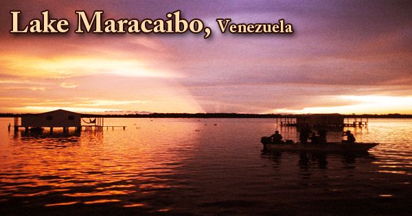
Lake Maracaibo (Spanish: Lago de Maracaibo, pronounced: ˈlaɣo ðe maɾaˈkajβo) situated in the Maracaibo Basin of northwest Venezuela, and it is a large inlet of the Caribbean Sea. In Venezuela, it is a large brackish tidal bay (or tidal estuary). Rather than a bay or lagoon, it is often called a pool. It is linked to the Gulf of Venezuela by the Strait of Tablazo, which, at the northern end, is 5.5 kilometers (3.4 mi) deep. Numerous rivers feed it, the largest being the Catatumbo. Some reports consider the water body to be South America’s largest natural lake, covering an area of around 5,130 square miles (13,280 square km), stretching southward from the Gulf of Venezuela for 130 miles (210 km) and reaching a width of 75 miles (121 km).
Lake Maracaibo
It was once the largest lake in South America at 13,210 square kilometers (5,100 sq mi); the historical record indicates that it was a true lake in the past, and as such, at 20-36 million years old, is one of the oldest lakes on Earth. However, some sources mention that Lake Maracaibo is more accurately referred to as an inlet since the tide from the Atlantic Ocean carries in all of the water it receives. In northern South America, one tiny region is obviously the largest lightning hotspot in the country. The hotspot is situated in northwestern Venezuela, above the southern end of Lake Maracaibo, a brackish bay. The lightning flash intensity density of this area is 232.52. That means an average of 232.52 flashes of lightning per square kilometer per year are experienced in the city.
The Catatumbo River, a transport artery for goods from the neighboring regions and from the Colombian-Venezuelan highlands, is the most important one. Several rivers flow into Lake Maracaibo. The lake water in the southern portion is fresh, but the northern waters are more brackish because of a stronger tidal influence. Maracaibo Lake serves as a major shipping route to Maracaibo and Cabimas ports. One of the longest bridges in the world is the 8.7-kilometer (5.4 mi) long General En Jefe Rafael Urdaneta Bridge, which was completed in 1962 and spans the bay’s outlet. The lake, except towards the south, is very shallow and is surrounded by swampy lowlands.
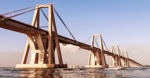
View of General Rafael Urdaneta Bridge
Besides Venezuela and the Democratic Republic of the Congo, the world’s top ten lightning hotspots include sites in Colombia, Pakistan, and Cameroon. A bar at the mouth of the lake, spanning some 16 miles (26 km) for several years, limited navigation to vessels with water of less than 13 feet (4 meters). The depth increased to 25 feet (8 meters), a 2-mile (3-km) long stone breakwater, and a 35 foot (11-metre) deep channel were completed in 1957 after continuous dredging in the 1930s to accommodate oceangoing ships and tankers. In the south and south-west, specifically at Lagunetas, there are still many settlements established on stilts over the lake palafitos.
Lake Maracaibo has a reputation, dating back to the beginning of written history, for its lightning. This phenomenon is named ‘Relámpago del Catatumbo’ by local people (Catatumbo lightning). It is named after the River Catatumbo, which, on its southern shore, joins Maracaibo Bay. The lightning is concentrated above the river’s mouth. Some oil-producing areas adjacent to Lake Maracaibo have sunk because of a large amount of oil removed in the Maracaibo Basin, changing the region’s geography. The construction of the dike structures has fallen to the Venezuelan government after the nationalization of the oil industry in 1976 to shield subsea-level areas such as Tía Juana, Lagunillas, and Bachaquero from invasion by the waters. Cumulative subsidence is as much as 5 meters (16 ft), and at certain places inland and usually 5 cm/year (2.0 in/year) along the coast, it occurs at a rate of up to 20 centimeters per year (7.9 in/year).
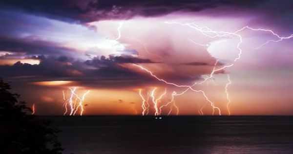
Lightning hotspot over Lake Maracaibo
One of the richest and most centrally situated petroleum-producing areas in the world is Lake Maracaibo. The first productive well was drilled in 1917, and a 65-mile (105-km) strip along the eastern shore, reaching 20 miles (32 km) out into the lake, has come to include the productive area. Although underwater pipelines carry the oil to storage tanks on the ground, thousands of derricks protrude from the water, and many more line the shore. The lake’s waters are very warm all year long, generally between 28 and 31 degrees Celsius (82 to 88 degrees Fahrenheit). To push convection, this makes the lake a ready source of heat and humidity.
Information Sources: