The Mekong Delta region in Southeast Asia is likely to experience increased frequency and severity of flooding due to a combination of factors including climate change, dam construction upstream, and land subsidence caused by excessive groundwater extraction.
The Mekong River Delta is the agricultural heartland of Vietnam; it is affected by droughts and flooding, which have become more severe in recent years. Risk assessments in the regions can be enhanced if severe weather occurrences can be predicted more precisely. In turn, this will lessen the region’s exposure to the damaging effects of droughts and floods.
A team led by Tsuyoshi Watanabe at Hokkaido University has revealed the clearest picture yet of how the El Niño Southern Oscillation (ENSO) affected rainfall in the Mekong Delta over the last hundred years.
Their findings were published in the journal Scientific Reports. They discovered that the ENSO has generated seasons of heavy and light rainfall, resulting in patterns of both flooding and droughts, by correlating water salinity data from reef coral samples with historical meteorological records.
The ENSO occurs in the central and Eastern tropical Pacific ocean, in irregular cycles of two to seven years. It consists of the El Niño (warming of the ocean surface), La Niña (cooling of the ocean surface) and neutral (neither warming, nor cooling).
“We found that heavy rains and flooding have become more severe in recent years, driven by changes in the ENSO due to global warming,” said Watanabe, corresponding author of the study. “The Mekong River Delta will continue to be faced with a higher risk of severe flooding.”
El Niño and La Niña have significant effects on weather patterns and extreme weather events in these regions. Understanding the weather patterns caused by ENSO in the Mekong River Delta (MRD) is critical to ensuring a stable food supply.
Reef corals have growth rings, similar to trees. These rings preserve a record of the salinity of the surrounding water in each year. The reef coral we sampled was on Con Dao Island, close to the MRD; as a result, the salinity records can be associated with increased or decreased rainfall in the MRD and hence with flooding or droughts.
Tsuyoshi Watanabe
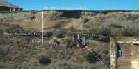
On Con Dao Island, 90 kilometers south of the MRD, the group led by Watanabe made the discovery of a reef coral. They were able to determine monthly variations in the salinity of the surrounding water from a core sample of this coral.
“Reef corals have growth rings, similar to trees,” says Watanabe. “These rings preserve a record of the salinity of the surrounding water in each year. The reef coral we sampled was on Con Dao Island, close to the MRD; as a result, the salinity records can be associated with increased or decreased rainfall in the MRD and hence with flooding or droughts.”
Combining the salinity data with historical annual rainfall maximums allowed the team to extend rainfall data back to 1924.
Analysis of this rainfall data showed that the hydrological changes in the MRD are affected by El Niño and La Niña in the Central Pacific Ocean associated with light rain and heavy rain in the MRD respectively.
In particular, heavy rain in the MRD is strongly associated with La Niña in the recent past, while the association between light rain and El Niño have been consistent during the last century.
Future weather forecasts will be more precise thanks to our improved understanding of how the ENSO affects the Mekong River Delta. Additionally, this should make it possible to better prepare for harsh weather conditions, enhancing both population safety and food security.
This press release is dedicated to the memory of Dr. Tung Thanh Phan, co-first author, who unexpectedly passed away on October 28, 2022. This study is partially based on the results of his doctoral research.