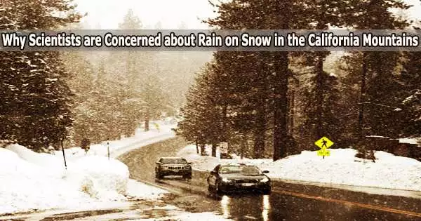
Following storms that poured record-breaking amounts of snow in January and February 2023, California is currently experiencing another round of severe atmospheric rivers. This time, the storms are warmer, and they are bringing rain higher into the mountains on top of the snowpack, causing flood warnings.
Professor Keith Musselman, who studies water and climate change at the University of Colorado’s Institute of Arctic and Alpine Research, explained the complex risks rain on snow creates and how they might change in a warming climate.
What happens when rain falls on snowpack?
Storms with a lot of rain can happen in parts of the United States that have a seasonal snow cover. When that occurs, there may be a substantially larger flow of water than would otherwise arise from rain or snowmelt. The combination has caused some of the most expensive and damaging floods in American history, including the 2017 flood that devastated California’s Oroville Dam and the 1996 Midwest floods.
Contrary to popular perception, snow cannot be completely melted by rains. Instead, the factors that most influence snowmelt during rain-on-snow occurrences are warm temperatures, strong winds, and high humidity, which can carry significant energy in the form of latent and sensible heat.
Air voids in snowpack allow water to pass through. Rainfall can move quite quickly through the layers of the snowpack to the underlying soil. Depending on how much water is already flowing and how saturated the earth is, streams will react differently to the runoff.
By absorbing rain and melting snow when the soil isn’t quite saturated, it might attenuate or delay a flood response. Yet, when the earth is already wet, snowmelt and rain can quickly and severely flood an area.
One of the challenges for dealing with these rain-on-snow events is that the flood risk is hard to forecast.
Understanding the weather and hydrological conditions is necessary to forecast whether a flood may occur. It necessitates knowledge of the snowpack and soil moisture levels prior to the storm, as well as the elevation at which rain turns to snow, the rate of precipitation, the wind speed, the air temperature, and humidity, and estimations of the contributions of each of these variables to melting.
Additionally, each factor varies in time during a storm and varies in complex ways, especially across a mountainous landscape.
This is why rain-on-snow floods are characterized as compound extreme events. Despite the extensive damage they can cause, it may be surprising how little is known about how they vary in time, spatial extent and intensity.
California is getting another atmospheric river, with more rain on snow expected. How does the rain-on-snow effect differ by elevation in the mountains there?
In the California mountains right now, it’s the middle elevations that people need to pay attention to.
The lower elevations have primarily seen rainfall rather than snow, so there is less snowpack to melt. And in the highest elevations, colder temperatures promote the continued accumulation of deep snowpack and rainfall is less likely.
Rain-on-snow events are most frequent in the middle of the transition zone, when either significant snowfall or rainfall may occur, melting the snow and increasing the danger of roof collapses.
If all storms were formed equally, there would be well defined snow and rain zones, and the risk of flooding from rain on snow would be minimal. But it doesn’t really work like that. Instead, the snow zone elevation varies significantly not only from one storm to the next, but also during an event.
The most destructive rain-on-snow events occur when rivers are already running high and soils are saturated, which can occur in response to a series of warm atmospheric rivers interacting with a deep snowpack like California’s mountains have right now.
The order in which these storms occur or the storm sequencing is especially important for assessing flood risk because these events are, in part, caused by rapid shifts between cold periods of snow accumulation followed by warm rainfall events.
What does research show about the future risk of rain-on-snow events in a warming climate?
Even less is known about how rain-on-snow flood risk may respond as the planet warms.
In a warmer climate, there will be less risk of rain falling on snow in the lower elevations as the snowpack declines, particularly in warmer regions such as the Pacific Northwest.
But at higher elevations, more frequent rain-on-snow events are expected. While warmer temperatures are expected to increase rainfall intensity, research shows that’s not the most important driver of this risk.
The expansion of the rain-snow transition zone higher in elevation to include alpine regions that historically received only snowfall is largely responsible for the anticipated increase in the risk of rain-on-snow floods.
To properly comprehend and be ready for the local flood risk as the world warms, flood control and reservoir management systems in these mountainous locations will need to take into account these future changes in rain-on-snow events in addition to changes in rainfall intensity and storm sequencing.
So, will projected increases in precipitation extremes and winter rainfall increase rain-on-snow occurrence and the associated flood risk? Or will less snow cover and larger soil moisture deficits reduce rain-on-snow flood risk in a warmer climate?
The reaction of rain-on-snow flood danger is anticipated to evolve in a complex and frequently conflicting manner in a future climate. Depending on the place, season, climate model, emissions scenario, and long-term time horizon, the expected changes may differ. It’s a costly risk that requires more research.