Researchers at Flinders University have employed airborne surveys and sub-surface imaging to peer into floodplains in West Arnhem Land’s Red Lily Lagoon region, northern Australia.
These innovative techniques demonstrated how the Northern Territory’s significant landscape was changed by the rise in sea levels some 8,000 years ago.
Their discovery demonstrates that the ocean has reached this area, which is now inland, and has significant ramifications for comprehending Madjedbebe, the earliest archaeological site in Australia.
The discoveries also offer a fresh perspective on the local rock art, which is renowned throughout the world for its importance and unique aesthetic.
The researchers can identify how the metamorphosis of Red Lily Lagoon has led to the creation of mangroves that have supported animal and marine life in a place where ancient Indigenous rock art is situated by analysing how sediments now buried beneath the flood plains changed as sea levels rose. The subjects and animals in the ancient rock art were inspired by this transition, which in turn helped to create an environment.
In their findings published in in the scientific journal PLOS ONE today, the researchers say environmental changes at the lagoon are reflected in the rock art because fish, crocodiles and birds were featured in the art when the floodplain transformed to support freshwater habitats for new species.
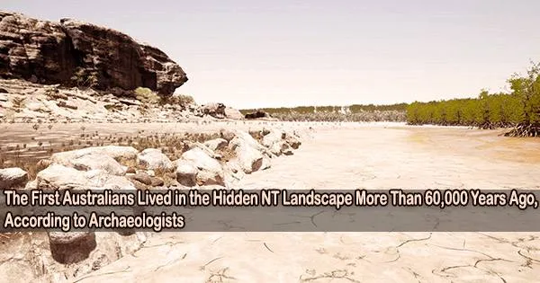
Red Lily Lagoon has exceptional archaeological significance in Arnhem Land as it is situated at one of the easternmost points of the East Alligator River floodplain, where the modern river, the Arnhem Plateau, creates a significant boundary between the low-lying floodplains and the sandstone highlands, which have been occupied by humans for over 60,000 years and are the location of countless significant sites, including some of the most iconic rock art panels in Australia.
Professor Ian Moffat
Senior Author and Research Associate in the College of Humanities, Arts, and Social Sciences at Flinders University, Dr. Jarrad Knowlessar, says the mapping fundamentally changes our archaeological understanding of the stunning landscape in Arnhem Land.
“This is a key landscape for understanding the early human occupation of Australia. Our reconstruction of Red Lily Lagoon enables effective predictive modelling of prominent cultural sites and provides an important method to interpret the presence and provenance of Indigenous cultural material.”
“The timing of rock art aligns with the broader environmental changes we understand took place in this landscape. This is evident through changes in subject matter in the art, such as large macropods, and the appearance of estuarine animal species such as fish and crocodiles in the art. The inclusion of freshwater species, such as fish and birds, occurs in the most recent artistic styles of this region, and this reflects the phases of environmental change when the freshwater floodplains made up the landscape.”
“Based on the results of this study, all Pleistocene sites in western Arnhem Land were near the ocean and, subsequently, mangrove swamps at some point during the transformation of the landscape. This has important implications for the paleogeographic settings of these sites, which must be considered when interpreting changes in stone artefacts, food resources, and the isotope composition of materials from this period of the first Australians.”
Co-author, Associate Professor Ian Moffat, says Electric Resistivity Tomography (ERT) is a rapid, low-cost, non-invasive method that can map large areas of the Australian landscape to better understand their ancient history.
“We are showcasing how ERT data can be used to develop landscape models that are useful when it comes to understanding known locations as well as predicting where buried archaeological sites might be. We have demonstrated that the landscapes of this region can be effectively mapped using non-invasive methods. This has important implications for locating new sites but also for developing a more nuanced understanding of the regional geography, and its impact on past human behaviour.”
“Red Lily Lagoon has exceptional archaeological significance in Arnhem Land as it is situated at one of the easternmost points of the East Alligator River floodplain, where the modern river, the Arnhem Plateau, creates a significant boundary between the low-lying floodplains and the sandstone highlands, which have been occupied by humans for over 60,000 years and are the location of countless significant sites, including some of the most iconic rock art panels in Australia.”
Traditional owner and co-author Alfred Nayinggull described the importance of this research as “We want people to see and want people to know what’s been happening many thousand years ago in the past.”