Flood monitoring using satellite data allows for a quick and accurate overview of flooded areas. The extent of the flooding and affected areas can be delivered to water authorities, civil protection agencies, or insurance companies. Evaluations include information to help with damage assessment, risk estimation in the future, and protection measures.
The University of Queensland researchers used radar imaging sensors on satellites to see through clouds and map flooding, and they believe the technique could provide faster, more detailed information to keep communities safe.
According to Professor Noam Levin of the University of Queensland’s School of Earth and Environmental Sciences, the project combined images from optical satellites with data from imaging radar satellites. “Monitoring floods in towns and cities is difficult because flood waters frequently rise and then recede in a matter of days,” Professor Levin said.
We could see which areas became dark as the flood waters encroached. We compared this to data from Bureau of Meteorology river gauges and changes in electricity loads reported by Energex, the power supplier.
Professor Levin
“While large satellites in the past provided images every 7-14 days, now groups of small satellites can collect several images a day over the same location. Radar imaging sensors can provide images at night or on days with thick cloud cover—a huge advantage in stormy conditions. They use a flash, like on a camera, and the light is sent at wavelengths between 1mm and 1.0m, which can pass through clouds and smoke.”
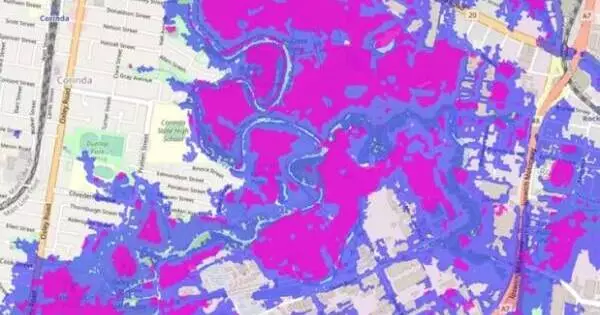
During Brisbane’s February 2022 floods, researchers combined satellite daytime pictures showing the extent of the flood with imaging radar and optical night-time data of the lights associated with human activity.
“We could see which areas became dark as the flood waters encroached,” Professor Levin said.
“We compared this to data from Bureau of Meteorology river gauges and changes in electricity loads reported by Energex, the power supplier.”
According to Professor Stuart Phinn, the technique could be critical in protecting Australians during future flooding events. “Satellites, in conjunction with existing flood monitoring and modeling technologies, could change the way we monitor major flood events, understand how they occur, and direct emergency and other responses,” Professor Phinn explained.
“Agencies monitoring the floods can assess changes and alert people in at-risk areas with faster update times—at least twice a day—and more accurate and timely data. This technique can also be used after a disaster to determine the extent of damage, direct recovery efforts, and evaluate insurance claims.”
The team used optical satellites from Planet Inc. and NASA’s VIIRS, as well as Capella imaging radar satellites.