Introduction
Bangladesh as a vacation land has many facets. Her tourist attractions include archaeological sites, historic mosques and monuments, resorts, beaches, picnic spots, forest and wildlife. Bangladesh offers opportunities for angling, water-skiing, river cruising, hiking, rowing, surfing, yachting and sea bathing as well as bringing one in close touch with Mother Nature. She is also rich in wildlife and game birds.
HISTORY
The history of Bangladesh has been one of extremes, of turmoil and peace, prosperity and destitution. It has thrived under the glow of cultural spiendour and suffered under the ravages of war. The earliest mention of Bangladesh is found in the Hindu epic, the Mahabharata (the story of Great Battle-9th century B.C). Evidence also suggests that there was a strong Mongoloid presence as well. Soon after, in the 5th and 6th centuries B.C. came the Aryans from Central Asia and the Dravidians from Western India. Then came the Guptas, Palas, Senas, who were Buddhist and Hindus.
From the 13th century A.D. the flood of Muslim invaders and the tide of Islam swamped the Buddhist and Hindus untold 8th century. Sometimes there were independent rulers like the Hussain Shahi and Ilyas Shahi dynasties while at other times they ruled on behalf of the imperial seat of Delhi. From 15th century the Europeans, namely; Portuguese, Dutch, French and British traders exerted an economic influence over the region. British political rule over the region began in 1757 A.D. when the last Muslim ruler of Ben. gal was defeated at Palassey. In 1947 the country was partitioned into India and Pakistan. Present Bangladesh becomes the Eastern Wing of the then Pakistan. But the movement for autonomy for East
Pakistan started within a couple of years because of language and cultural difference and economic disparity between the two wings. The seeds of independence were sown through the Language Movement of 1952 to recognize Bangla as a state language. Ultimately the then East Pakistan emerged as a sovereign and independent state of Bangladesh in 1971 after nine month – long war of Liberation (starting on 26 March 1971) in which 3 million people courted martyrdom.
Location and Physical features
Bangladesh is situated in the north-eastern part of south Asia. It lies between 20′ 34′ and 2e 36′ north latitude and 88′ I’ and 92′ 41′ east longitude. The heary and great Himalayas stand as the northen ramparts, while the southern frontier is guarded by the Bay of Bengal. On the west lies the expansive gangetic plains (West Bengal) of India and on the eastern frontier lies the almost impassable forest of Myanmar (Arakan Province) and India (Tripura and Assam hills). These picturesque geographical boundaries delineate out a low lying plain of about 144,000 sq.km. (55,598 sq. miles) criss -crossed by innumerable brooks, rivers, rivulets and streams. Mighty rivers the Padma, Jamuna, Meghna, Karnaphuli and others flow through Bangladesh. The unscalable blue is stretched high above, and the green and silvery landscape below runs far and beyond. This is Bangladesh, a fertile land where nature is bounteous.
Bangladesh is a deltaic region. Much of the country’s land area has been built up from alluvial deposits brought down by the major rivers. The land is mostly flat except for a range of hills in the south-east. Wooded marshylands and jungles mainly characterize it with forest regions in Sylhet, Rangamati, Khagrachari and Bandarban Hill Tracts, Sundarbans, Mymensingh and Tangail.
Place
Bangladesh is a land of scenic beauty. The country is blessed with natural beauty which attracts the tourists. It has beautiful beaches as well as the longest beach in the world. It is proud of its beautiful heritage and historical relics. To make best use of the natural gift, the country has developed facilities of modern hotels, motels, rest houses, youth inns and restaurants, as well
as modern modes of communication, are available at all tourist attractions. Some of the better known spots are: Dhaka – The City of Mosques; Chittagong – Gateway to the Bay of Bengal; Cox’s Bazar – The Tourist Capital; Rangamati – The Heart of the Lake District; Kaptai – The Lake Town, Sylhet – Land of Two Leaves and a Bud; Sundarban– Home of the Royal Bengal Tiger;
Bandarban – The Hilly Resort; Kuakata – Where the Sun Rises and Sets in the Sea; Mainamati – Seat of Lost Dynasties; Mahasthangarh – The Ancient Seat of Buddhist Rule; Rajshahi – The Silk Producing Centre; Natore – Place of Dighapatiay Palace: Paharpur – The Seat of Buddhist Learning; Dinajpur – Old Ornamental Temple Town; and Mymensing – The Heart of Bengal’s Folklore. Bangladesh Parjatan Corporation (BPC) is an autonomous government organization that caters to the needs of local and foreign tourists. BPC has tourist facilities at Dhaka, Cox’s Bazar, Chittagong, Rangpur, Rangamati, Rashahi, Bogra, Finajpur, Kuakata, Sylhet and Sundarban. It organizes package tours, sightseeing trips and excursions. A number of private
sector tour operators are also active in the country.
Beach Area
Cox’s Bazar
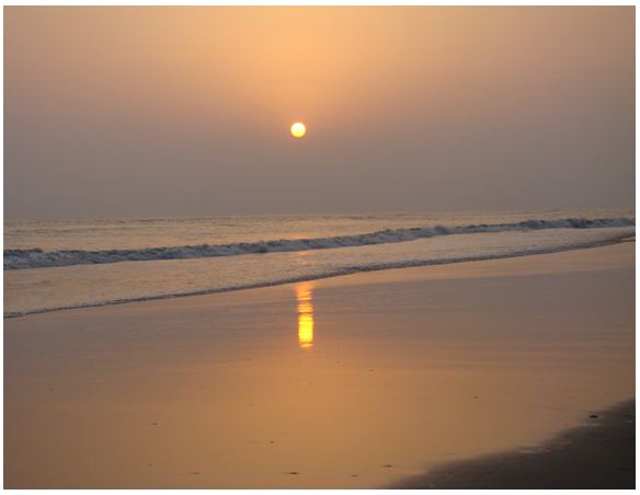
Miles of golden sands, towering cliffs, surfing waves, rare conch shells, colorful Pagodas, Buddhist Temples and delightful sea-food – all this makes what Cox’s Bazar is today , the tourist capital of Bangladesh. The World’s longest uninterrupted (120 km.) beach slopes here down to the blue waters of the Bay of Bengal against the picturesque background of a chain of hills covered with deep green forests.
Cox’s Bazar is one of the most attractive tourist spots in the world. The warm, shark free, waters are good for bathing and swimming & while the sandy beaches offer opportunities for sun-bathing.
The beauty of the setting-sun behind the waves of the sea is simply captivating. Locally made cigars and handloom products of the tribal Rakhyne families are good buys.
Located at a distance of 152 km. south of Chittagong, Cox’s Bazar is connected both by air and road from Dhaka and Chittagong.
Visit to the fascinating picnic spots at Himchari and Teknaf, the Buddhist Temple at Ramu and nearby islands of Sonadia and St. Martin’s, Inani Beach and Moheshkhali are certain to become unforgettable experiences for every visitor.
Inani Beach
Inani is within Ukhia Thana, 35 km. to the south of Cox’s Bazar. With green hills to the east, the golden beach of Inani casts a music spell on anyone stepping on to its fine golden sands. The clean blue waters of the Bay are ideal for swimming.
Kuakata
Kuakata, locally known as Sagar Kannya (Daughter of the Sea) is a rare scenic beauty spot on the southernmost tip of Bangladesh. Kuakata in Latachapli union under Kalapara Police Station of Patuakhali district is about 30 km in length and 6 km in breadth. It is 70 km from Patuakhali district headquarters and 320 km from Dhaka. At Kuakata excellent combination of the picturesque natural beauty, sandy beach, blue sky, huge expanse of water of the Bay and evergreen forest in really eye-catching.
The name Kuakata have originated from Kua-Well dug on the sea shore by the early Rakhine settlers in quest of collecting drinking water, who landed on Kuakata coast after explled from Arakan by Moughals. Afterwards, it has become a tradition of digging Kua-Well in the neighbourhood of Rakhaine homestead for collection water for drinking purpose and general use.
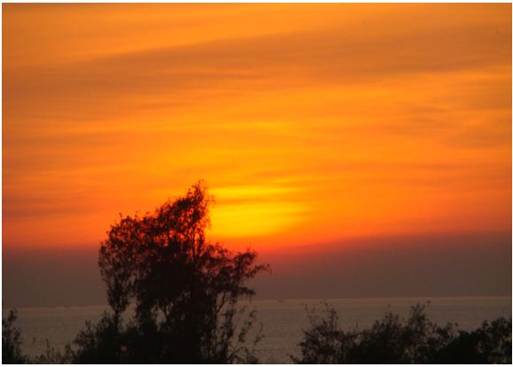
Kuakata is one of the rarest places which has the unique beauty of offering the full view of the rising and setting of crimson sun in the water of the Bay of Bengal in a calm environment. That perhaps makes kuakata one of the world’s unique beaches. The long and wide beach at Kuakata has a typical natural setting. This sandy beach has gentle slopes into the Bay of Bengal and bathing there is as pleasant as is walking or diving. Kuakata is truly a virgin beach-a sanctuary for migratory winter birds, a series of coconut trees, sandy beach of blue Bay, a feast for the eye. Forest, boats plying in the Bay of Bengal with colourful sails, fishing, towering cliffs, surfing waves everything here touches every visitor’s heart. The unique customs and costumes of the ‘Rakhyne’ tribal families and Buddhist Temple of about hundred years old indicate the ancient tradition and cultural heritage, which are objects of great pleasure Kuakata is the place of pilgrimage of the Hindus and Buddhist communities. Innumerable devotees arrive here at the festival of ‘Rush Purnima’ and ‘Maghi Purnima’. On these two days they take holy bath and traditional fairs are held here. All these additional offers to panoramic beauty make the beach more attractive to the visitors. One should visit Kuakata and discover the lovely grace of Bangladesh.
Parki Beach
Parki beach is situated in Gahira, Anwara thana under southern Chittagong region. The beach lies about 28 km. away from Chittagong city. As the beach is situated at the Karnaphuli river channel, visitors can view both the Karnaphuli river and the sea together. Tourists enjoy the views of big ships anchored at the outer anchor, fishermen catching fish in sea, sunset, various coloured crabs at the beach, and quiet environment. In picnic season, many visitors come to the beach.
Patenga Beach
The Patenga beach at Chittagong is one of the most popular beaches of Bangladesh, stretching for miles near at the meeting place of the Bay of Bengal and the river Karnaphuli. Nature lovers come around here to enjoy the scenic sunrise and sunset.
St. Martin Island
Forty-eight kilometers from Teknaf, St. Martin’s is the country’s only coral island and an unspoilt paradise. Named Narikel Jinjira (Coconut Island) by the locals, the dumbbell shaped St.Martin’s has an area of only 8 sq. km. which reduces to about 5 sq. km. and in places from 1-4 meters during high tide.
The Cox’s Bazar Holiday Complex of Bangladesh Parjatan Corporation on the island is an shore tourist resort having comfortable accommodation, catering, sightseeing and other facilities.
Sonadia Island
It is about seven kilometer of Cox’s Bazar and about nine square kilometer in area. The western side of the island is sandy and different kinds of shells are found on the beach. Off the northern part of the island, there are beds of window pane oysters. During winter, fisherman set up temporary camps on the island and dry their catches of sea fish.
Teknaf
Southernmost tip of Bangladesh, Teknaf situated on the Naaf river and just at the end of the hilly regions of the district. Mayanmar is on the opposite bank of Naaf river. Wild animals and birds are available but the most interesting thing is a journey on the river. Wide sandy beach in the backdrop of high hills with green forests is an enchanting scene never to be forgotten.
Hilly Area
Decidedly untypical of Bangladesh in topography and culture, the Chittagong Hill Tracts have steep jungle hills, Buddhist tribal peoples and relatively low density population. The tracts are about 60km (37mi) east of Chittagong. The region comprises a mass of hills, ravines and cliffs covered with dense jungle, bamboo, creepers and shrubs, and has four main valleys formed by the Karnapuli, Feni, Shangu and Matamuhur rivers
Rangamati, a lush and verdant rural area belonging to the Chakma tribe, is open to visitors, as is Kaptai Lake. The lake, ringed by thick tropical and semi-evergreen forests, looks like nothing else in Bangladesh. While the lake itself is beautiful, the thatched fishing villages located on the lakeshore are what make a visit really special. Boats that visit the villages leave from Rangamati. Bring your swimming gear because you can take a plunge anywhere.
Rangamati
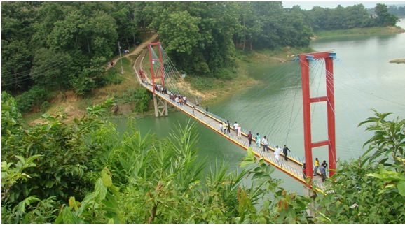
From Chittagong a 77 km road amidst green fields and winding hills will take you to Rangamati, the headquarter of Rangamati Hill District which is a wonderful repository of scenic splendours with flora and fauna of varied descriptions. The township is located on the western bank of the Kaptai lake. Rangamati is a favourite holiday resort because of its beautiful landscape, scenic beauty, lake, colourful tribes (Chakma, Marma etc)., its flora and fauna, tribal museum, hanging bridge, homespun textile products, ivory jewellery and the tribal men and women who fashion them. For tourists the attractions of Rangamati are numerous, tribal life, fishing, speed boat cruising, water skiing, hiking, bathing or merely enjoying nature as it is. Some of the Offers: Bangladesh Parjatan Corporation provides suitable hotel and cottage accommodation, catering, speed boat, paddle boat and other facilities at Rangamati.
Bandarban
Ninety-two kilometers from Chittagong by metalloid road, Bandarban is the hometown of the Bohmong Chief who is the head of the Mogh tribe. It is also the home of the Murangs who are famous for their music and dance. Several other tribes of great interest live in the remote areas of the district. The highest peak of Bangladesh – Tahjindong (4632 ft) is located in the Bandarban district.
Khagrachari
A drive of 112 km. from Chittagong, by an all weather metalloid road through the green forest brings one to the district headquarters of Khagrachari, abode of fascinating calm. For the tourists seeking nature in restful mood, Khagrachari is an ideal spot.
Madhabkunda
About 3 km. from Dakhinbagh Railway Station there is the famous waterfall of Madhabkunda which attracts large number of tourists every year.
Srimongal
Srimongal is famous for the largest tea gardens of world covered by lush green carpet. One can have a look into the spectacular tea processing at Tea Research Institute.
Tamabil-Jaflong
Situated amidst splendid panorama, Tamabil is a border outpost on Sylhet-Shilong Road about 55 km. away from Sylhet town. Besides enchanting views of the area one can also have a glimpse of the waterfalls across the border from Tamabil. Jaflong is also a scenic spot nearby amidst tea gardens and rate beauty of rolling stones from hills.
Sitakunda
It is approximately 37 km far from Chittagong city. This is famous for Chandranath Hindu Temple – one of the oldest temples in the subcontinent. There is also Buddhist Temple having a footprint of Lord Buddha. These places particularly the hilltops are regarded as very sacred by the hindus and buddhist. Shiva Chaturdashi (14th) festivals is held every year in February when thousands of pilgrims assemble which lasts for ten days. There is also a hot-water spring 5 km to the north of Sitakunda.
Historical & Archeological Places
Historically, Bangladesh has earned its reputation for being at the crossroads of many cultures. The ruins of magnificent cities and monuments left behind in various parts of the country by the vanishing dynasties of rulers still bear testimony to the richness of its cultural heritage. Scattered throughout the country are countless ancient monuments and antiquities that have survived the ravishes of natural calamities. Today they offer the visitors a glimpse into the history of this country and its rich heritage. Following is a bird’s eye view of the historical places to visit in the various districts of the Bangladesh.
Mainamati
About eight km. to the west of Comilla town which is situated 144 km. south east of Dhaka lies a range of low hills known as Mainamati-Lalmai ridge, an extensive centre of Buddhist culture. On the slopes of these hills lie scattered a treasure of information about the early Buddhist civilization (7th-12th Century A.D.) At Salban in the middle of the ridge, excavations bare a Large Buddhist Vihara (monastery) and imposing Central Sharine. It has revealed valuable information about the rule of the Chandra and Deva dynasties which flourished here from the 7th to 12th century. The whole range of hillocks run for about 18 km. and is studded with more than 50 sites. A site museum houses the archaeological findings which include terracotta plaques, bronze statues and casket, coins, jewellery, utensils, pottery and votive stupas embossed with Buddhist inscriptions. Museum is open Sunday-Friday and closed on Saturday. Bangladesh Academy for Rural Development (BARD) Established nearby in 1959 is known for its pioneering role in co-operative movement.
Dinajpur
One of the northern districts of the country Dinajpur is a repository of interesting, historical and valueable places and objects. The Ramsagar lake with rest houses is the most ideal place for picnic. This place offers many facilities for the entertainment of the visitors, among them are fishing and rowing in a serene and calm environment. The most ornate of the late medieval temples of the country
Kantanagar’ stands out near Dinajpur town. It was built by maharaja Pran nath of dinajpur in 1752. The temple is still considered the finest of its type in terracotta built by local artisans.
Ramu
This is a typical Buddhist village, about 16 km. from Cox’s Bazar, on the main road to Chittagong. There are monasteries, khyangs and pagodas containing images of Buddha in gold, bronze and other metals inilaid with precious stones.
One of the most interesting of these temples is on the bank of the Baghkhali river. It houses not only interesting relics and Burmes handicrafts but also a large bronze statue of Buddha measuring thirteen feet high and rests on a six feet high pedestal. The wood carving of this khyang is very delicate and refined.
The village has a charm of its own. Weavers ply there trade in open workshops and craftsmen make handmade cigars in their pagoda like houses.
The Aggameda Khyang, Cox’s Bazar
Equally elaborate in plan, elevation and decoration is the Aggameda Khyang near the entrance to the Cox’s Bazar town which nestles at the foot of a hill under heavy cover of a stand of large trees. The main sanctuary-cum-monastery is carried on a series of round timber columns, which apart from accommodating the prayer chamber and an assembly hall, also is the repository of a large of small bronze Buddha images-mostly of Burmese origin– and some old manuscripts. Beyond the main khyang to the south there is an elevated wooden pavilion and a smaller brick temple with a timber and corrugated metal root. Apart from bearing an inscription in Burmese over its entrance the temple contains some large stucco and bronze Buddha images.
Mahasthangarh
town, Mahasthanragh is the oldest archaeological site of Bangladesh on the western bank of river Karatoa. The spectacular site is an imposing landmark in the area having a fortified long enclosure. Beyond the fortified area, other ancient ruins fan out within a semi circle of about 8 km. radius. Several isolated mounds, the local names of which are Govinda Bhita Temple, Khodai Pathar Mound, Mankalir Kunda, Parsuramer Bedi, Jiyat Kunda etc. surround the fortified city. This 3rd century B. C. archaeological site is still held to be of great sanctity by the Hindus. Every year (mid-April) and once in every 12 years (December) thousands of Hindu devotees join the bathing ceremony on the bank of river Karatoa. A visit to the Mahasthangarh site museum will open up for one a wide variety of antiquities, ranging from terracotta objects to gold ornaments and coins recovered from the site. Also noteworthy are the shrine of Shah Sultan Bulkhi Mahisawary and Gokul Medh in the neighbourhood of Mahasthangarh.
Paharpur
Paharpur is a small village 5 km west of Jamalganj railway station in the greater Rajshahi district where the remains of the most important and the largest known monastery, south of the Himalayas has been excavated. This 8th century A.D. archaeological find covers approximately an area of 27 acres of land. The entire establishment, occupying a quadrangular court, measuring more than 900 ft. and from 12 ft to 15 ft in height with elaborate gateway complex on the north, there are 45 cells on the north and 44 in each of other three sides with a total number of 177 rooms. The architecture of the pyramidal cruciform temple is profoundly influenced by those of south-east Asia, especially Myanmar and Java. It had taken its name from a high mound, which like Pahar or hillock. A site museum houses the representative collection of objects recovered from the area. The excavated findings have also been preserved at the Varendra Research Museum at Rajshahi. The antiquities of the museum include terracotta plaque, images of different gods and goddesses, potteries, coins, inscriptions, ornamental bricks and other minor clay objects. It has been declared as a World Heritage Site by UNESCO. Interested tourists may avail package tours offered by Bangladesh Parjatan Corporation to visit Bangladesh.
Sri Chaitanya Temple
About 500 years old famous temple of Sri Chaitanya Dev is located at Dhaka Dakhin nearly 45 km south-east from Sylhet town. The place is revered for being the ancestral home of the famous Vaishnava saint. Yearly fair is organized on the fullmoon day of the bangla month Falgun. Hundreds and thousand of devotees from home and abroad attend this colorful fair.
Bhasu Vihara
Bhasu Vihara Located at about 6 km west of mahasthangarh (Mahasthangad) on the northern part of village Bhasu Vihara, under Bihar union of Shibganj thana of Bogra district, about 500m west of the Nagar river. Three mounds have been excavated here revealing the basal parts of two monasteries and one shrine. Bhasu Vihara, locally known as Narapatir Dhap, is a complex of two rectangular monasteries and a semi-cruciform shrine of the Post-Gupta period. Monastery 1 Built of burnt bricks set in mud mortar, this was roughly rectangular in plan, measuring 148.
Dinajpur Rajbari
Dinajpur Rajbari now in ruins, is situated on the north-east outskirts of the present town. Originally enclosed within defensive moats and high rampart, the derelict remains of the Dinajpur Rajbari, can now be approached through a tall arched gate facing west. Inside the palace precinct near the gateway on left is a painted Krsna temple and on right, some ruined outhouses and another inner gateway that provides access to an inner square court. Facing the courtyard on the east is a flat-roofed temple, the front verandah of which is supported on four semi-Corinthian pillars and another set of columns carry the roof of the main hall.
Jointapur’s Rajbari
Jaintiapur is only 5 km. from Jaflong, a scenic spot amidst tea gardens. At about 35 km. northwest of Sylhet town, linked by rail, road and river is Chhatak, the seat of Assam Bengal Cement Factory, Chhatak is famous for orange garden.
Forest and jungle
The government of Bangladesh has recently provided an updated Ramsar Information Sheet on its Sundarbans Ramsar site, first designated for the Ramsar List in May 1992, enlarging its area from 596,000 to 601,700 hectares. Now to be called “Sundarbans Reserved Forest”, this Ramsar and World Heritage mangrove forests in the world and has been significantly threatened from a number of directions for many years. The nearby Sundarbans mangrove forest across the border in India is not yet a Ramsar site but it is hoped that it will be soon. Ramsar’s Liazzat Rabbiosi has distilled from the new RIS a brief summary of the site’s main ecological and cultural features, and that’s available, with photographs, right here.site is one of the most important
SUNDARBANS
The Sundarbans are the largest littoral mangrove belt in the world, stretching 80km (50mi) into the Bangladeshi hinterland from the coast. The forests aren’t just mangrove swamps though, they include some of the last remaining stands of the mighty jungles which once covered the Gangetic plain. The Sundarbans cover an area of 38,500 sq km, of which about one-third is covered in water. Since 1966 the Sundarbans have been a wildlife sanctuary, and it is estimated that there are now 400 Royal Bengal tigers and about 30,000 spotted deer in the area.
The park is also home to sea gypsy fishing families who catch fish using trained otters. To see this pristine environment, you need to get a permit from the Divisional Forest Office in Khulna. With permit in hand, it’s possible to hire a boat from Mongla or Dhangmari to get you to Hiron Point. From Hiron Point you will have to hire a guide to take you into the park.
Sundarbans is home to many different species of birds, mammals, insects, reptiles and fishes. Over 120 species of fish and over 260 species of birds have been recorded in the Sundarbans. The Gangetic River Dolphin (Platanista gangeticus) is common in the rivers. No less than 50 species of reptiles and eight species of amphibians are known to occur. The Sundarbans now support the only population of the Estuarine, or Salt-Water Crocodile (Crocodylus parasus) in Bangladesh, and that population is estimated at less than two hundred individuals.
Here land and water meet in many novel fashions, Wildlife presents many a spectacle. No wonder, you may come across a Royal Bengal Tiger swimming across the streams or the crocodiles basking on the river banks. With the approach of the evening herds of deer make for the darking glades where boisterous monkeys shower Keora leaves from above for sumptuous meal for the former. For the botanist, the lover of nature, the poet and the painter this land provides a variety of wonder for which they all crave.
It’s beauty lies in its unique natural surrounding. Thousands of meandering streams, creeks, rivers and estuaries have enhanced its charm. Sundarbans meaning beautiful forest is the natural habitat of the world famous Royal Bengal Tiger, spotted deer, crocodiles, jungle fowl, wild boar, lizards, theses monkey and an innumerable variety of beautiful birds. Migratory flock of Siberian ducks flying over thousands of sail boats loaded with timber, golpatta (round-leaf), fuel wood, honey, shell and fish further add to the serene natural beauty of the Sundarbans.
This is indeed a land for the sportsmen, the anglers and the photographers with its abundance of game, big and small, crocodile, wild boar, deer, pythons, wild-birds and above all the Royal Bengal Tiger, cunning, ruthless and yet majestic and graceful, For the less adventurously inclined, there are ducks and snipes, herons and coots, yellow-lags and sandpipers. It is also the land for the ordinary holiday makers who desire to rest or wander around at will to refresh their mind and feast their eyes with the rich treasure that nature has so fondly bestowed.
FOREST LIMITS: North-Bagerhat, Khulna and Sathkira districts : South-Bay of Bengal; East-Baleswar (or Haringhata) river, Perojpur, Barisal district, and West-Raimangal and Hariabhanga rivers which partially form Bangladesh boundary with West Bengal in India.
FAMOUS SPOTS: Hiron Point (Nilkamal) for tiger, deer, monkey, crocodiles, birds and natural beauty. Katka for deer, tiger, crocodiles, varieties of birds and monkey, morning and evening symphony of wild fowls. Vast expanse of grassy meadows running from Katka to Kachikhali (Tiger Point) provide opportunities for wild tracking.
Means of Communication: Water transport is the only means of communication for visiting the Sundarbans from Khulna or Mongla Port. Private motor launch, speed boats, country boats as well as mechanised vessel of Mongla Port Authority might be hired for the purpose. From Dhaka visitors may travel by air, road or rocket steamer to Khulna – the gateway to the Sundarbans. Most pleasant journey from Dhaka to Khulna is by Paddle Steamer, Rocket presenting a picturesque panorama of rural Bangladesh. Day and night-long coach services by road are also available. The quickest mode is by air from Dhaka to Jessore and then to Khulna by road.
Journey time: It varies depending on tides against or in favour in the river. Usually it takes 6 to 10 hours journey by motor vessel from Mongla to Hiron Point or Katka.
Hiron Point : Comfortable three-storied Rest-House of the Mongla Port Authority. Prior booking is to be made.
Katka : Forest Department Rest-House located here. Prior booking essential.
Journey by Rocket Steamer to Mongla and Khulna
Entry Permission: Prior permission must be obtained through written application from the Divisional Forest Office, Circuit House Road, Khulna to visit the Sundarbans. Required entrance fees for visitors, vessel or boat payable at the relevant forest station/range office.
Life in Forest: Only means of transportation inside the forest is boat. There is no road, no trail of a path anywhere. The wood-cutters make temporary dwellings at the edge of the forest at a height of 8-10 feet for fear of wild animals others live on boats. In the chandpai region it is fascinating to see the nomadic fishermen (living with families on boats) catching fish with the help of trained offers. But the most daring and exciting of all activities is presented by the honey-collectors who work in groups for just two months (April-May) and it is interesting to see how they locate a hive and then collect honey.
Flora and Fauna: The Sundarbans is endowed by nature with rich flora and fauna. It is a wonderful place to see or to shoot a Royal Bengal Tiger with Camera if one has the time to wait in the forest. There are a good number of tigers in the Sundarbans. Lovely spotted deer are easy to find. Besides there are a wide variety of wildlife for which the Sundarbans is so famous
Visit to the Forest
Permission from the Division Forest Officer, Khulna is required to visit to the forest. Cholera vaccine is to be taken well in advance. Anti-malarial, anti-diarrhoeal, insectrepellent cream, drinking water, green coconuts, medical kit, light tropical dress, thick rubber soled boots etc. are to be carried with the tourist. It will be wise to take the help of an experienced guide to make the journey fruitful.
Tourist season & Shooting: Best time to visit the Sundarbans is from November to March. Exciting honey collection season is during April-May. Hunting is prohibited by law in the country for the preservation of wildlife. Certain species of birds, however, can be shot with prior permission of the Divisional Forest Officer, Khulna
Visit to the Forest: Permission from the Division Forest Officer, Khulna is required to visit to the forest. Cholera vaccine is to be taken well in advance. Anti-malarial, anti-diarrhoeal, insectrepellent cream, drinking water, green coconuts, medical kit, light tropical dress, thick rubber soled boots etc. are to be carried with the tourist. It will be wise to take the help of an experienced guide to make the journey fruitful.
Problem and prospect
The Bangladesh government and the Bangladesh Aid Group have taken seriously the idea that Bangladesh is the test case for development. In the late 1980s, it was possible to say, in the somewhat patronizing tone sometimes adopted by representatives of donor organizations, that Bangladesh had generally been a “good performer.” Even in straitened times for the industrialized countries, Bangladesh remained a favored country for substantial commitments of new aid resources from a strikingly broad range of donors. The total estimated disbursement for FY 1988 was estimated at US$1.7 billion, an impressive total but just US$16 per capita. Half of that total was for food aid and other commodities of limited significance for economic growth. Even with the greatest imaginable efficiency in planning and administration, resource-poor and overpopulated Bangladesh cannot achieve significant economic improvements on the basis of that level of assistance.
In examining the economy of Bangladesh, wherever one turns the problems crowd in and threaten to overwhelm the analysis. Underlying problems that have threatened the young nation remain unsolved. These problems include overpopulation and inadequate nutrition, health, and education resources; a low standard of living, land scarcity, and vulnerability to natural disaster; virtual absence of valuable metals; and inadequate government and bureaucratic structures. Yet the brief history of independent Bangladesh offers much that is encouraging and satisfying. The World Bank, leader of the Bangladesh Aid Group, described the country in 1987 as a success story for economic development and expressed optimism that the goals of the Third Five-Year Plan, and longer term development goals as well, could be attained. Government policies had been effective in stimulating the economy. The private sector had benefited from an environment of greater economic freedom and had improved performance in banking and production of jute, fertilizer, ready-made garments, and frozen seafood. The average growth rate of economy had been a steady, if unspectacular, 4 percent since the beginning of the 1980s, close to the world average for developing countries.
The picture of day-to-day and even year-to-year performance of the economy of Bangladesh is a mixture of accomplishment and failure, not significantly different from that of the majority of poor Third World countries. The government and people of Bangladesh are entitled to take some pride in the degree of success they have achieved since independence, especially when one contrasts their success with the gloomy forecasts of economists and international experts. The international donor community, led by the World Bank, similarly can be proud of the role it has played in assisting this “largest poorest” nation to become a respected member of the family of nations.
Conclusion
Bangladesh is nature of beauty. Her tourist attractions include archaeological sites, historic mosques and monuments, resorts, beaches, picnic spots, forest and wildlife. Bangladesh offers opportunities for angling, water-skiing, river cruising, hiking, rowing, surfing, yachting and sea bathing as well as bringing one in close touch with Mother Nature. She is also rich in wildlife and game birds.
New but minor source of foreign exchange earning. Tourism in the early 1980s amounted to some 49,000 visitors per year, but by 1986 more than 129,000 tourists–mostly from India Despite its poor-country status, increasing numbers of tourists have visited Bangladesh, a, the United States, Britain, and Japan–visited Bangladesh. According to the Bangladesh Parjaton Corporation (Bangladesh Tourism Corporation), some Tk44.6 million in foreign exchange was earned in 1986 from the tourism industry.