Problem Statement
Chittagong is a major commercial and industrial hub; generating 12% of Bangladesh’s GDP; 40% of industrial output and 80% of maritime trade (sea Port of Chittagong). Chittagong is the main busy seaport of Bangladesh (RHD, 2010). Chittagong port, Shah Amanat International Airport, including largest industrial and commercial areas like Kalurghat industrial area, Agrabad commercial area and export processing zone are situated in the city. It is home to many of Bangladesh’s largest and oldest corporations, including those involved in textiles, shipping, petroleum, steel, tea, commodities, shipbuilding, pharmaceuticals, automotive industry, chemicals and logistics. Chittagong intends to emerge as a regional economic hub in South and East Asia, and is undertaking various megaprojects, such as a deep sea port (Hashemi, 2006).
In a recent government announcement, the Chittagong City is declared to be the commercial capital of Bangladesh. Chittagong City is not only the principal city of the District of Chittagong but also the second largest city of Bangladesh. It is situated on the right bank of the river Karnafuli between 22°-14´ and 22°-24´-30´´ North Latitude and between 91°-46´ and 91°-53´ East Longitude (Hashemi, 2006).
Chittagong has been contributing the national economy since the independence of the country in 1971. The major economic establishments/resources are (1) Chittagong Port. (2) Lots of Garments Industries. (3) Huge numbers of medium and heavy Industries (Industrial belt at Fouzdarhat, Baizid Bostami, Kalurghat Industrial and Patenga industrial area). (4) Natural Beauties such as the Patenga Sea Beach. Batali Hill, Foy’s Lake, Karnaphuly river bank, court building, Circuit House etc. in the city is playing a significant role in the development of Tourism Industry in Chittagong region (Hashemi, 2006).
So, Chittagong is the major port city, the main commercial capital of the country and the gateway for Bangladesh. Productivity of the port depends partly on the efficiency as to how the port is operated, but it also depends on the efficiency of transport connectivity to and from the port to inland destinations. Chittagong port has a unique geographical location, with respect to the hinterland countries as and regions, namely Nepal, Bhutan, Northeast India, Northern Myanmar and Yunnan province of China. The importance of Chittagong could increase tremendously if regional traffic is allowed to use the port, for which capacity augmentation of port facilities, though both public and private sector investment would be essential. Considering the importance of the Chittagong city and the port from both national and regional points of view, its transportation system ought to be efficiently and well developed to cater to the future transport demand. Cargo handled at Chittagong Port has consistently increased about 10 percent in the past five years; and container traffic has increased 12-14 percent per year. This has led to a rapid traffic growth and robust socioeconomic development in the Dhaka–Chittagong corridor (ADB, 2007). Besides, Roads have been championed by ADB as instruments for achieving inclusive growth (ADB, 2012).
To this end, some policies need to be adopted, to address some of the deficiencies. In order to serve the city and the port traffic, as well as the regional traffic, it was found that many of the road links recommended by the Chittagong Metropolitan Master Plan (CMMP, 1995-2015) were supported by the JBIC study of 2005 (CDA, 2008).
Further analysis under the Chittagong Detailed Area Plan, revealed that most of the links suggested by these two studies are in fact required to be developed in a phased manner. Under the Chittagong Detailed Area Plan (CDAP), it is proposed to promote two ring roads, in the city. These would be called the “inner ring road” and “outer ring road”. Most of the road links for the two ring roads are already in place.
The northern part of the proposed outer ring road will also serve as the Chittagong bypass road. The outer ring road, when completed, will therefore, serve both city and regional traffic and will greatly reduce traffic congestion on the inner city roads (CDA, 2008)
Though from all aspects, it is an important place in the country as well as in South-East Asia but the city is vulnerable to cyclone and natural disaster like tsunami and tidal surge. The infrastructure and productive sector of the port city suffered by far a large amount of damage by natural disaster like cyclonic surge in 1991.
The City Outer Ring Road will help save the important constructions and infrastructures like EPZ, Port, Naval base, defense constructions and airport from the disaster and reduce the gridlock in the port city too (The Daily Star, 2011).
Background of the Study
Bangladesh is a developing country and this country has enormous potentialities to be a developed country. Tiny in area with a giant size of population and multi-sectored potentialities have turned this country to a more complex situation. So for managing the complex situation, more strategies and planning practices in various sectors is urgent for the efficient continuation of our country progress.
In Bangladesh, the road network is an important means of transportation. Between 1998 and 2006, the number of registered vehicle increased at an annual rate of around 6%. In the future, it is anticipated that both the number of vehicles and traffic demand will increase even more due to the impact of economic development and population growth. On the other hand, traffic congestions occur frequently because in addition to the fact that the systematic road network connecting each urban center is still under development, arterial roads within the major urban centers (particularly in the city of Dhaka and Chittagong) have not been developed sufficiently. This problem requires urgent attention (JICA, 2010).
The development of the road sector in Bangladesh is put forward as one of the most important issues in the Poverty Reduction Strategy Paper (PRSP) for the country to achieve economic growth and poverty reduction. At a national level, development of the road transport system is being carried out with a focus on connecting the economic growth centers with the suburban road network in accordance with the National Land Transport Policy (JICA, 2010).
Besides the potentialities of industrialization has been establishing in our country with outstanding performances. So the practice of industrialization is being prominent in our economic sector where Chittagong city, the second largest city of Bangladesh, is the backbone of Bangladesh industrial sector with the country’s largest seaport, accumulation of industry and export processing zone. Therefore, the full utilization of its potentials contributes to the development of Bangladesh. Although Chittagong city is recognized as an important city for Bangladesh development, there are various bottlenecks in infrastructure which prevent the smooth private sector activities. Among the bottlenecks, traffic congestion is the most serious issue to be solved for this city.
The massive importance of smooth transportation in Chittagong city for our country development naturally turns anyone’s concentration to the existing traffic congestion problems of this city. While the traffic congestion problem in the inner road network is accelerating day by day, the existing trunk road system of Chittagong city is insufficiently developed compared to the volume of traffic in the city. So now the city’s greatest infrastructure bottleneck is considered to be the inadequate development of roads and bridges (JICA, 2008).
Chittagong port has a unique geographical location, with respect to the hinterland countries as and regions, namely Nepal, Bhutan, Northeast India, Northern Myanmar and Yunnan province of China. The importance of Chittagong could increase tremendously if regional traffic is allowed to use the port, for which capacity augmentation of port facilities, though both public and private sector investment would be essential. Considering the importance of the Chittagong city and the port from both national and regional points of view, its transportation system ought to be efficiently and well developed to cater to the future transport demand. To this end, some policies need to be adopted, to address some of the deficiencies. In order to serve the city and the port traffic, as well as the regional traffic, it was found that many of the road links recommended by the Chittagong Metropolitan Master Plan (CMMP, 1995-2015) were supported by the JBIC study of 2005. (CDA, 2008)
Further analysis under the Chittagong Detailed Area Plan, revealed that most of the links suggested by these two studies are in fact required to be developed in a phased manner. Under the Chittagong Detailed Area Plan (CDAP), it is proposed to promote two ring roads, in the city. These would be called the “inner ring road” and “outer ring road”. (CDA, 2008)
The CDA which is responsible for the development plans for Chittagong city and its environment also strongly recognizes the importance of Chittagong Ring Road. It has already constructed the northern section of the ring road under the outer ring road project which means CDA has initialized a big deal for the traffic problem solution in the city because it is the largest project the CDA has ever taken (The Daily Star, 2011). So, this project is very much important to be analyzed for assessing the necessity of this as well as to measure the effectiveness of the City Outer Ring Road in Chittagong city.
In this study, there is an attempt to fully understand a section of the outer ring road project of CDA from the transportation planning perspective, to measure the effectiveness and probable problems of this project planning. Moreover, during the analysis of this project planning, there is also an attempt to search out the probable solution for the discovered problems of this project and the level of necessities of this project for the ultimate traffic solution in Chittagong city.
Rational of the Study
Chittagong city is announced as industrial capital of Bangladesh. The various industrial establishments and the biggest port of the country cause tremendous traffic growth in the city. On the other hand, the existing trunk road system of Chittagong city is insufficiently developed compared to the volume of traffic in the city. The inter city traffic congestion has made the transport system more problematic. As the city’s greatest infrastructure bottleneck is considered to be the inadequate development of roads and bridges. The development of a satisfactory trunk road system is vital to the future growth of Chittagong city, one of the centers of industrial activity in Bangladesh.
The Chittagong Development Authority (CDA) has undertaken a mega project for construction of 14.7 kilometer long outer ring road from Patenga to Sagorika Stadium road. The construction of the ring road has an extremely important meaning in terms of mitigating the infrastructure bottleneck in the road sector besides the aim to save the lives of millions of peoples of the coastal regions. In this study there is an attempt to investigate the effectiveness of the project of the sectional city outer ring road as the solution of the city traffic congestion and to recognize the probable strategies which can increase the efficiencies of the project. So there is needed to be answered of the following questions:
What are the existing traffic volume conditions of the alternative routes of the project?
After the implementation of the project what will be the traffic volume condition of the alternative routes and the route under the project?
What is the condition without strengthening the embankment?
What will be the condition after strengthening the embankment?
What are the reasons for which such project losses it’s effectiveness? And what can be recommended as the probable solution for increasing the effectiveness of the project of a section of city outer ring road?
Objectives of the Study
To find out the answers of the questions of the study concerned area, several aims and objectives were fixed. This study mainly aims to investigate the potentialities of a section of the city outer ring road as a solution of Chittagong city and to fulfill this aim there is attempt to illustrate the traffic volume condition or traffic pressure without the project and the probable efficient traffic volume after the implementation of the project and the same for the embankment perspective also. There is an additional aim to recommend some probable solution if there can be found any lack. For the fulfillment of the aim of this study some specific objectives are:
To examine the Chittagong Coastal Road (Patenga-Sagarika) as a Solution of Chittagong City Traffic Congestion.
To investigate the potentialities of the Chittagong Coastal Road for the development of Chittagong city.
To make probable recommendations which can mitigate the negative effects or impacts of such project & can influence the positives of such project.
Scope of the Study
The application of outer ring road for a city is new for Bangladesh. Study on outer ring road for any city in our country is also very rare. So, the analytical study on a section of outer ring road will help other researchers to study about outer ring road for any other city.
This study is based on an on-going project which project has great impact on the transportation system Chittagong city as well as the economy of whole country. So, analytical study on this project will be helpful for the transport students.
In the study, traffic volume has been conducted for the year 2012 on 24 hour basis, which will be a great traffic volume data source for the Chittagong city roads. Any researcher will be helpful by using this traffic volume data and can be able to realize the trend of traffic growth by comparing the data with the data of previous years.
There have been illustrated a different method of traffic volume forecast by comparing the relationship with GDP. So the basis of this theory and data can also be helpful for the transport students.
In the study, various studies on the transportation system of Chittagong city has been applied and used, so any scholar who want to study on the roads of Chittagong city will find the study as a combinations of all prominent studies on Chittagong road sector.
Limitation of the study
The project is an undergoing project which is not implemented fully yet, so the effectiveness of the project is fully based on calculation and projection. If it would have been implemented, then real practical information could be found from the onsite survey.
The whole project has been examined in this study only from the transportation perspective. As an embankment, its efficiency has been illustrated here only from the JICA study; there is no more analysis of this project as a coastal disaster problem solution for the limited time.
As the study area of the research is situated at a long distance, data collection needed much time. Whenever I needed further data, it was not possible to rush to the study area. All the data sources were at a distance, because the developing authority of the project related to the case study is situated in Chittagong city. This problem had been faced many a time during the study. The limited time made it difficult for going to the study area and data sources for data collection.
Organization of the Thesis
The organization of the thesis is in a simple manner which has been illustrated below.
In chapter one, the problem of the study and the background of the study has been illustrated. Moreover, rational of the study, objectives of the study, scope and limitations of the study have also been demonstrated in this chapter.
The methodology, which has been followed to conduct the study, has been illustrated in chapter two.
For the study, various transport related literatures have been reviewed to understand the transportation problems in the study area and to analyze the condition of the study area. Besides, there are some conceptual terms which have been used in the study, have been illustrated in the study. These are included in chapter three.
A brief description about the study related project and the study area have been provided in chapter four.
In chapter five, the necessity of the coastal road has been analyzed only from the point of view of transportation.
But the road has potentialities from other perspectives also which have been analyzed in chapter six.
In chapter seven, the findings which have been explored during the analysis of the necessity of the road have been illustrated. With the findings, recommendations have also been provided as the probable solution of the problems found.
The conclusion has been pulled in chapter eight.
Overview
The study is mainly focused on transportation. Besides, one of the most prominent aims of the construction of the section of Chittagong Outer Ring Road which also called Coastal Road is to remove the existing gridlock transportation system by releasing the transport load from the inner roads and to ensure the full utilization of the existing road for the intra district traffic.
So, understanding the existing transport problems which can be released by the new road is necessary. Besides, an analytical study of probable future traffic volume of the coastal road and existing road is necessary to understand the fruitfulness of the coastal road. In this chapter, there is attempt to illustrate the existing traffic congestion problem and to visualize the future scenery after the completion of the coastal road.
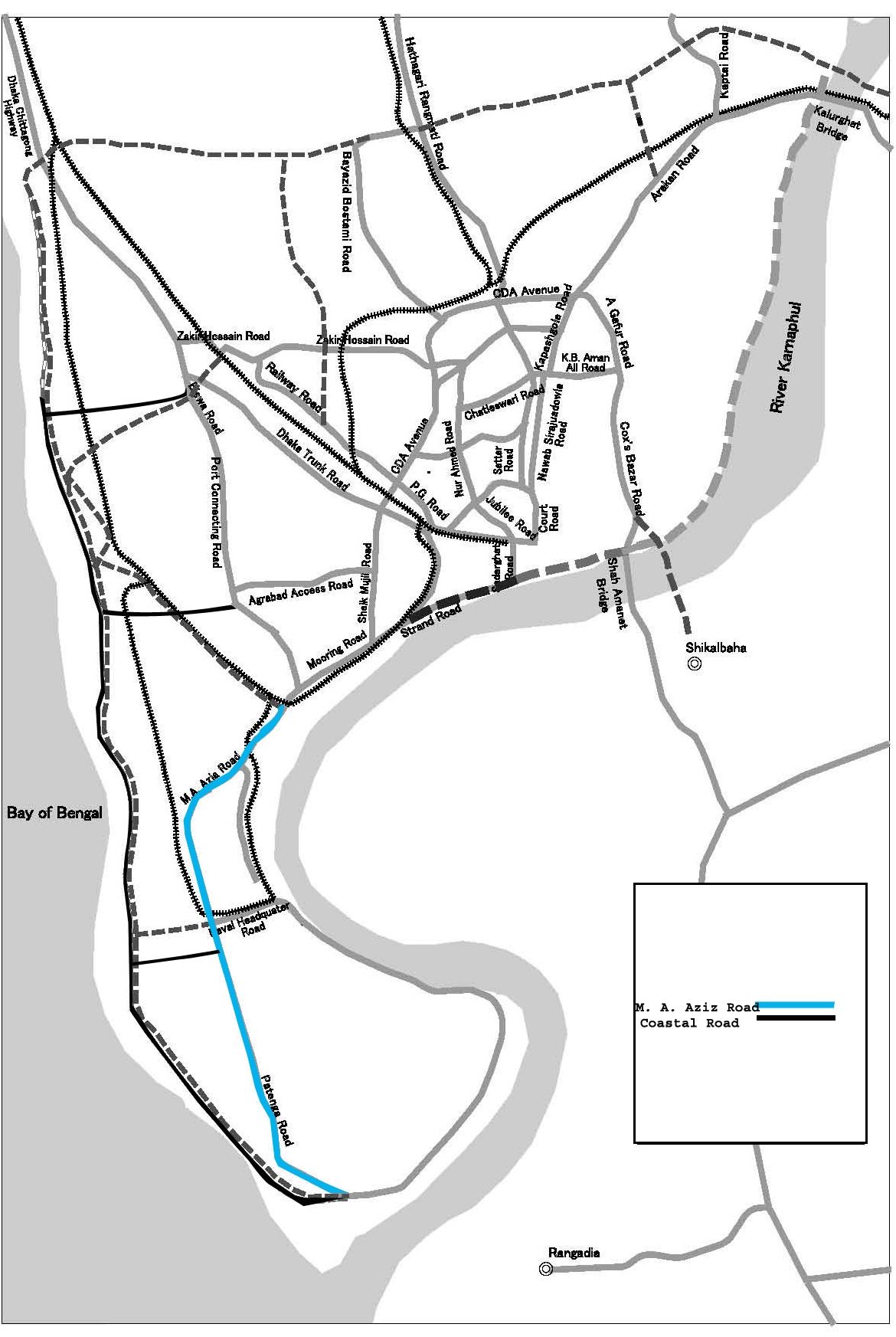
Existing Traffic Condition of the M. A. Aziz Road
The mainly adjacent road with the section of the ring road, from which traffic can be released by the coastal road and will be used as an alternative route, is the M. A. Aziz road. So the present traffic volume condition of the M. A. Aziz road is necessary to be studied.
Traffic Volume Analysis of M. A. Aziz Road
Traffic volume survey has been adopted as a method of measuring traffic volume in the study and the survey has been conducted in the year 2012. Survey has been conducted by dividing a day into two period- pick hour period and off-pick hour period. From 7.00-19.00 has been counted as peak hour because this time traffic volume is intense than the other period of the 24 hour. The rest period 19.00-7.00 has been counted as off-pick hour period.
From the traffic volume survey data of pick hour and off-pick hour, when the traffic volume is converted to the PCU unit (Appendix-1, 2),
The PCU/ hour in the pick-hour= 5021.833.
The PCU/hour in the off-pick hour= 2120.875
Comparison of the M. A. Aziz Road Traffic Volume with the Standard of HCM (1985)
In the Highway Capacity Manual (HCM) 1985, there are standards for uninterrupted flow which indicates specific volume of traffic in PCU unit for specific number of lanes. In the study, to understand the condition of the existing traffic flow of M. A. Aziz road, comparison has been made with the standard.
Table : Comparison of the M. A. Aziz Road Traffic Volume with the Standard of HCM (1985)
Source: Kadiyali, 2006., Calculation by the researcher.
| Highway Type | Capacity (In PCU) according to HCM manual (1985) | Comparison with the HCM Manual standard |
| Two-lane | Two way 2800 total, both directions | – |
| M. A. Aziz road (Pick hour) | 5021.833 | Exceeds the ideal capacity and cross the capacity approximately at double. |
| M. A. Aziz road (Off-pick hour) | 2120.875 | Within the capacity but nearer to the capacity. |
So, the result of the above table indicates the emergence of the management of the extra traffic load in M. A. Aziz road. Because in the peak hour, the existing traffic volume in this road creates severe traffic congestion which is one of the most unavoidable problem in the study area.
Not only in pick hour, the off-pick hour traffic volume also indicates the urgency of any solution because the existing condition will reach the road capacity soon and the day is not so far when traffic congestion will be unavoidable even at the off-pick hour period. This is the scenario of the traffic condition of 2012.
This is the only north-south axis road which serves the industrial hub of this zone. In the zone, major industrial establishments are situated, especially CEPZ and Chittagong Port, the rate of traffic volume of which are increasing in a rapid growth. So the traffic volume condition of this road will be deteriorating day by day.
As traffic congestion is a common phenomenon in this road in day time, excess load of traffic volume not only causes congestion in this road, but also deteriorates the level of service of the road by reducing the speed of vehicles in this road.
Travel Speed along M. A. Aziz Road
The travel speed data about the road is of the year 2008. Traffic moved the slowest in the evening (16:00 hour or 17:00 hour), indicating that traffic volume is the heaviest in the evening peak hours. Similar results were obtained by the JBIC study carried out in 2005. In particular, the average travel speed of vehicles traveling in the Patenga to City Gate direction was 24 km. In the Chittagong EPZ and other sections where congestion is severe, travel speeds were 20 km or slower (JICA, 2009).
Table: Travel Speed between Patenga to City Gate (km/hour)
| Start Point | Morning | Afternoon | Evening | End Point |
| Patenga | 33.3 | 30.2 | 24.1 | City Gate |
| End Point | Morning | Afternoon | Evening | Start Point |
| Patenga | 31.0 | 29.3 | 27.9 | City Gate |
Source: JICA, 2009.
Level of Service of M. A. Aziz Road According to the HCM Manual
There are standards about the level of service of roads in the HCM manual. So, according to this standard, the level of service of M. A. Aziz road can be assumed. Besides, the operating characteristics within the road for the specific level of services can be determined
Table : Level of Service of M. A. Aziz Road According to the HCM Manual
| Speed in KPH | Level of Service | Operating Characteristics | |
| 80 KPH or more | A | Relatively free flowing with service volume capacity ratio of .60 or less. Load factor at intersections about 0.0. Peak hour factor at .70 or less. | |
| Drops down to 40 KPH or more | B | Stable flow. Slight delay is common. Service volume capacity ratio is .70 or less. Load factor at intersections about 0.1 or less. Peak hour factor at .80 or less. | |
| Drops down to 40 KPH or more | C | Stable flow, with acceptable delays. Service volume capacity ratio is .80 or less. Load factor at intersections about 0.3 or less. Peak hour factor at .85 or less. | |
| Drops down to 25 KPH | D | Approaching unstable flow, with tolerable delay. Service volume capacity ratio is .90 or less. Load factor at intersections about 0.7 or less. Peak hour factor at .90 or less. | |
| 25 KPH to 15 KPH | E | Unstable flow, with congestion and intolerable delay. Service volumes are at capacity, or nearabouts. Load factor at intersections about 1.0 or less. Peak hour factor at .95 or less. | |
| Below 15 KPH | F | Forced flow, with jammed conditions. Demand volume capacity ration may well exceed 1.0. Intersections overloaded. | |
| Speeds in | |||
M. A. Aziz Road10 KPH-20 KPHE/ FUnstable flow or forced flow. Intolerable delay, congestion, jammed conditions are common. Service volume exceeds the capacity or at capacity at the ratio 1.00. Load factor at intersections about 1.0 or less. Peak hour factor at .95 or less or simply overloaded.20 KPH-30 KPHD/ EApproaching unstable flow or unstable flow, with tolerable/ intolerable delay. Service volume capacity ratio is .90 or less or volume at the capacity. Load factor at intersections about 0.7 or less/ 1.0 or less. Peak hour factor at .90 or less/ .95 or less.
Source: Kadiyali, 2006; JICA, 2009.
M. A. Aziz road is the only trunk road of the southern zone of Chittagong city. As the southern zone is an important zone for prominent industrial establishments and land uses, the level of service of this road should be well enough. The level of service of this road should be A, B or at least C. In the manual, Level of service C at least is recommended for good condition, where the level of service of this road is sometimes D, sometimes E or F according to the manual. So, unstable flow or forced flow is a common phenomenon for this road. Similarities can be found with the practical experiences with the operating characteristics according to the level of services of the road (Survey, 2012). This situation is very much unacceptable with the importance of the road. And this is because of the extreme pressure of the traffic volume on the road.
In future, the situation will be worsening. So, to re-establish the level of service A or B in the road, traffic volume load of this road should be lessened by diverting some traffic to another road, where the new coastal road is being expected to be an alternative route of the M. A. Aziz road.
As the project of the sectional ring road is for aiming the accommodation of the traffic volume of the year 2030, so to assess the necessity of the road, the traffic volume of M. A. Aziz road and the coastal road of 2030 is needed to be assumed.
Future Traffic Forecast of M. A. Aziz Road
The existing scenario of M. A. Aziz road provides the information that, the road is now overloaded and the level of service of the road is at the position of near the lowest. But if this situation is continued and if there would be no alternative route for this road, the probable scenario of the road should be illustrated to understand the condition.
To illustrate the probable future condition, traffic volume of this road has been illustrated for the year 2030, because traffic information about the new coastal road is available for the year 2030.
Relationship between GDP and Traffic Increase
Traffic volumes are generated as an integral part of a region’s socioeconomic activities, and therefore traffic volumes are believed to be closely linked to GDP, which is an indicator of overall socioeconomic activity.
There is a relationship between the traffic volume increase rate and the GDP increase rate, which has been explored from a Chittagong city road traffic study by RHD. This relationship is analyzed below on the basis of that study.
An analysis of the traffic increase on National Highway 1 was made on the basis of traffic counts carried out by the RHD in the past. From time to time, the RHD carries out traffic counts at key points along national highways. One of the counting stations is located near Fouzderhat, the ending point of the Coastal Road. While the station is outside the Chittagong City area, the data was used to conduct the following analysis.
Traffic counts from the above counting station are available for the years 1999, 2000, 2004 and 2007.
As seen, traffic on National Highway 1 shows a constant increase. However, the average increase in traffic as indicated by the regression line is only about 490 units annually, which is not a very steep growth.
On the assumption that traffic fluctuations on National Highway 1 reflect national economic trends, the Study plotted the relationship between the above count data and the nation’s GDP based on constant prices with 1995-1996 as the base year, as shown in Figure 5.3.
There is a solid correlation between the two other than in the year 2000, and it is believed that traffic volumes on National Highway 1 can be explained in terms of GDP trends.
Estimations of future traffic volumes often take into account the ratio of traffic increase to economic (e.g. GDP) growth. This ratio is called elasticity. In developing countries, the elasticity of traffic with respect to GDP is generally over 1.0, although there are differences based on vehicle type. The above traffic counts obtained from National Highway 1 give an elasticity of 0.8, which is slightly lower than the typical value for developing countries (RHD, 2008).
So, from figure of the relationship between GDP increase rate and traffic volume increase rate, the relational equation is,
Y= 3.3137x+ 6953.9
Where,
Y= Vehicle/ day
X= GDP at constant price.
So, for making the projection of traffic volume of 2030, data about GDP growth rate till 2030 is needed. But there cannot be found any official projections on long-term GDP growth. But data are available about the previous GDP record. So, an approximate assumption about the average GDP growth rate can be done.
| Year | 1999 | 2000 | 2001 | 2002 | 2003 | 2004 | 2005 | 2006 | 2007 | 2008 | 2009 | 2010 | 2011 |
| Bangladesh | 5.2 | 5.3 | 5.6 | 4.4 | 5.3 | 4.9 | 6.4 | 6.6 | 6.3 | 4.9 | 5.7 | 6 | 6.1 |
Table : GDP – growth rate of Bangladesh
Source: ADB, 2013
If we count the last five years GDP growth rate, the average growth rate stands at 5.8. But this rate is for the last five years, which can be used for only to assume the growth rate, but the projection of traffic volume for 2030 by using this GDP growth rate can give result far rich from the actual value.
There are some studies about the roads of Chittagong can be found which have conducted for various road projects and operation and maintenance project in the Chittagong city. In those studies, for the projections of traffic volume in the Chittagong city roads various traffic increase rate has been assumed.
Future Traffic Increase Rate Estimated by Other Studies
Traffic projections for Chittagong and its environs can be found in studies conducted by the ADB, RHD and others.
Table : Future Traffic Increases Estimated by Other Studies
| 4 Laning of Dhaka-Chittagong Highway | Port Access Road | Dhaka-Chittagong Access Controlled Highway | Road Network Maintenance and Improvement Project II | Average | |
| 2010-2020 | 6.0 | 6.3 | 6.13 | 5.41 | 5.96 |
| 2020-2030 | 5.0 | 6.3 | 5.58 | 3.18 | 5.02 |
Source: RHD, 2007; RHD 2008; ADB, 2008.
The average rates of traffic increase projected by the four main studies listed below are 5.96% for 2010 – 2020 and 5.02% for 2020 – 2030; these are also close to the result of the growth rate from GDP records in this study.
As traffic volume growth rate can be found for specific ten years from the above table and these have been calculated from the applied rates in various studies of Chittagong city, so these growth rates have been used in this study to make projection of the traffic volume of the year 2030.
Probable Traffic Volume at the Year 2020 and 2030 in PCU/ Hour
By using the traffic volume growth rate at 5.09% till 2020 and 5.02% till 2030, the following probable traffic volume can be found for the year 2020 and 2030.
Table : Probable Traffic Volume at the Year 2020 and 2030 in PCU/ Hour
| Roads | Probable Traffic Volume at the year 2020 in PCU/ hour | Probable Traffic Volume at the year 2030 in PCU/ hour |
| M. A. Aziz Road (From 7 am-7 pm) | 7979.908 | 13023.21 |
| M. A. Aziz Road (From 7 pm-7 am) | 3370.161 | 5500.103 |
Source: Calculated by the author.
If the total volume from the above result is run along the existing M. A. Aziz road, then the future traffic flow scenario of this road will be treacherous. The road will be fully incapable to function as a major trunk road of the southern zone of the city.
Where, already the traffic congestion is sometimes intolerable, so what will be the future scenario of the traffic volume of this road, if the same road has to accommodate the traffic volume of 2030.
In a study of JICA for Chittagong City Ring Road Project, .traffic flow of 2030 has been represented in a pictorial diagram. The Study carried out traffic assignment on how the two sets of OD trips (upper and lower estimates) obtained for the target year of 2030 will flow on the trunk road network in and around Chittagong City. Routes were selected on the basis of the minimum pass method, which is the method that is usually employed in such forecasting (JICA, 2009).
In the traffic assignment case where the OD trips projected for 2030 were assigned to a future road network that has no coastal road, traffic is heavy in Section A-A, indicating that the construction of four-lane roads is strongly required by 2030. If no such roads are constructed, traffic on the M.A. Aziz Road is predicted to exceed 70,000 vehicles per day, resulting in chronic congestion and creating an enormously adverse impact on the activities of the Chittagong and Karnaphuli EPZs and other industrial centers, as well as transport hubs such as Chittagong Port and the Chittagong International Airport.
The Port Connecting Road, which has sufficient right-of-way for four lanes but is currently functioning as a two-lane highway, will require two new lanes in the future in Section B-B. In the northern section, two to four lanes will be required. At present, the Dhaka-Chittagong Highway Project is under way, and if the highway is completed as a four-lane highway, capacity shortage in Section C-C will correspond to only about two lanes in 2030 (JICA, 2009).
Table : Required Number of Lanes by Section
| Section | Future Growth | Future Traffic |
(veh./day)Required No. of Lanes (a)Existing No. of Lane (b)(a) – (b)A – AHigh75,500624Low59,10064B – BHigh34,000422Low26,70042C – CHigh40,40062 (4)4 (2)*Low31,60042 (0)*
*: The number of lanes when Dhaka – Chittagong Highway will be completed.
Source: JICA, 2009.
If the Coastal road is constructed and can perform its full performances as believed by the project designers, then the probable traffic flow scenario in the existing roads and in the new road at 2030 will be more releasing.
Besides the M. A. Aziz road, there is another road, run parallel with the coastal road is named Port Access Toll Road. The traffic volume of this road is also can be diverted to the coastal road by adequate designing of the coastal road. So, the coastal road can also be act as an alternative route of the Port Connecting Road users if situation demands.
So, the traffic forecasting of the Port Access Toll Road is necessary to know the necessity of the coastal road from the Port Access Toll Road perspective.
Traffic Volume Forecast in the Port Access Toll Road
The Port Access Road is an access-controlled highway that directly links the Chittagong Port District with the Dhaka-Chittagong Highway (National Highway 1). It has one lane in each direction, and vehicles cannot enter/exit the road in the middle of its route. The Road links with the Dhaka-Chittagong Highway in the Fauzderhat District, at a point approximately 50 m to the north of the intersection between the Dhaka-Chittagong Highway and the Outer Ring Road (RHD, 2006).
Traffic forecasts for the Port Access Road are given in the February 1999 “Feasibility Study Report” and the June 2000 “Report on Highway Design Review and Technical Matters.” Traffic forecasts for the Port Access Road given in the above study were made by first establishing the assumptions that the growth rates of future traffic demand will be 8% from 2000 to 2008, about 6% from 2008 to 2014, and 5% from 2014 and thereafter and the road will be operated as a toll road. The actual commencement of service was in 2007 (RHD, 2006).
Table : Traffic demand Forecast on Port Access Road (veh./day)
| 2004 | 2008 | 2015 | 2024 | |
| Estimated Traffic Volume | 6,896 | 9,382 | 13,974 | 21,679 |
| Growth Rate (%) | – | 8.0 | 5.9 | 5.0 |
Source: RHD 2008.
Because the Port Access Road has only two lanes, its capacity is believed to be only about 16,000 vehicles per day under normal conditions. In the year 2015, traffic on the road is projected to increase to approximately 14,000 vehicles per day, at which point traffic on the road will be in near capacity. When traffic capacity will exceeds in port access road, traffic congestion would increase on the present port connecting road that passes through Chittagong City. Consequently air quality in the built-up town area would deteriorate and the air quality and noise level and the accident rate would increase (RHD, 2000).
So, the excess traffic will flow onto other roads in the city, further aggravating congestion in the Alonkar – Fauzderhat section, where traffic volume congestion already exists and where vehicles using the Port Connecting Road and the Dhaka-Chittagong Highway enter the City.
So traffic of this road should be systematically diverted to a new road, otherwise outflow onto other existing roads in the city is likely to trigger congestion on the two major routes mentioned above. And as the route of new Coastal Road is parallel to the Toll Road, if this road is systematically designed, can act as an alternative route of the toll road and can release the road from excessive traffic load as well as from the extra load in Alankar- Fauzdarhat section and Port Connecting Road.
Coastal Road Necessity from the Transport Perspective at a Glance
Elimination of Transport Bottlenecks
The M.A. Aziz Road is the only trunk road in Chittagong’s southern built-up district and the only road linking the district with the Chittagong and Karnaphuli EPZs and the Chittagong International Airport. This road fulfills vital roles as key arterial route. The roads are already operating exceeds the capacity. Traffic on the M.A. Aziz Road is forecast to increase to 13023.21 PCU/ hour in the pick hour in 2030. To process this volume adequately, the road will need to be widened to eight lanes. However, the roadside area has a high concentration of buildings, and widening would be extremely difficult to carry out. Without any alternative routes to the road, congestion will become chronic and stoppages may occur unexpectedly. Such conditions can greatly delay or prevent the transport of goods to and from the Chittagong EPZ and other important facilities, seriously affecting their operations. Besides, the traffic volume overview of Toll Road also indicates that traffic volume of this road will also rich the capacity in near future, which will create further problem in the inter city roads such as Port Connecting Road, Alankar to Fauzdarhat section simultaneously. So, the implementation of the coastal road has consecutive impact on the inter city roads and can release the inter city roads by consecutive outflow of the traffic from the central core of the city.
As indicated by the foregoing, the construction of the Coastal Road is greatly needed from the transportation perspective for the fruitful functioning of the existing roads.