The Global Positioning System (GPS) is a satellite navigation system that operates in space (GNSS). The positions of ground-based receivers can be calculated to high precision using GPS satellite signals, allowing the movement of points on the Earth’s surface to be tracked over time. The Global Navigation Satellite System, which is linked to a Japanese cell phone carrier, has the potential to improve monitoring of crustal deformation changes for earthquake early warning models.
Seismology and volcanology benefit greatly from monitoring crustal deformation. Various Global Navigation Satellite System (GNSS) networks have been built at the national and regional levels for such earth science fields and other purposes.
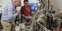
Japanese Earth Science researchers examined the potential of a dense Global Navigation Satellite System (GNSS) network, which is installed at cell phone base stations, to monitor crustal deformation as an early warning indicator of seismic activity in a paper published in Earth Planets and Space. The findings demonstrated that data from a cell phone network can rival the precision of data from a government-run GNSS network, while also providing more comprehensive geographic coverage.
The study paved the way for researchers in Japan and elsewhere to consider the synergy of public and private GNSS networks as a resource for seismic monitoring. The findings are critical for understanding earthquake phenomena and volcanic activity, which can help with disaster prevention and mitigation.
Yusaku Ohta
Crustal deformation is measured near plate boundaries, active faults, and volcanoes to assess the accumulation of strains that can cause major seismic events. GNSS networks have been built around the world in areas prone to volcanoes and earthquakes, such as Hawai’i, California, and Japan. Data from these networks can be analyzed in real-time to serve in tsunami forecasting and earthquake early warning systems.
Japan’s GNSS network (GEONET) is operated by the Geospatial Information Authority of Japan. While GEONET has been fundamental in earth science research, its layout of 20-25 kilometers on average between sites limits monitoring of crustal deformation for some areas. For example, magnitude 6-7 earthquakes on active faults in inland Japan have fault lengths of 20-40 kilometers; the GEONET site spacing is slightly insufficient to measure their deformation with suitable precision for use in predictive models.
However, Japanese cell phone carriers have constructed GNSS networks to improve locational information for purposes like automated driving. The new study examines the potential of a GNSS network built by the carrier SoftBank Corporation to play a role in monitoring crustal deformation. With 3300 sites in Japan, this private company oversees 2.5 times the number of sites as the government GEONET system.
“By utilizing these observation networks, we hope to understand crustal deformation phenomena at a higher resolution and to search for previously unknown phenomena,” said study author Yusaku Ohta, a geoscientist and assistant professor at Tohoku University’s Graduate School of Science.
The raw data provided by SoftBank GNSS from cell phone base stations was used in the study to assess its quality in monitoring crustal deformation. Two datasets were analyzed: one from a seismically quiet nine-day period in September 2020 in Miyagi Prefecture, Japan, and the other from a nine-day period that included a 7.3 magnitude earthquake off the coast of Fukushima Prefecture on February 13, 2021.
The study authors found that SoftBank’s dense GNSS network can monitor crustal deformation with reasonable precision. “We have shown that crustal deformation can be monitored with an unprecedentedly high spatial resolution by the original, very dense GNSS observation networks of cell phone carriers that are being deployed for the advancement of location-based services,” said earth scientist Mako Ohzono, associate professor at Hokkaido University.
In the future, they believe that combining the SoftBank sites with the government-run GEONET sites will result in better spatial resolution results for a more detailed fault model. Combining the networks in the Fukushima Prefecture would result in an average density of GNSS sites of one every 5.7 kilometers. “It suggests that these private sector GNSS observation networks can complement GNSS networks operated by public organizations,” Ohta said.
The study paved the way for researchers in Japan and elsewhere to consider the synergy of public and private GNSS networks as a resource for seismic monitoring. “The findings are critical for understanding earthquake phenomena and volcanic activity, which can help with disaster prevention and mitigation,” Ohzono said.