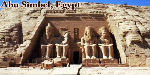
Abu Simbel (also Abu Simbal, Ebsambul or Isambul; Arabic: أبو سنبل, romanized: Abū Sinbal or Arabic: أبو سمبل, romanized: Abū Simbal) is a small village with beautiful views of the desert and lake, about 240 kilometers southwest of Aswan and near the border with Sudan. As of 2012, it has about 2600 inhabitants. It is best known as the site of two temples built by the Egyptian king Ramses II (reigned 1279–13 BCE), now located in Aswān muḥāfaẓah (governorate), southern Egypt.
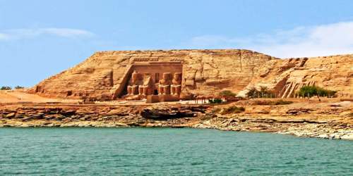
In ancient times the area was at the southern frontier of pharaonic Egypt, facing Nubia. The four colossal statues of Ramses in front of the main temple are spectacular examples of ancient Egyptian art. By means of a complex engineering feat in the 1960s, the temples were salvaged from the rising waters of the Nile River caused by erection of the Aswan High Dam.
The name Abu Simbel is European, a cacography of the Arabic Abu Sunbul, due in part to assimilation. Abu Sunbul is itself a derivative of the ancient place name Ipsambul. In the New Kingdom period, the region in which the temple was built may have been called Meha, but this is not certain. About 20 km southwest of Abu Simbel was the small village of Ibshek, which was somewhat north of the Second Cataract of the Nile, in present-day Sudan (Wadi Halfa Salient) flooded by Lake Nubia, near the border with Egypt.
The site of Abu Simbel is one of the most recognizable ancient sites in Egypt. For 3,000 years, it sat on the west bank of the Nile River, between the first and second cataracts of the Nile. However, in a remarkable feat of engineering, the temple complex was dismantled and rebuilt on a higher hill to make way for the Aswan High Dam in the 1960s.
Built-in 1244 B.C., Abu Simbel contains two temples, carved into a mountainside. The larger of the two temples contains four colossal statues of a seated pharaoh Ramesses II (1303-1213 B.C.) at its entrance, each about 69 feet (21 meters) tall. The entranceway to the temple was built in such a way that on two days of the year, October 22 and February 22, sunlight shines into the inner sanctuary and lights up three statues seated on a bench, including one of the pharaoh. Historians think these dates mark his coronation and birth. Thousands of tourists typically flock to the temples to watch the phenomenon and participate in the celebrations.
Discover, Location, and Climate –
Carved out of a sandstone cliff on the west bank of the Nile, south of Korosko (modern Kuruskū), the temples were unknown to the outside world until their rediscovery in 1813 by the Swiss researcher Johann Ludwig Burckhardt. They were first explored in 1817 by the early Egyptologist Giovanni Battista Belzoni.
Abu Simbel is in southern Egypt, not far from the border with Sudan. It is administratively part of the Aswan Governorate. The Sudanese border is only about 20 kilometers away to the southwest; the border departs from the 22nd parallel here and forms the Wadi Halfa Salient. However, the course of the border is disputed; Egypt claims the territory of the Wadi Halfa Salient up to the 22nd parallel in the south. The nearest city, Wadi Halfa, is located 65 kilometers southwest of Abu Simbel in Sudanese territory, on the east bank of Lake Nubia, the Sudanese name of Lake Nasser. The city was, like the Temple of Abu Simbel, relocated onto higher ground due to the flooding caused by the filling of the reservoir.
Abu Simbel is linked to the governorate capital of Aswan by a road that passes west of Lake Nasser, through the Libyan Desert. It is used predominantly by tour buses bringing visitors to the Abu Simbel temples, but it also has importance for the irrigation projects in the parts of the desert situated near the reservoir. Lake Nasser is navigable, so Abu Simbel is also reachable from the lakeside. A few cruise ships navigate the lake upstream of the Aswan Dam. The village is reachable by air via the Abu Simbel Airport.
Abu Simbel is located in one of the warmest and driest regions of Egypt. In the summer months, the high temperatures are easily 40 °C on average. Despite the great temperature differences between day and night, temperatures in summer seldom fall below 20 °C. Winters are mild with highs around 25 °C when temperatures can sometimes fall below 10 °C at night. Precipitation is so rare here that it is impossible to state a “rainy season” for Abu Simbel.
Moving the temple –
Abu Simbel survived through ancient times, only to be threatened by modern progress. Because the site would soon be flooded by the rising Nile, it was decided that the temples should be moved. “Following the decision to build a new High Dam at Aswan in the early 1960s, the temples were dismantled and relocated in 1968 on the desert plateau 64 meters (about 200 feet) above and 180 meters (600 feet) west of their original site,” writes Robert Morkot in an article in the “Oxford Encyclopedia of Ancient Egypt” (2001, Oxford University Press). The area where they were originally located is now flooded.
He noted that moving the temples was a massive job, one that involved cutting it into pieces between 3 to 20 tons in weight and re-assembling them precisely as they were. It took almost five years, involved about 3,000 workers and cost (in the 1960s) about $42 million. He notes in his book that it was a great success, one reporter present at its completion wrote that “everything looks just as it did before; it is enough to make one doubt that the temples were moved at all.”
History and Structure –
In the past, Abu Simbel was located on the west bank of the Nile between the first and second Cataracts of the Nile. Cataracts are rapids caused by boulders or rock sills; they were only passable with difficulty by Nile ship traffic, especially at baseflow. Today both cataracts near Aswan and Wadi Halfa are covered by Lake Nasser, which is named after Gamal Abdel Nasser, Egyptian president from 1954 to 1970. At the time of Ramses II, the southern border of the realm of the Pharaohs was located near the two cataracts. The construction of the Abu Simbel temple compound there was meant to demonstrate the power and eternal supremacy of Egypt with respect to the tributary Nubia.
The new dam flooded all of Lower Nubia, the inhabitants became homeless and were mostly resettled in the areas of Aswan and Kom Ombo. Only in Abu Simbel was a new village developed with a hotel and airport. Due to a lack of agricultural land, the entire population now depends on tourism. Since the turn of the millennium, various projects are underway with the goal of making the elevated desert regions fertile using water from the lake.
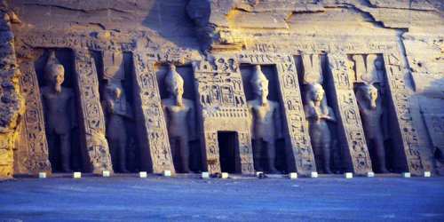
The 66-foot (20-meter) seated figures of Ramses are set against the recessed face of the cliff, two on either side of the entrance to the main temple. Carved around their feet are small figures representing Ramses’ children, his queen, Nefertari, and his mother, Muttuy (Mut-tuy, or Queen Ti). Graffiti inscribed on the southern pair by Greek mercenaries serving Egypt in the 6th century BCE have provided important evidence of the early history of the Greek alphabet. The temple itself, dedicated to the sun gods Amon-Re and Re-Horakhte, consists of three consecutive halls extending 185 feet (56 meters) into the cliff, decorated with more Osiride statues of the king and with painted scenes of his purported victory at the Battle of Kadesh. On two days of the year (about February 22 and October 22), the first rays of the morning sun penetrate the whole length of the temple and illuminate the shrine in its innermost sanctuary.
Just to the north of the main temple is a smaller one, dedicated to Nefertari for the worship of the goddess Hathor and adorned with 35-foot (10.5-metre) statues of the king and queen.
The Small Temple –
In addition, Abu Simbel has a second, smaller, temple that may have been built for queen Nefertari. Its front includes two statues of the queen and four of the pharaoh, each about 33 feet (10 meters) in height. Each is set between buttresses carved with hieroglyphs. The facade also contains smaller statues of the children, “oddly the statues of the princesses are taller than those of the princes,” a sign, perhaps, that this temple pays tribute to Nefertari and the women of Ramesses II’s household.
The interior of the temple is simpler than that of the great temple. It contains six pillars that show depictions of the goddess Hathor. On the “back wall of the room” are reliefs showing “Nefertari in the act of being crowned by the goddesses Hathor and Isis,” the queen wearing a head covering that shows “the solar disc with feathers between cow horns” the same head covering the goddesses are wearing.
Rediscovery –
In the mid-20th century, when the reservoir that was created by the construction of the nearby Aswan High Dam threatened to submerge Abu Simbel, UNESCO and the Egyptian government sponsored a project to save the site. An informational and fund-raising campaign was initiated by UNESCO in 1959. Between 1963 and 1968 a workforce and an international team of engineers and scientists, supported by funds from more than 50 countries, dug away the top of the cliff and completely disassembled both temples, reconstructing them on the high ground more than 200 feet (60 meters) above their previous site. In all, some 16,000 blocks were moved. In 1979 Abu Simbel, Philae, and other nearby monuments were collectively designated a UNESCO World Heritage Site.
Information Sources: