How much do climate change’s effects contribute to extreme weather events? It’s difficult to say the variables are numerous; each occurrence is unique, and there’s only so much we can do to figure out what didn’t happen.
However, new research by climate scientist Michael Wehner of the Lawrence Berkeley National Laboratory (Berkeley Lab) addresses the question for one specific element of one large storm and makes the data available to those who lived through it.
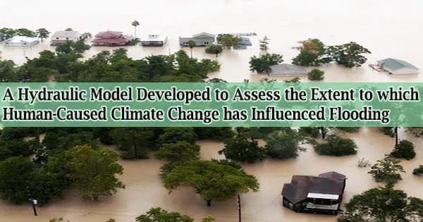
Wehner and Christopher Sampson of Fathom Bristol used a hydraulic model, a mathematical model that can analyze the flow of fluid through a particular system of natural or man-made channels, to assess the extent to which human-caused climate change may have influenced flooding in and around Houston during the massive 2017 storm, as well as the distribution of that flooding, in their paper “Attributable human-induced changes in the magnitude of flooding in the Houston, Texas region during Hurricane Harvey,” published May 19, 2021 in Climatic Change.
Wehner and Sampson used resources at the National Energy Research Scientific Computing Center (NERSC) to quantify the increase in Houston flood area and depth resulting from hydraulic model output, as well as to host a portal where other scientists and the general public can access the data for their own use.
Hurricane Harvey lingered over Houston from August 26 to August 31, 2017, flooding 154,000 structures and 600,000 automobiles, displacing 37,000 people and killing more than 70 people in the floodwaters.
It was the second-most expensive tropical storm in US history, costing between $85 billion and $125 billion when adjusted for inflation.
Wehner and Sampson used previously published estimates (Risser and Wehner 2017; Von Oldenborg et al 2017; Wang et al 2018) stating a range of a 7% to 38% increase in precipitation due to climate change during Hurricane Harvey to create a range of simulations showing the distribution of flooding around the Houston area, illustrating a variety of outcomes for different levels of attribution to climate change.
The amount of flooding you experienced depends a lot on where you are, whether you were victimized by the flood first of all, and then by whether or not climate change caused that flooding. That’s why this is an interesting data set. It’s so high-resolution that people can search for their own houses, or at least their own blocks, and see whether their house was flooded because of climate change at least according to these simulations.
Michael Wehner
The computational simplicity of hydraulic models, according to Wehner, allows for exceptionally fine resolution simulations in this situation, of about 30 meters (100 feet), or about the size of a single house and yard.
Residents can use the model to verify the flood condition of their homes or blocks in different predicted scenarios and observe how climate change may have directly affected them due to the granularity of the data.
“The amount of flooding you experienced depends a lot on where you are, whether you were victimized by the flood first of all, and then by whether or not climate change caused that flooding,” said Wehner.
“That’s why this is an interesting data set. It’s so high-resolution that people can search for their own houses, or at least their own blocks, and see whether their house was flooded because of climate change at least according to these simulations.”
That, he stressed, is part of the study’s motivation: not simply publishing the data, but making them widely accessible to other professional scientists, community scientists, and anybody else interested in looking at them.
Wehner, for example, has already begun sharing his data with a group of social scientists who want to use it to investigate Houston’s lopsided distribution of damages among ethnic groups.
On a larger scale, NERSC hosts a public-facing portal with Wehner and Sampson’s data in easily accessible format, as well as links to free software.
“It’s a scientific paper, but it’s really motivated as a public outreach,” said Wehner. “I’m trying to empower the public to go out and do their own finding, for people to say, I want to know if climate change impacted my neighborhood.”
This work may contribute to studies on the economic implications of climate change, in addition to community science and data sharing with other researchers.
“At the end of the day, our best estimate is that 14% to 15% of the cost of flooding during Hurricane Harvey is because of climate change, which doesn’t sound like a whole lot…but $13 billion does. And that’s going to grow as climate change continues,” said Wehner.