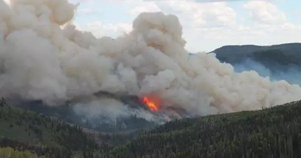
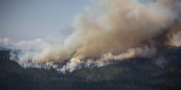
According to an experimental prediction method developed by scientists at the National Center for Atmospheric Research, this summer’s Western wildfire season is likely to be more severe than average but not as devastating as last year’s near-record (NCAR).
The new method, described in a peer-reviewed study, analyzes precipitation, temperatures, drought, and other climate conditions in the winter and spring to forecast the extent of wildfires across the western United States the following summer. The method was created by applying machine learning techniques to observations of every wildfire season since 1984, when current satellite measurements of fires first became available.
Although scientists had previously known that climate conditions during the spring and summer influence fire risk, the new study shows that the climate across large parts of the West plays an important role in setting the stage for the blazes even several months before peak fire season.
“Our findings show that the climate of the previous winter and spring can explain more than half of the year-to-year variability and overall trend in summer fire activity,” said NCAR scientist Ronnie Abolafia-Rosenzweig, the study’s lead author. “This allows us to forecast fire activity before the summer fire season begins.”
Our findings show that the climate of the previous winter and spring can explain more than half of the year-to-year variability and overall trend in summer fire activity. This allows us to forecast fire activity before the summer fire season begins.
Ronnie Abolafia-Rosenzweig
Applying their research method to the upcoming fire season, the scientists predicted that fires in the West will burn 1.9-5.3 million acres this summer, with 3.8 million acres being the most likely total. Although far short of the record 8.7 million acres burned in 2020, this would be the eighth largest burned area since 1984, part of a long-term trend of more widespread conflagrations.
The scientists stressed that their prediction is currently only for research purposes. However, they stated that their method, once further tested and improved, could help provide guidance to firefighting agencies in the future. It provides more specific information than current seasonal forecasts, which may predict a relatively mild or destructive wildfire season without predicting how many acres will burn.
“This information can be extremely useful to firefighting agencies as they allocate resources and prepare for the upcoming fire season,” Abolafia-Rosenzweig said.
Abolafia-Rosenzweig and his co-authors describe the prediction method in a new study in Environmental Research Letters. The work was supported by the NOAA MAPP program as well as the U.S. National Science Foundation, which is NCAR’s sponsor.
A persistent influence
With wildfires spreading across much of the West, the NCAR team wanted to see if early-year climate conditions could predict the size of the blazes during the summer, when fire season is at its peak.
Ensembles of generalized additive statistical models, which are widely used machine learning tools that help reveal complex relationships – in this case, the correspondence between climate conditions from November to May and the extent of burned areas from June to September – were used by the scientists. They looked at every year since 1984, focusing on Western regions that rely on snowpack for water.
The research team found that the dryness of air (vapor pressure deficit) in the lowest part of the atmosphere during winter and spring has a particularly pronounced effect on summertime fires. That dryness influences the amount of snow that falls and, in turn, is affected by snow on the ground that eventually releases moisture to the overlying air. The extent of April snowpack is especially significant because it moistens both the ground and air as it melts during the warmer months.
“We discovered that the April snowpack has a persistent influence on the land and atmosphere throughout the summer,” Abolafia-Rosenzweig said. “If there is a large snowpack in April, it will take longer to melt, and moisture will be transferred from the land to the atmosphere more persistently from late spring to summer. However, with less snowpack, you’ll have a drier land surface and a drier atmosphere in summer, which results in conditions that are more conducive to fire spread.”
The researchers also looked at a variety of other climate variables, such as precipitation, temperature, soil moisture, evapotranspiration, and drought indexes, to see how each variable affects the size of summer fires at different times of year.
They concluded that winter and spring climate conditions can be used to predict up to 53% of the year-to-year variability in summer burned areas. When summertime climate conditions such as precipitation and the dryness of the air are also factored in, the explained variability increases to 69%.
The study also looked at the overall impact of climate change on fire activity in the West. As wildfires have gradually grown in size since 1984, the research team’s modeling showed that climate variables such as rising temperatures and persistent droughts can explain 83% of that increase.
This year’s experimental prediction — which encompasses the entire West, not just snow-reliant regions — indicates that fires will burn 38% more of Western lands this summer than the average since 1984. The prediction does not include early-season fires before June, such as the widespread blazes that have devastated New Mexico this spring, nor does it estimate how various Western regions will fare. In the future, however, the scientists may add such details.
“Our plan is to include local climate variables like winds so we can know the specific fire conditions on a state or even county level,” said NCAR scientist Cenlin He, one of the study’s co-authors. “This will make it more valuable to stakeholders and fire managers, allowing them to forecast fire activity in specific areas of the West.”