Saint-Pierre and Miquelon (/ˈmɪkəlɒn/), officially Territorial Collectivity of Saint-Pierre and Miquelon, French Collectivité Territoriale de Saint-Pierre et Miquelon (sɛ̃ pjɛʁ e miklɔ̃), archipelago about 15 miles (25 km) off the southern coast of the island of Newfoundland, Canada, a collectivité of France since 1985. It is a last remaining piece of New France’s once-vast land. Its inhabitants are French citizens, and the collectivity elects its own representative to the National Assembly and runs candidates for president and senator.
The area of the main islands is 93 square miles (242 square km), 83 square miles (215 square km) of which are in the Miquelons (Miquelon and Langlade, sometimes known as Great and Little Miquelon, connected by the slim, sandy Isthmus of Langlade). But the island of Saint-Pierre, only 10 square miles (26 square km) in area, has almost 90 percent of the total population and is the administrative and commercial centre.
The Saint Pierre and Miquelon archipelago is located about 25 kilometers off the coast of Canada, close to France. The accent is reminiscent of Quebec, the dwellings are as colorful as those in a Scandinavian nation, and the Basque festivals blend well with Breton pancakes.
It is a location of pure nature where one never gets tired of observing the vistas between land and sea while looking for seals, humpback whales, and migratory birds. It is not just a singular culture to be discovered at the discretion of its small unusual museums. Native Americans, like the Beothuk, visited St. Pierre and Miquelon, according to archaeological evidence, although it is not believed that they made the islands their permanent home.
Small groups of colonists from Great Britain and Britain’s American colonies started to settle on the islands when the British changed the name of the island of Saint Pierre to Saint Peter. The island of Miquelon has a rocky cape, about 1 mile (1.6 km) wide, that extends to the northeast for about 4 miles (6 km). The Plain of Miquelon, to the south of the cape, is an area of peat bogs and marshes with many small lakes; the southern part of the island is characterized by rugged, barren hills (the Mornes) that rise to Morne de la Grande Montagne (787 feet (240 metres)), the highest point on the archipelago.
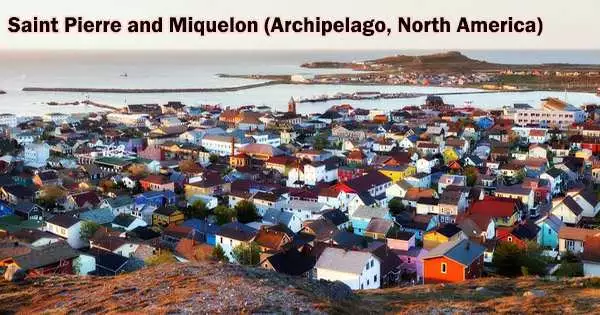
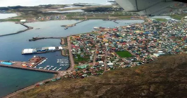
On the eight islands of the archipelago, only two of them are inhabited, mainly that of Saint-Pierre, a pocket island of 26 square kilometers and 5 500 inhabitants! In Saint-Pierre, where wooden cottages are painted in the brightest hues like lemon yellow, brick red, and turquoise blue, life is concentrated. A lovely green dapper adorns the Heritage Museum. Its varied collections make it a great starting point for learning about the archipelago’s history, notably during American Prohibition in the 1930s.
After France entered the American Revolutionary War on the side of the United States and declared war on Britain, a British force invaded Saint Pierre and Miquelon and briefly occupied them, destroying all colonial settlements on the islands and deporting 2,000 colonists back to France. In 1793, during the French Revolutionary Wars, another British force landed in Saint Pierre and, in the following year, again deporting the French colonial population, and tried to establish a community of Anglophone settlers.
The island of Langlade is an ancient peneplain (nearly flat surface produced by erosion) drained by numerous short rivers, including the Belle, the largest, which flows to the northwest. The coast of Langlade is lined with cliffs, except to the north, where it is joined to Miquelon by the Isthmus of Langlade.
Saint-Pierre, located to the southeast of Langlade across La Baie, a channel about 3 miles (5 km) wide, comprises a region of rugged hills to the northwest and a rocky lowland to the southeast; both areas of the island have peat bogs and small lakes and ponds. Saint-Pierre’s coast is varied, with cliffs to the north and irregular capes and points to the south. The archipelago includes a number of rocky islets; the only one that is inhabited is Marins (123 acres (50 hectares)) off the eastern coast of Saint-Pierre.
Smuggling has always been a significant economic activity on the islands, but in the 1920s it really took off after the United States passed Prohibition in January of that year. In 1931 the archipelago was reported by the New York Times to have imported 1,815,271 U.S. gallons (1,511,529 imperial gallons; 6,871,550 liters) of whisky from Canada in 12 months, most of it to be smuggled into the United States. The end of Prohibition in 1933 plunged the islands once more into economic depression.
The island of Saint-Pierre also lends itself to pretty walks between ocean and ponds. And a few hundred meters from the shore, the nature reserve of the Grand Colombier is one of the favorite spots of ornithologists. This sanctuary which concentrates a good part of the migratory birds is the only site where the puffins monks nest. Torda and offshore penguins, humpback whales, whales and dolphins are also seen here.
Despite a mild, humid climate, the archipelago is stark in appearance, the forest cover of the hills, except in parts of Langlade, having been removed for fuel long ago. Mean monthly temperatures range from 14 °F (−10 °C) in the winter months to 68 °F (20 °C) in the summer, and the average annual precipitation is about 59 inches (1,500 mm). Seabirds are the most common fauna.
France is responsible for the defence of the islands. The French Navy has maintained a patrol boat, the ex-trawler Fulmar, in the region since 1997. Law enforcement in Saint Pierre and Miquelon is the responsibility of a branch of the French Gendarmerie Nationale; there are two police stations in the archipelago. A third, formerly inhabited island, Isle-aux-Marins, known as Île-aux-Chiens until 1931 and located a short distance from the port of Saint-Pierre, has been uninhabited since 1963. The other main islands are Grand Colombier, Île aux Vainqueurs, and Île aux Pigeons.
A trip to St. Pierre and Miquelon can not omit the island of Miquelon, the largest (216 km2), actually formed of three peninsulas:
- The cap,
- Great Miquelon,
- Langlade sometimes called small Miquelon.
The average temperature is 5.3 °C (41.5 °F), with a temperature range of 19 °C (34 °F) between the warmest (15.7 °C (60.3 °F) in August) and coldest months (−3.6 °C (25.5 °F) in February). Precipitation is abundant (1,312 mm or 51.7 in per year) and regular (146 days per year), falling as snow and rain.
The importance attached to this last foothold in North America has led France to subsidize the islands, since the meagre local resources cannot support the population; about 70 percent of the islands’ supplies are imported from Canada or from France via Nova Scotia. Cod fishing is still virtually the only occupation; frozen and dried fish, as well as fish flour, are the main exports.
A true concentrate of pure nature that one explores by boat or on foot. In the beautiful lagoon of Grand Barachois with blue waters, one embarks on zodiacs to observe gray seals and harbor seals, which one can also cross at Cap Percé. At the extreme north-west of the island, Cape Miquelon is spectacular with its setting of cliffs overlooking the ocean, where birds of prey nest. And the Cormorandière valley in Miquelon lends itself perfectly to eco-walks between peat bogs and the boreal forest, the only one in France.
Because of its location at the confluence of the cold waters of the Labrador Current and the warm waters of the Gulf Stream, the archipelago is also crossed a hundred days a year by fog banks, mainly in June and July. Two other climatic elements are remarkable: the extremely variable winds and haze during the spring to early summer.
More than 300 varieties of marine and terrestrial migratory birds are recorded in the archipelago of Saint-Pierre-et-Miquelon, including about 100 breeding species. Eider, large migratory ducks whose down is sought after, goldeneyes or white-winged pyramids are on display here.
In May 1985 the islands were given a new status with a new name, collectivité, because the former departmental arrangement conflicted with the tariff structure of the European Community (now European Union), to which France belongs. Every summer there is a Basque Festival, which has demonstrations of harrijasotzaile (stone heaving), aizkolari (lumberjack skills), and Basque pelota. The local cuisine is mostly based on seafood such as lobster, snow crab, mussels, and especially cod.