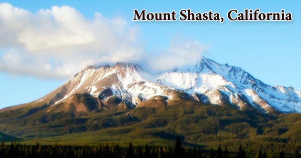
Mount Shasta (Karuk: Úytaahkoo or “White Mountain”), the highest point in the Cascade Range (14,162 feet (4,317 meters)), is located in the Shasta-Trinity National Forest in northern California, United States. It is the United States’ second highest volcano and a major peak of the Cascade Range and Pacific Ring of Fire. It is a potentially active volcano in Siskiyou County, California, at the southern end of the Cascade Range. Mount Shasta, which is not linked to any neighboring peak, rises majestically nearly 10,000 feet (3000 meters) above the surrounding terrain. It is the most voluminous stratovolcano in the Cascade Volcanic Arc, with an approximate volume of 350 km3 (85 cubic miles).
In a condition of superlatives, Mount Shasta is the superlative mountain. The stratovolcano is one of the grandest summits in the American West, cloaked in glaciers and featuring epic shows of lenticular cloud formations. The mountain can be seen from the Central Valley floor 140 miles (230 kilometers) to the south on a clear winter day. Poets, writers, and presidents have all been drawn to the mountain. This majestic mountain reaches a height of 14,179 feet and has a base that stretches more than 17 miles. Poets, writers, and ufo-watchers have been drawn to the spectacular and beautiful peak, which is regarded as a spiritual power center by many.
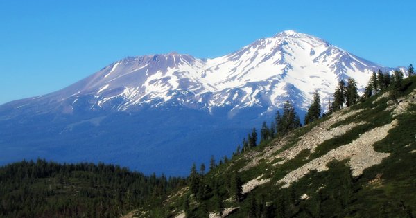
The mountain is made up of four overlapping dormant volcanic cones that have formed a complex shape, including the main summit and the prominent satellite cone Shastina, which has a visibly conical shape and stands at 12,330 feet (3,760 meters). Mount Shasta’s largest subordinate mountain, Shastina, is the range’s third highest summit. Shasta is also one of the Cascade’s youngest major volcanoes. The pointed, conical cap of the mountain reflects this. Mounts Rainier, Adams, and Hood, for example, are older and have broader, more rounded summits. It last erupted in 1786, but the region is still tectonically active, with earthquakes occurring frequently.
Shasta is notable geologically for a massive landslide that wiped out the volcano’s entire northern side between 300,000 and 360,000 years ago. Except for the south slope, where Sargents Ridge runs parallel to the U-shaped Avalanche Gulch, its terrain is relatively free of deep glacial erosion. While there is no longer a glacier in this valley, it is the volcano’s largest glacial valley. It is one of the world’s biggest avalanches, with an approximate volume of 6.5 cubic kilometers. The slide flowed northwestward into Shasta Valley, where the Shasta River now cuts through the debris flow deposit, which is 28 miles (45 kilometers) deep.
Despite its formidable nature, Mount Shasta provides leisure opportunities for people of all abilities. On Shasta, one can find intense multi-day treks up major glaciers or peaceful hikes through lush meadows. On Mount Shasta, there are seven called glaciers, with the four largest (Whitney, Bolam, Hotlum, and Wintun) radiating down from the main summit cone to below 10,000 feet (3,000 meters), mainly on the north and east sides. The Watkins, Konwakiton, and Mud Creek glaciers are among the smaller named glaciers that occupy cirques near and above 11,000 feet (3,400 meters) on the south and southeast sides.
On the south side of Mount Shasta, Sargents Ridge exposes the mountain’s oldest remaining sections. At Mount Shasta’s southern foot, andesitic lavas from the Sargents Ridge vent cover the Everitt Hill shield. The area’s oldest recorded human settlement dates from about 7,000 years ago. The Shasta, Okwanuchu, Modoc, Achomawi, Atsugewi, Karuk, Klamath, Wintu, and Yana tribes were among the Native American tribes living within sight of Mount Shasta at the time of Euro-American contact in the 1820s.
Misery Hill, the second oldest cone to develop, is visible south of Mount Shasta’s current summit. It was formed 15,000 to 20,000 years ago by andesite flows, and a hornblende dacite dome later intruded. Lapérouse may have seen a historic eruption of Mount Shasta in 1786, although this is debatable. The 1786 eruption is debunked, according to the Smithsonian Institution’s Global Volcanism Program, and the last recorded eruption of Mount Shasta occurred around 1250 AD, as confirmed by uncorrected radiocarbon dating.
Mount Shasta is a formidable opponent. There is no “simple” path to the top, and all routes are extremely strenuous. All routes require more than 7,000 vertical feet of climbing and almost often necessitate the use of an ice axe and crampons to safely cross sections of snow and ice. The Hotlum Cone, which evolved around 8,000 years ago, is Mt Shasta’s most recent and highest cone. The Hotlum glacier on its northern face is named after it, and its longest lava flow, the 500-foot-thick Military Pass flow, stretches 5.5 miles (8.9 kilometers) down its northwest face.
The Pacific Highway preceded the Siskiyou Trail to the base of Mount Shasta in the early twentieth century, providing yet further access to the peak. Thousands of people visit Mount Shasta each year thanks to today’s version of the Siskiyou Trail, Interstate 5. A dacite dome has intruded the Hotlum Cone since its formation and now forms the summit. The rock at the summit crater’s 600-foot-wide (180-meter-wide) summit crater has been significantly altered by sulfurous hot springs and fumaroles. The Hotlum Cone has erupted at least eight or nine times in the last 8,000 years.
Mount Shasta has erupted on average every 800 years over the last 10,000 years, but every 600 years over the last 4,500 years. Mount Shasta’s last major eruption may have occurred about two centuries ago. The most green forest within the boundary can be found on the mountain’s northeast and southeast slopes. The rest of the region is covered by glaciers, tundra, and vast scree fields, with small meadows scattered along Mount Shasta’s lower flanks. Several lava flows can also be found in the wilderness area, the majority of which are on the mountain’s north side. Volcanic ash, pyroclastic flows, and dacite and andesite lava are all potential eruptions from Mount Shasta. Its traces can be found under neighboring small towns. Mount Shasta is monitored by the US Geological Survey and is classified as a very high-threat volcano.
Information Sources: