Mahasthangarh (Bengali: মহাস্থানগড় Môhasthangôṛ) is the oldest archaeological site and the oldest known city in Bangladesh. It dates back to 700 BCE and was the ancient capital of the Pundra Kingdom. It is one of the earliest urban archaeological sites so far discovered in Bangladesh. The village Mahasthan in Shibganj thana of Bogra District contains the remains of an ancient city which was called Pundranagara or Paundravardhanapura in the territory of Pundravardhana. A limestone slab bearing six lines in Prakrit in Brahmi script recording a land grant, discovered in 1931, dates Mahasthangarh to at least the 3rd century BC. The fortified area was in use until the 8th century AD.
The word ‘Mahasthan’ means a place that has excellent sanctity and ‘Garh’ means fort. The extensive ruins of Mahasthangarh present a glorious past of about two thousand and five hundred years of Pundranagar, the capital city of ancient Pundra Vardhan Bhukti.
Mahasthangarh, spreading along the western bank of Korotoa river, is situated about 13 km north of Bogra town. This earliest and largest city of entire Bengal is fortified successively by mud and brick wall. It measures 1,525-meter long North-South, 1,370 miters broad East-West, and 5 meters high above the surrounding level. The river in the east and a deep moat on the west, south, and north served as additional defense apart from the citadel wall.
Etymology –
Mahasthan was first mentioned in a Sanskrit text of the 13th century entitled Vallalcharita. It is also mentioned in an anonymous text Karatoya mahatmya, circumstantially placed in 12th 13th century. The same text also mentions two more names to mean the same place Pundrakshetra, land of the Pundras, and Pundranagara, city of the Pundras. In 1685, an administrative decree mentioned the place as Mastangarh, a mixture of Sanskrit and Persian meaning fortified place of an auspicious personage. The present name of Mahasthangarh is of later origin.
Later discoveries have led researchers to the conclusion that the name of the area was initially Paundravardhanapura or Pundranagara, referring to the Pundra Kingdom in Indian epic literature, which was said to rule over an area stretching from West Bengal, to Bangladesh and into the area of India now known as Bihar.
Geography –
Mahasthangarh (Pundranagar), the ancient capital of Pundravardhana is located 11 km (6.8 mi) north of Bogra on the Bogra-Rangpur highway, with a feeder road (running along the eastern side of the ramparts of the citadel for 1.5 km) leading to Jahajghata and site museum. It is believed that the location for the city in the area was decided upon because it is one of the highest areas in Bangladesh. The land in the region is almost 36 meters (118 ft) above sea level, whereas Dhaka, the capital of Bangladesh, is around 6 meters (20 ft) above sea level. Another reason for choosing this place was the position and size of the Karatoya, which as recently as in the 13th century was three times wider than Ganges.
Mahasthangarh stands on the red soil of the Barind Tract which is slightly elevated within the largely alluvium area. The elevation of 15 to 25 meters above the surrounding areas makes it a relatively flood-free physiographic unit.
History and Discover–
The archeological site of Mahasthangarh is located on one of the highest pieces of land in Bangladesh, along the Bogra-Rangpur highway, allowing easy access for visitors. The site was discovered in the early 1800s and a number of world-renowned archeologists were instrumental in uncovering its cultural and historical significance. From the archaeological evidence, it is proven that Mahasthangarh was provincial capital of the Mauryans, the Guptas, the Palas, and the Feudal Hindu kings of later period. Beyond the citadel, other ancient ruins found within a radius of 7/8 km in a semi-circle in the north, south, and west which testify the existence of extensive suburbs.
It is worth quoting that Yuen Chwang, the famous Chinese pilgrim visited the Pundra Vardhana in between 639-645 A.D. Sir Alexandar Cunningham rightly identified the current Mahasthangarh as Pundranagar at 1879 following the description left by Yuen Chwang.
The whole area is rich in Hindu, Buddhist, and Muslim sites. The Buddhists were here until at least the 11th century. Their most glorious period was the 8th to the 11th centuries when the Buddhist Pala emperors of North-Bengal ruled. It is from this period that most of the visible remains belong. The citadel was probably first constructed under the Mauryan empire in the 3rd century B.C.
Mahasthangarh fell into disuse around the time of Mughal invasions. Most of the visible brickwork dates from the 8th century, apart from that added during restoration. Outside the citadel, there is a remaining of a 6th century Govinda Bhita Hindu Temple, which looks like a broken-down step pyramid.
Visitors to the site will note that the Karatoya River flows to the east of the rectangular citadel. Although this river is currently not much more than a stream, it was once a mighty river, considered being sacred. It has been suggested that the proximity of the Karatoya River may have been one of the deciding factors when the founders of the settlement chose the site.
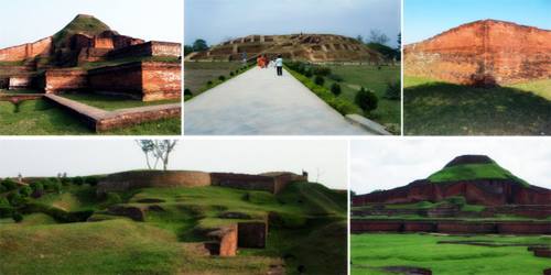
Within the fortifications of the city are a number of interesting features, including a well said to possess life and impart power known as Jiat Kunda; a palace called Parasuramer Basgriha dedicated to a king by the name of Parasuram; a place of stone said to be bestowed by God known as Khodar Pathar Bhita; and a bastion named Munir Ghon. There are gateways on all four sides and a flight of steps in the north-eastern corner.
Outside the fortifications are up to a hundred mounds spread over a radius of around nine kilometers, many of which still need to be excavated. On the banks of the Karatoya River is a temple dedicated to Govinda, as well as a museum displaying some of the fascinating artifacts discovered in and around the settlement. These include a limestone slab inscribed with words in Brahmi script dating back to the 3rd century BC; silver punch market coins from between the 4th century BC and the 1st to 2nd century AD; coins of the British East India Company which was founded in 1600; shards of ceramics; a 5th century stone sculpture of Buddha; and terracotta plaques.
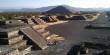
Structures of Some Excavated Sites –
Mahasthangarh is a fascinating place to visit from a historical and cultural perspective, and from its elevated position it offers spectacular views of the surrounding areas.
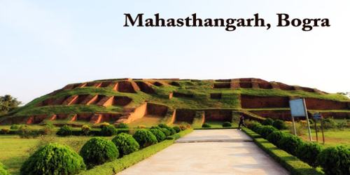
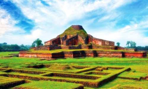
The citadel, the fortified heart of the ancient city, is rectangular in plan, measuring roughly 1.523 kilometers (0.946 mi) long from north to south, and 1.371 kilometers (0.852 mi) from east to west, with high and wide ramparts in all its wings. Area of the citadel is approximately 185 ha. The Karatoya, once a mighty river but now a small stream, flows on its east. Citadel has several gateways – Kata Duar in the north, Dorab Shah Toran in the east, Burir Fatak in the south and Tamra Dawaza in the west
There are remnants of many interesting buildings inside the citadel. Some of these structures are:
- Bairagir Bhita – Constructed/ reconstructed in four periods: 4th–5th century AD, 6th–7th century, 9th–10th century, and 11th century. Excavations have revealed impoverished base ruins resembling temples. Two sculptured sandstone pillars have been recovered.
- Jiat Kunda – well which, according to legends, possessed life-giving power. According to legends, dead soldiers were revived with its water during the fights.
- Khodar Pathar Bhita – Buddhist shrine.
- Munir Ghon – impressive bastion.
- Parasuramer Basgriha – palace of king Parasuram, in use from 800 AD to 1800 AD.
Hundreds of mounds scattered for kilometers to the north, west, and south from the citadel testify that Mahasthangarh was a true metropolis also by today’s scale. Each of these mounds hides some important ancient structure or group of structures. Most of these mounds are unexplored up to this day, but some of the most interesting explored sites are:
- Govinda Bhita – Temple of Govinda is located to the north-east from the city walls, at Karatoya river. This is ancient building, possibly from the 3rd century AD, although here have been found artefacts from the 3rd century BC.
- Mazar – Holy tomb of Shah Sultan Balkhi Mahisawar with later built mosque next to it. This structure is located at the south-eastern corner of citadel, in the site of an ancient Hindu temple.
- Gokul Medh, also known as Behular Basar Ghar or Lakshindarer Medh, is located some 3 km south from the citadel. This Buddhist monastery belongs to most impressive archaeological sites in this area. This enormous structure was excavated in 1934-1936, when 172 rectangular blind cells were exposed. Gokul Medh was built in the 6th-7th century AD. On the top of this approximately 13 m tall structure was standing stupa which is lost now.
In a 2010 report titled Saving Our Vanishing Heritage, Global Heritage Fund identified Mahasthangarh as one of 12 worldwide sites most “On the Verge” of irreparable loss and damage, citing insufficient management (poor water drainage in particular) and looting as primary causes.
Information Sources: