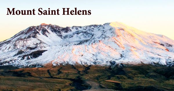
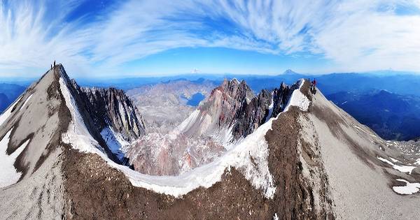
Mount Saint Helens (known as Lawetlat’la to the Indigenous Cowlitz people, and Loowit or Louwala-Clough to the Klickitat), is a volcanic mountain in the Cascade Range in southwestern Washington, United States. It is located 50 miles (80 kilometers) northeast of Portland, Oregon, and 96 miles (154 kilometers) south of Seattle, Washington. On May 18, 1980, it erupted in one of the most powerful volcanic explosions ever seen in North America. During the 1980 eruption, a large debris avalanche removed the upper 400 meters (1,300 feet) of the summit, leaving a 2 × 3.5 km (1.2 × 2.2 mi) horseshoe-shaped crater that is now partly filled by a lava dome and a glacier.
Mount St. Helens was named after Lord St Helens, a British diplomat who was a friend of explorer George Vancouver, who undertook a survey of the region in the late 1800s. The volcano was formed over four eruptive stages starting about 275,000 years ago, and during the Holocene, it was the most active volcano in the Cascade Range. Tephra, lava domes, and pyroclastic flows erupted prior to around 12,800 years ago, creating the older St. Helens edifice, although a few lava flows spread beyond the volcano’s foundation. The volcano is part of the Cascade Volcanic Arc, a segment of the Pacific Ring of Fire that includes over 160 active volcanoes, and is located in the Cascade Range. It is well-known for its pyroclastic flows and ash explosions.
Mount St. Helens and the Cascade Range are part of the Ring of Fire, a region of extreme volcanic and seismic activity that encircles the Pacific Ocean and stretches from the west coast of South America to Alaska and the Aleutian Islands. Mount St. Helens is best known for its massive eruption on May 18, 1980, which was the deadliest and most economically damaging volcanic occurrence in American history. Fifty-seven people were killed, with 250 houses, 47 bridges, 15 miles (24 kilometers) of railway, and 185 miles (298 kilometers) of highway damaged.
Mount St. Helens started rising before the end of the Ice Age, according to the USGS, with the earliest ash deposits dating back at least 40,000 years. The visible part of the volcano’s cone, on the other hand, is much younger. It is believed to have evolved during the last 2,200 years, according to geologists. On the morning of May 18, 1980, a magnitude 5.1 earthquake on the Richter scale caused a massive landslide on the mountain’s north face. A lateral air blast brought a high-velocity cloud of superheated ash and stone outward 15 miles (25 km) from the volcano’s summit, reaching temperatures of 660°F (350°C) and speeds of at least 300 miles (500 km) per hour.
St. Helens’ magma erupted into a massive pyroclastic flow that flattened trees and buildings across 230 square miles (600 km2). Sulfur dioxide in the quantity of 1.5 million metric tons was released into the atmosphere. The eruption received a 5 on the Volcanic Explosivity Index scale and was classified as a Plinian eruption. The May 18 event claimed the lives of 57 people and thousands of animals, and the lateral air blast blew down trees over a 200-square-mile (500-square-kilometer) field. Mount St. Helens’ volcanic cone had been entirely blown away by the end of the disaster, leaving a horseshoe-shaped crater with a rim reaching an elevation of 8,363 feet in its place (2,549 metres).
The volcano’s top 1,300 feet were ripped off by the lateral explosion, leaving a new crater behind. Any tree within a six-mile radius was killed, and others were scorched. Four billion board feet of timber is estimated to have been lost. Pyroclastic flows, which are fast-moving bursts of deadly superheated volcanic gas and pumice, were also caused by the lateral explosion. There were more eruptions until 1986, and a lava dome formed intermittently in the crater. Between 1989 and 1991, as well as 1995 and 1998, there was more seismic activity (including a few minor explosions).
Early settlers experienced historical eruptions in the 19th century that emerged from the Goat Rocks field on the north flank. Unpublished data on the timing of Mount St. Helens eruptive activity has been analyzed, and some of the published eruption dates have been improved. On March 8, 2005, Mount St. Helens emitted a 36,000-foot (11,000-meter) plume of steam and ash that could be seen from Seattle. This minor eruption was a release of pressure related to the ongoing dome construction. A magnitude 2.5 earthquake followed the announcement.
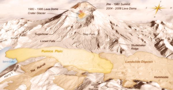
The National Volcanic Monument was established in 1982 on 110,000 acres of land surrounding Mount St. Helens and within the Gifford Pinchot National Forest. The National Monument was established for the purposes of science, recreation, and education. The monument offers a once-in-a-lifetime opportunity for scientists to study the dynamics of an active composite volcano and to learn more about how ecosystems respond to cataclysmic events. There are various leisure and educational programs available at the monument.
From Johnston Ridge Observatory on the monument’s west side, less than 5 miles (8 kilometers) from the volcano, visitors can see the crater, lava dome, pumice plain, and landslide impacts. The National Volcanic Monument is slowly coming back to life, decades after the 1980 destruction. Spirit Lake has resurrected, but it is now shallower than before. Trees and other forest vegetation are increasing, and large and small mammals, as well as some bird species, insects, and aquatic life, have returned to the region.
Mount St. Helens is a popular climbing spot for both novice and experienced climbers. The peak can be climbed all year, but it is most common from late spring to early fall. Animals and plants that have recolonized the blast zone, as well as lakes that have formed as a result of the eruption, can be seen on the west side. The blast zone’s edge, marked by standing dead trees, is located in the monument’s eastern section, where old-growth forests remain undamaged by the blast. Lava deposits of different ages can be found on the south side, including the longest continuous lava tube in the 48 contiguous United States, which was created during an eruption about 2,000 years ago.
Hundreds of small earthquakes were detected under Mount St. Helens by geologists in 2016 and 2017. At least 40 earthquakes have struck the region since the beginning of 2018, with one measuring 3.9 on the Richter Scale. At elevations of 4000–4900 feet (1,200–1,500 m), the Loowit Trail now circles the peak. Camping, walking, pets, fires, and off-trail excursions are all prohibited in the northern section of the trail, which runs from the South Fork Toutle River on the west to Windy Pass on the east.
Information Sources: