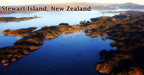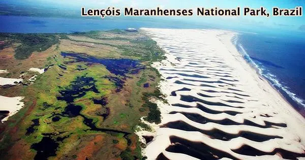
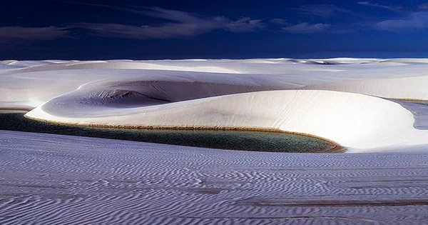
One of Brazil’s top natural attractions is the Lençóis Maranhenses National Park (Parque Nacional dos Lençóis Maranhenses), which is located in the state of Maranhão. The 155,000 ha (380,000 acre) park was declared protected on June 2, 1981. Its interior is made up of rolling sand dunes, and its 70 km (43 mi) of shoreline. Numerous thousands of dazzling blue lagoons are hidden beneath enormous sand dunes that cover 598 square kilometers. One of the most striking sandscapes in the world, with unearthly dunes only broken up by cerulean lagoons that dot the sandy hills between March and September, is also one of the least traveled.
Freshwater lagoons accumulate in the valleys between the sand dunes during the wet season because the impervious granite underneath prevents them from draining. The park has grown to be a well-liked destination for ecotourists and is home to a variety of species, including four that are categorized as endangered. It is an ecosystem formed of white dunes which cover 383,000 acres and look like bedsheets (lençóis in Portuguese) spread out on the Northeastern coast. As sand from riverbeds is dumped at river mouths and carried back to the continent by winds and sea currents over thousands of years, dunes are built.
A National Park, according to the Brazilian System of Protected Areas (BSPA) Law, has as its basic objective the preservation of natural ecosystems of great ecological relevance and scenic beauty, enabling scientific research and the development of environmental education activities, as well as recreation in direct contact with nature, such as ecological tourism (Federal Law 9.985/2000 – SNUC).
The park is surrounded by 70 kilometers (43 mi) of beaches along the Atlantic Ocean on Brazil’s northeastern coast in the state of Maranhão on the eastern coast. The Parnaba River, the So José Basin, the Itapecuru, Munim, and Periá rivers all form its internal borders. There are beaches between 600 meters and two kilometers wide, dunes between 10 and 20 meters high that form long, curving expanses of sand up to 75 kilometers in length, and more than 20 kilometers inland along the 80 kilometers of the park’s coastline.
The park is an ecosystem formed of white dunes which cover 383,000 acres and look like bedsheets (lençóis in Portuguese) spread out on the Northeastern coast. It encompasses an area of 155,000 hectares (380,000 acres), composed mainly of expansive coastal dune fields (composed of barchanoid dunes), which formed during the late Quaternary period. While much of the park has the appearance of a desert, the area receives about 1,200 millimetres (47 in) of rain per year, while deserts, by definition, receive less than 250 millimetres (10 in) annually. About 70% of this rainfall occurs between the months of January and May.
The park is situated in the Cerrado biome, but because of the Caatinga and Amazon ecosystems’ great influence, species from all three biomes can be found there. The river Preguiças originates in this area and flows through the Park to the Atlantic Ocean, where it empties into the river. The sand is carried to the park from the interior of the continent by the Parnaíba and Preguiças rivers, where it is then driven back inland up to 50 kilometres (31 mi) by winds, creating a series of sand dunes rising as much as 40 metres (130 ft) tall.
Lençóis Maranhenses National Park has a natural vegetation landscape that occupies predominantly the edges of its dunes. The vegetation is composed of restinga, mangrove and alluvial communities. The restinga is the predominant vegetation of the Park, representing 89.4%, while mangroves represent only 10.2% and alluvial communities (riparian forests) 0.4%. The dramatic scene that characterizes the protected area is the result of sedimentary deposits carried to the Atlantic Ocean by two rivers the Parnaíba and Preguiças which are subsequently driven back as far as 31 miles inland by high winds in dry season.
Despite appearances, Lençóis Maranhenses receives too much rainfall to be considered a desert. The freshwater lagoons, which can’t drain because of impervious rock beneath the sand, are actually formed by rain. Between July and August, the phenomena is usually at its most spectacular. A layer of impervious rock beneath the sandy surface of the lagoons prevents the water from draining. The lagoons typically have a temperature between 27.5 °C (81.5 °F) and 32 °C (90 °F), pH of between 4.9 and 6.2, and low levels of dissolved nutrients.
When the dry season returns, the pools quickly evaporate, losing as much as 1 metre (3 ft) of depth per month. The seasonal lagoons fill up with rainwater, mostly during the first six months of the year, giving Lençóis Maranhenses its unique landscape. Mangroves, deserted beaches, bursitis a graceful kind of palm tree and the Preguiças River also contribute to the park’s biodiversity.
Some of the lagoons at Lençóis Maranhenses National Park are huge. Lagoa Bonita and Lagoa Azul are near the town of Barreirinhas. Lagoa Tropical, also worth a visit, is closer to the village of Atins. Lagoa da Gaivota (Seagull Lagoon), one of the park’s largest and most beautiful, is near Santo Amaro do Maranhão, a village located about 60 miles from Barreirinhas.
One of the most known entrance portals for Lençóis Maranhenses is the city of Barreirinhas, 250 km away from São Luis, the capital of Maranhão. Well structured to welcome visitors, the city is surrounded by the dark waters of the river Preguiças named after the presence of the mammal sloth (Bradypus variegatus), «preguiça » in portuguese.
You can schedule a fly-over tour of the park from Barreirinhas for the best perspective, and if you want to explore additional dunes, you can plan a day excursion to Pequenos Lençóis, also known as Little Lençóis, which has a similar terrain but is much smaller. In the interior of the park are located two oases or restingas, Queimada do Britos, covering an area of 1,100 hectares (2,700 acres), and Baixa Grande, covering an area of 850 hectares (2,100 acres).
The area of the park has an average annual temperature of between 26 °C (79 °F) and 28.5 °C (83.3 °F) and an annual temperature variation of about 1.1 °C (2 °F). There are two isolated villages among the dunes. Caburé, 64 miles northeast of Barreirinhas, is little more than a sand peninsula between the river and the Atlantic ocean. Both the rivers that flow through the area and the lagoons in the park frequently connect to one another. Numerous fish and bug species live there, including the wolf fish, which hides in moist mud layers and goes dormant in the dry season.
The habitat also contains a region with restinga and mangrove ecosystems in addition to the dunes that serve as the park’s focal point. The proposal to create the Lençóis Maranhenses National Park (LMNP) was initially conceived to fill gaps in the so-called Brazilian System of Protected Areas, as well as to preserve samples of the diversity of natural ecosystems in the country, in order to ensure the continuity of evolutionary processes. Its objectives included addressing the requests of the scientific community and organizations working in the field of environmental protection in the State of Maranhão, as well as ensuring a diverse environment for future generations and environmental self-regulation.
The park is home to four species listed on the Brazilian List of Endangered Species, the scarlet ibis (Eudocimus ruber), the neotropical otter (Lontra longicaudis), the oncilla (Leopardus tigrinus) and the West Indian manatee (Trichechus manatus). The park also includes 133 species of plants, 112 species of birds, and at least 42 species of reptiles. The vegetation of the Park has the influence of three diverse and rich biomes, the Cerrado (savanna), the semi-arid Caatinga and the Amazon. In its 155 thousand hectares, it is home to diverse and fragile ecosystems, such as restinga (vegetation with marine influence), mangrove and dunes, the last ones being the main attraction of the National Park due to the lagoons formed during the rainy season.
There are no campgrounds or amenities in the park, so visitors spend the night in Barreirinhas and nearby towns. In this region, visitors can find basic accommodation like pousadas as well as more upscale hotels and resorts. The waterway, the most scenic entry route into Lençóis Maranhenses, is lined with mangroves, sand dunes and swaths of exotic palms (including acai, the Amazonian palmberries that make for one of Brazil’s tastiest treats).
Much of the territory of the Park is dominated by a landscape that cannot be found anywhere else on the planet: a succession of white sand dunes whose curves, when viewed from above, resemble large sheets stretched out in the wind. Lençóis Maranhenses National Park receives as many as 60,000 visitors a year. Common activities within the park include surfing, canoeing and horseback riding.