The Chatham Islands are a series of islands in the South Pacific Ocean about 500 miles (800 kilometers) east of New Zealand. Though the point (180°, 45°S) is around 173 miles WSW of the island’s westernmost point, it is considered to be “halfway between the equator and the pole, and squarely on the International Date Line.” The Chatham Islands, located over 800 kilometers from New Zealand, are a fascinating and distinctive element of New Zealand’s cultural, geographic, and natural heritage. On the island at one time, there were 26 distinct ethnicities.
In Moriori, the island is known as Rekohu (“misty skies”), while in Mori, it is known as Wharekauri. They are made up of ten volcanic islands, although portions of limestone indicate that they may have formerly been a part of New Zealand. It’s a secluded, awe-inspiring location with abundant birds and fascinating history that makes for a wonderful visit. The island was named after the survey ship HMS Chatham, which discovered the island for the first time in 1791.
It is 920 square kilometers in size (355 sq mi). Chatham Island is located 650 kilometers (404 miles) south-east of Cape Turnagain, the island’s closest mainland New Zealand point. Chatham Island, the biggest (347 square miles (900 square km)), rises to 942 feet (287 meters), with shallow lagoons covering more than 20% of its poorly drained terrain. Only Chatham and Pitt Islands are inhabited, and Te Whanga Lagoon on Chatham Island is larger than Rarotonga in the Cook Islands.
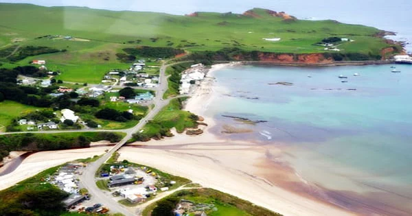
Tarakoikoia is a granite pinnacle rising suddenly to 566 feet to the southeast (172 metres). Three elements dominate the landscape of the approximately T-shaped island: two bays and a lagoon. The large depression of Petre Bay covers more than half of Chatham’s west shore. On Pitt Island, witness the Moriori rakau momori at the ancient and eccentric Maunganui Stone Cottage, the Basalt Columns and Splatter Rock, Glory Cottage and the Flowerpot Bay prison, and the Hapupu National Historic Reserve with 33 hectares of kopi forest (similar to tree carvings).
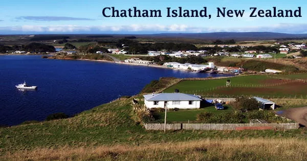
There are no native mammals, and the reptiles are all native to New Zealand. Since the introduction of Europeans, fires and grazing have severely altered the natural forest vegetation; significant parts are now covered in English grasses, while much of the rest is marsh, heath, and sand. Waitangi, the island’s largest village, is nestled in a tiny depression on Petre Bay’s southern shore. Kaingaroa on the northeast promontory and Owenga on the south side of Hanson Bay are two more notable communities.
Moriori descendants can still be found on the Chatham Islands today. A hospital, bank, shops, shipping wharf, and engineering and maritime services are all available on the Chatham Islands. The majority of guests arrive by flight, therefore it is strongly recommended that all visitors arrange lodging ahead of time. There is no cell phone coverage. Hanson Bay, on the island’s east coast, is much bigger, stretching the whole length of the island (35 kilometers, 22 miles).
The environment on this island is cold and humid, although the sun shines most days and the temperatures are comfortable. At times, it might be windy and freezing. The annual rainfall is over 1,000mm, however it mostly comes in the form of showers rather than severe downpours. The huge Te Whanga Lagoon, which drains to the sea to the east, into the southern half of Hanson Bay, takes up much of the space between the bays. This lagoon is 160 square kilometers (62 square miles) in size and drains many tiny rivers that originate in the island’s southern slopes.
Sealing and whaling stations sprung up quickly, with the latter lasting until 1861. Sheep were imported in 1865, and while the sector has been hampered by the islands’ remoteness, wool and breeding stock exports are now the mainstay of the economy.
Blue cod and crayfish from local waterways are further sources of income. There is an estimated 10,000 acres (4,000 hectares) of moorland peat that is being investigated for commercial use. Diesel generators and two wind turbines provide electricity. Shopping and dining choices on the Chatham Islands include a general store, petrol stations, hardware store, gift shop, art, and craft shop, gallery, lodge, hotel, and cafés.
Rangitahi and Huro, located northeast and southwest of Te Whanga, are the next two biggest lakes. The middle and northern parts of Chatham Island are generally flat, with heights varying from a few meters in the northeast to 50 meters in the northwest, with a few scattered hillocks. The population, which is mostly European but includes some Maori (who displaced the indigenous Moriori in 1835), is served by many schools and a hospital in Waitangi, Chatham Island’s main settlement.
The fish business is the island’s major source of revenue, and without it, the Chatham Islands’ people would have perished. Today, the focus is on long-term sustainability and the preservation of this resource for the local community and future generations. The only known breeding colonies of the rare and highly endangered Magenta petrel may be found on Chatham Island.