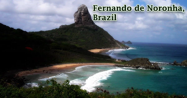
Fernando de Noronha (Portuguese pronunciation: feʁˈnɐ̃du d(ʒ)i noˈɾoɲɐ) is a Brazilian island located in the South Atlantic Ocean, 225 miles (360 kilometers) northeast of Cape So Roque. It is part of the Pernambuco estado (state). It is made up of 21 islands and islets that have a total area of 26 km2 (10 sq mi). The main island, which rises to a height of 1,089 feet (332 meters), covers 10 square miles (26 square kilometers) and is volcanic in nature.
Fernando de Noronha is technically the largest of a 21-island archipelago situated 525 kilometers (326 miles) northeast of Recife, Brazil. Only the main island, which has an area of 18.4 km2 (7.1 sq mi) and a population of 3,101 people in 2020, is inhabited. The Parque Nacional Marinho de Fernando de Noronha, Brazil’s first national park, encompasses much of the island, as well as all of the neighboring islands and seas. The islands are administratively distinct from the rest of Brazil.
The island was given to its Portuguese discoverer, Fernando de Noronha, in 1504 and eventually became a dependency of the Brazilian state of Pernambuco. The Saint Peter and Saint Paul Archipelago, approximately 625 kilometers (388 miles) northeast of Fernando de Noronha, is likewise within the authority of the state district. In 1988, a national marine park was formed covering 70% of the islands’ land area.
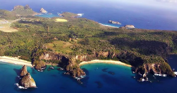
Giant shoals of fish dart about in silver, blue, or even bright green clouds. Rays and skates flit over the sand, turtles paddle serenely beneath the waves, and lemon and nurse sharks glide through the water in silence. Lion’s Beach, Atalaia Beach, and Sanchos Bay are the greatest of the island’s 16 beautiful beaches, while Rocas Atoll is ideal for rock pooling at low tide when the corals are exposed and the tidal pools teem with sea life. Because of its importance as a feeding place for tuna, sharks, turtles, and marine mammals, UNESCO recognized it as a World Heritage Site in 2001.
Those who are fortunate enough to visit the island are rewarded with a spectacular display of natural beauty, both on land and at sea. The rocky terrain of the island, which is part of a volcanic archipelago of 21 islands, contains towering rock sculptures, gushing waterfalls, and natural bathing pools. The archipelago was one of the earliest lands discovered in the New World, appearing on a nautical chart in 1500 by Spanish geographer Juan de La Cosa and in 1502 by Portuguese cartographer Alberto Cantino, with the name “Quaresma” in the latter.
According to the written record, Fernando de Noronha island was found on August 10, 1503, by a Portuguese voyage led by the Lisbon merchant Ferno de Loronha and planned and funded by a private commercial consortium. Baia do Porcos is a little beach, whereas Praia do Leo is the largest and wildest of the beaches. With visibility of up to 50 meters and water temperatures of 25 degrees all year, snorkeling and scuba diving are great.
Hundreds of spinner dolphins suddenly put on a show at dawn, skimming through the waves in close formation, their sleek grey bodies jumping and plunging. They got their name from the fact that they frequently breach from the water to spin wildly in the air like aquatic ballet dancers, even falling into somersaults in mid-flight. The main island is 18 km2 (6.9 sq mi) in size, measuring 10 km (6.2 mi) long and 3.5 km (2.2 mi) broad at its widest point. The base of this massive volcanic structure is 756 meters (2,480 feet) underground.
Basanite, nephelinite, and phonolite are among the lava types found in the volcanic rocks, which are all silica-undersaturated. Because of its strategic importance due to its proximity to Brazil, it was assaulted by naval forces numerous times in the 17th and 18th centuries, but the Portuguese were able to successfully defend it. The main island, from which the group receives its name, covers 91 percent of the entire area; the rest is made up of the islands of Rata, Sela Gineta, Cabeluda, and So José, as well as the islets of Leo and Viva. The Quixaba is the name of the main island’s central highland.
Sharks, dolphins, turtles, moray eels, and over 200 kinds of fish may all be seen at the island’s 30 dive sites, which include beautiful coral reefs, cliffs, and shipwrecks. The Noronha elaenia (Elaenia ridleyana) and the Noronha vireo are both indigenous to the islands (Vireo gracilirostris). Both species may be found on the main island, while the Noronha vireo can also be found on Ilha Rata.
Colorful fish, dolphins, lobsters, turtles, sponges, and corals abound in the seas near Fernando de Noronha, making it a popular diving and snorkeling spot. The archipelago is also a vital nesting ground for seabirds. Sea turtles, cetaceans (the most common of which are spinner dolphins and humpback whales, followed by a slew of others including pantropical spotted dolphins, short-finned pilot whales, and melon-headed whales), albatrosses, and a variety of other species are regularly seen.
Even experts believe that the island’s aquatic surroundings are a treasure: Fernando de Noronha is designated by the government as a marine ecological reserve. In the 18th century, the island was utilized as a penal colony, and some inmates are still transported there today. It was used as a monitoring station for US-guided missiles from 1957 until 1962. Tourism and recreational diving are encouraged on Fernando de Noronha’s beaches. Dive to depths of 30 to 40 meters (98 to 131 feet) without a wetsuit thanks to the South Equatorial Current, which brings warm water from Africa to the island. Underwater visibility can reach up to 50 meters (160 ft).
The seclusion of this 7-mile-wide island, along with the absence of visitors, has resulted in a tranquil getaway where swimming, diving, and trekking are popular activities. In 1988, the island was established as a national park, and in 2001, it was named a UNESCO World Heritage Site alongside the adjacent Rocas Atoll. Gov. Carlos Wilson Airport serves the island, with daily flights to Natal and Recife.
