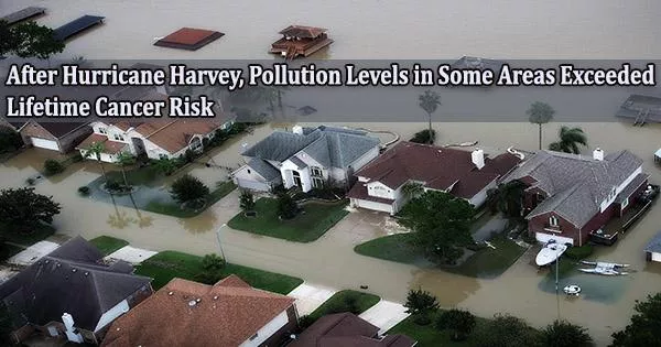
Southeast Texas suffered damage other than floods as a result of Hurricane Harvey’s record-breaking rainfall in 2017. Heavy rains and flooding may raise the risk of exposure to hazardous chemicals from surrounding industries for individuals living in environmental justice communities like the Manchester neighborhood near the Houston Ship Channel.
A research team led by Garett Sansom, DrPH, research assistant professor in the Department of Environmental and Occupational Health at the Texas A&M University School of Public Health, examined soil samples taken from the Manchester neighborhood soon after Hurricane Harvey to better understand how flooding mobilized pollution in the area.
The Journal of Health and Pollution just published the results. One week after Harvey, forty different areas throughout Manchester were visited by student and faculty researchers, members of Texas Environmental Justice Advocacy Services, and Manchester locals who were collecting soil samples.
The amounts of pollutants known as polycyclic aromatic hydrocarbons (PAHs), which are associated with adverse health consequences, including several types of cancer, were then measured in the samples by processing and analysis.
PAHs come from incomplete burning of hydrocarbons like wood and fossil fuels. They can be seen in large numbers next to industrial sites like shipyards and railroads, as well as major highways and other transportation hubs like oil refineries and other industrial facilities.
Additionally, PAHs bind to airborne particles, so after they land, floodwaters can shift them around. Due to the high baseline levels of PAHs in Manchester, residents are worried that flooding from hurricanes like Harvey could raise exposure risks.
Manchester is close to the Houston Ship Channel, a major interstate highway, a large railyard and several oil refineries. Previous studies have found that this neighborhood has a disproportionately high level of PAH pollution and associated health risks.
It is crucial to comprehend the effects of natural disasters such as flooding on the area. Residents in Manchester and other areas in the Houston region are growing more worried about flooding as the frequency of heavy rainfall events seems to be increasing.
Between 1981 and 2000, the odds of a rainfall event of more than 20 inches increased by one percent, and this frequency is expected to grow by 18 percent between 2018 and 2100. All 40 sample sites had different PAH concentrations, according to the investigation, with nine of the sites having PAH levels above the threshold that increases the risk of developing cancer. Nearly half of Manchester was also found to be to some extent contaminated.
The closest sites to the highway and the Houston Ship Channel had the highest amounts, whereas farther away sites had the lowest concentrations. The way flood waters passed through the area may have had some influence on the distribution of PAHs in Manchester.
For their analyses, the researchers lacked information on surface variations at street level. Thus, it is unknown how much the distribution pattern was influenced by non-absorbent surfaces like streets and sidewalks.
The results of this study add to earlier studies’ findings that people living in flood-prone locations may be more likely to be exposed to PAHs. This study also emphasizes the necessity of gaining a deeper comprehension of how PAHs distribute during flood occurrences.
Researchers, policy makers, and community leaders can assess the risks that people who live in communities that experience environmental injustice face and potentially find ways to reduce those risks in the future by using more data on baseline pollutant concentrations and better analysis techniques.