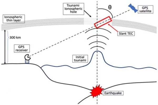
According to a new study led by UCL researchers, a new method for detecting tsunamis using existing GPS satellites orbiting Earth could serve as an effective warning system for countries worldwide. Although tsunami waves are typically only a few centimeters high, they cause a disturbance in the Earth’s upper atmosphere by pushing up air and creating an acoustic wave that is amplified as it rises.
This causes a change in the ionosphere 300km above the Earth’s surface, lowering the density of electrons in the area. This, in turn, has an effect on radio signals sent by GPS satellites to GPS receivers on the ground, delaying or speeding up different parts of the signal or changing its direction depending on frequency.
Researchers from UCL and universities in Japan developed a new method to detect this drop in electron density from altered GPS signals for the new study, which was published in Natural Hazards and Earth System Sciences.
Looking at GPS data at the time of the devastating 2011 Tohoku-Oki earthquake and tsunami, they found that a tsunami warning could have been issued with confidence within 15 minutes of the earthquake occurring — that is, at least 10 minutes prior to the first tsunami hitting Japan’s east coast. They also found that a warning could have been issued using data from only 5% of Japan’s 1,200 GPS receivers — meaning that the method could be used in countries with a sparser GPS network than Japan’s.
Our study, a collaborative effort between statisticians and space scientists, demonstrates a new low-cost method of detecting tsunamis that relies on existing GPS networks and could be implemented globally, complementing other methods of detecting tsunamis and improving the accuracy of warning systems.
Professor Serge Guillas
“Current tsunami warning systems are not as effective as they should be because they often cannot accurately predict the height of a tsunami wave,” said senior author Professor Serge Guillas (UCL Statistical Science and the Alan Turing Institute). The wave’s height was underestimated by Japan’s warning system in 2011. A better warning system could have saved lives and reduced the widespread destruction, allowing people to relocate to higher ground and away from the sea.
“Our study, a collaborative effort between statisticians and space scientists, demonstrates a new low-cost method of detecting tsunamis that relies on existing GPS networks and could be implemented globally, complementing other methods of detecting tsunamis and improving the accuracy of warning systems.”
Lead author and Ph.D. researcher Ryuichi Kanai (UCL Statistical Science and the Alan Turing Institute) said: “Our calculations suggest the size and shape of the wave could be inferred from the disturbance in the ionosphere and so the next step in the research will be to investigate this further to see if the method could be used for more precise predictions of tsunami size and range. From my experience of working for the Japanese government in the past and seeing the damage caused by the tsunami, I believe that if this research comes to fruition, it will surely contribute to saving lives.”
The researchers used statistical techniques to reconstruct the decrease in electron density in the atmosphere based on scattered points provided by GPS data, as well as to quantify the uncertainty inherent in the modeling.
The acoustic wave caused by the initial rise in the water took about seven minutes to reach 300km high in the ionosphere, and the subsequent decrease in electron density could be detected via satellite signals in 10 to 15 minutes, according to the researchers.
Tsunami waves are low in deep water but can travel at the speed of a jet (up to 800km/h in deep water) and grow in height as they enter shallower waters. Many existing tsunami warning systems infer tsunami waves from earthquakes, but this proposed method could be used to predict incoming tsunamis from sources other than earthquakes, such as landslides and volcanic eruptions.
While some tsunamis reach coastlines in less than ten minutes, the researchers noted that the method could also be used to predict second or third waves, assisting in determining whether a tsunami warning should be cancelled or maintained after the first wave.
The ionosphere extends from 48 km to 965 km above the Earth’s surface (the boundary between the Earth’s atmosphere and space). The Sun’s heat cooks the gases until they lose electrons (i.e. become ionised), resulting in a sea of charged particles containing an abundance of free electrons.