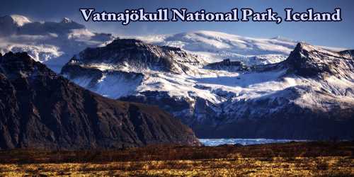
The second-largest national park in Europe is Vatnajökull National Park, which is one of three national parks in Iceland. It encompasses all of Vatnajökull glacier and extensive surrounding areas. These include the national parks previously existing at Skaftafell in the southwest and Jökulsárgljúfur in the north. It covers an area of 12,000 square kilometers (4,600 sq mi) and could be explored for weeks at a time.
The unique qualities of Vatnajökull National Park are primarily its great variety of landscape features, created by the combined forces of rivers, glacial ice, and volcanic and geothermal activity.
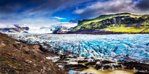
In general, national parks are protected areas. These areas are unique because of their nature or cultural heritage. The unique qualities of Vatnajökull National Park are primarily its great variety of landscape features. The national park is overflowing with the kind of stunning scenery people have come to expect from the “Land of Ice and Fire”. Here visitors can spend time hiking across Vatnajökull glacier or watch huge boulders of ice drift around the Jökulsárlón glacial lake. On 5th July 2019, Vatnajökull National Park was inscribed as a World Heritage Site.
History – Vatnajökull National Park was established on 7th June 2008. When established, the park covered an area of 12,000 km2, but with recent additions of Lakagígar, Langisjór, Krepputunga, and Jökulsárlón (including its surrounding areas) it now covers 14,141 km2 or approximately 14% of Iceland, making it Europe’s second-largest national park in terms of area after Yugyd Va in Russia.
Geography/geology and Climate – Vatnajökull National Park covers over 12.000 square kilometers (4.600 square miles) and covers more area than just the glacier itself, making this the largest Natural Park in Europe. Within the National Park visitors will find glaciers, glacial lagoons, volcanoes, hot springs, green and lush fields, lava fields, and black sand deserts. Generally measuring 400–600 m in thickness and at the most 950 m, the glacial ice conceals a number of mountains, valleys, and plateaus. It even hides some active central volcanoes, of which Bárðarbunga is the largest and Grímsvötn the most active. While the icecap rises at its highest to over 2,000 m above sea level, the glacier base reaches its lowest point 300 m below sea level. Nowhere in Iceland, with the exception of Mýrdalsjökull glacier, does more precipitation fall or more water drain to the sea than on the south side of Vatnajökull. In fact, so much water is currently stored in Vatnajökull that the Icelandic river with the greatest flow, Ölfusá, would need over 200 years to carry this quantity of water to the sea.
The scenery encircling the glacier is extremely varied. Towards the north, the highland plateau is divided by glacial rivers, with powerful flows in summer. The volcanoes of Askja, Kverkfjöll, and Snæfell tower over this region, together with the volcanic table mountain Herðubreið. Long ago, huge glacial floods carved out the canyon of Jökulsárgljúfur in the northern reaches of this plateau. The mighty Dettifoss waterfall still thunders into the upper end of this canyon, while the scenic formations at Hljóðaklettar and the horseshoe-curved cliffs of Ásbyrgi are found farther north.
Iceland includes the only part of the actively spreading Mid-Atlantic Ridge exposed above sea level, with the tectonic plates on either side moving apart by some 19 mm each year. This movement is accommodated in rift zones, two of which, the Eastern and Northern Volcanic Zones, pass through the property. Underneath their intersection is a mantle plume providing a generous source of magma. The property contains ten central volcanoes, eight of which are subglacial. Two of the latter are among the four most active in Iceland. Most of the property’s bedrock is basaltic, the oldest being erupted some 10 million years ago, and the most recent in 2015. Outside of the ice cap, the terrain varies from extensive, flat lava flows to mountains, including tuyas and tinder (ridges) of brown hyaloclastites, erupted in fissure eruptions beneath ice age glaciers. The latter occurs nowhere else in the world in such numbers.
The south side of Vatnajökull is characterized by many high, majestic mountain ridges, with outlet glaciers descending between them onto the lowlands. The southernmost part of the glacier envelops the central volcano Öræfajökull and Iceland’s highest peak, Hvannadalshnjúkur. Sheltered by the high ice, the vegetated oasis of Skaftafell overlooks the black sands deposited to its west by the river Skeiðará. These sands are mostly composed of ash which stems from the frequent eruptions at Grímsvötn and is brought to the coast by jökulhlaups, or glacial floods. Substantial volcanic activity also characterizes the landscape west of Vatnajökull, where two of the world’s greatest fissure and lava eruptions of historical times occurred, at Eldgjá in 934 and Lakagígar 1783-1784. Vonarskarð, northwest of the glacier, is a colorful high-temperature area and a watershed between North and South Iceland.
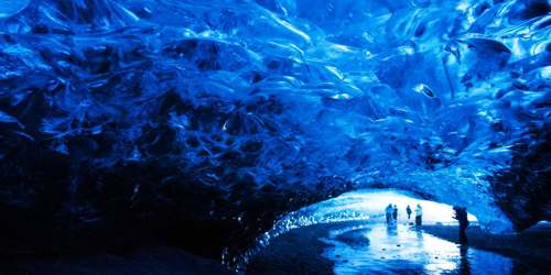
The blue color of thick ice is caused by ice reflecting the blue in the spectrum but absorbs the yellow and red color. This is true to all ice. However, in Iceland visitors will often see dark lines in the ice, which are caused by ash from erupting volcanoes. These lines can be used to date the ice and archaeologist in Iceland use the ash to date their findings and discoveries.
The weather can vary considerably in an area as extensive as that covered by the National Park with its wide range of elevations. In the mountains and on the ice cap itself, annual precipitation can reach to between 4,000 and 5,000 mm, for the most part in the form of snow. The depth of snow on Öræfajökull after a high-precipitation winter is between 10 and 15 m. Some of the snow will melt, while the rest forms glacial ice. This process happens everywhere above the snowline on the Vatnajökull ice cap. Temperatures on the southern part of the ice cap are almost always below zero in winter and can reach -20 °C or -30 °C. High winds and storms are common, and therefore wind-chill has to be taken into account as the wind can have a substantial effect on outdoor comfort, even when the ambient temperature is relatively high.
Operations and Services – The entirety of the Vatnajökull ice cap is protected, including countless outlet glaciers and glacial rivers. There are incredible rock formations around Ásbyrgi canyon, waterfalls such as Dettifoss and Svartifoss, the storied Lakagígar crater row, Askja, and other volcanoes of the highlands, and an unending variety of areas where geology, ecology and history lessons spring to life. Vatnajökull National Park has been nominated for inclusion on the Unesco World Heritage list.
Vatnajökull National Park is divided into four territories, each of them locally managed.
- The Northern Territory consists of north-western Vatnajökull, Askja caldera and its surroundings, Jökulsárgljúfur canyon and some of Jökulsá á Fjöllum riverbed. A visitor center and a campsite are located in Ásbyrgi, along with a campsite in Vesturdalur.
- The Eastern Territory includes Kverkfjöll mountains and north-eastern Vatnajökull, as well as the expanses of Snæfellsöræfi. A visitor center is located at Skriðuklaustur.
- The Southern Territory extends throughout the south-eastern part of Vatnajökull, or from Lómagnúpur mountain in the west to Lón and Lónsöræfi in the east. A visitor center and a campsite are located in Skaftafell. Information centers in co-operation with the national park are run in Höfn, Hoffell, Hólmur, and Skálafell.
- The Western Territory extends over the south-western part of Vatnajökull and a large area outside the glacier, including Lakagígar craters and Langisjór. An information center is located in Kirkjubæjarklaustur, jointly run by the national park and the local community.
The visitor center in Skaftafell is open all year round. The visitor centers in Ásbyrgi and Skriðuklaustur are open from the beginning of May throughout September but can be opened during winter on appointment. Most of the national park’s highland area is however inaccessible during the winter.
The Vatnajökull ice cap reached its greatest extent by the end of the 18th century and has on average been retreating since then. Recently, its retreat has accelerated in response to global warming, making the property a prime locality for exploring the impacts of climate change on glaciers and the landforms left behind when they retreat. The volcanic zones of the property hold endemic groundwater fauna that has survived the ice age and single-celled organisms prosper in the inhospitable environment of subglacial lakes that may replicate conditions on early Earth and the icy satellites of Jupiter and Saturn.
Information Sources: