New models that show how continents were formed are providing new insights into Earth’s history and will help provide a better understanding of natural hazards such as earthquakes and volcanoes.
“We looked at current knowledge of the configuration of plate boundary zones and the past construction of the continental crust,” said Dr. Derrick Hasterok, Lecturer, Department of Earth Sciences, University of Adelaide, who led the team that created the new models.
“The continents were assembled a few pieces at a time, much like a jigsaw puzzle, but once completed, the puzzle was cut up and reorganized to create a new picture. Our research illuminates the various components, allowing geologists to piece together the previous images. We discovered that plate boundary zones account for nearly 16% of the Earth’s crust and an even higher proportion of continents, 27%.”
Our work allows us to update maps of tectonic plates and continent formation found in school textbooks. These plate models, which were built using topographic data and global seismicity, have not been updated since 2003. We added more accurate information about the boundaries of deformation zones to further enrich the model: previous models showed these as discrete areas rather than wide zones.
Dr. Hasterok
The team produced three new geological models: a plate model, a province model, and an orogeny model. “There are 26 orogenies — the process of mountain formation — that have left an imprint on the present-day architecture of the crust. Many of these, but not all, are related to the formation of supercontinents,” said Dr. Hasterok.
“Our work allows us to update maps of tectonic plates and continent formation found in school textbooks. These plate models, which were built using topographic data and global seismicity, have not been updated since 2003.”
Several new microplates are included in the new plate model, including the Macquarie microplate, which is located south of Tasmania, and the Capricorn microplate, which separates the Indian and Australian plates.
“We added more accurate information about the boundaries of deformation zones to further enrich the model: previous models showed these as discrete areas rather than wide zones,” Dr. Hasterok explained.
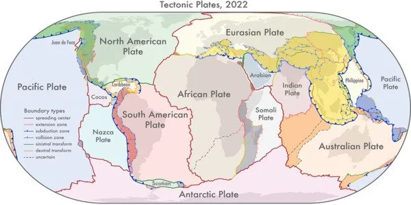
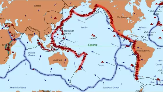
“The most significant changes to the plate model have occurred in western North America, where the boundary with the Pacific Plate is frequently drawn as the San Andreas and Queen Charlotte Faults. However, the newly delineated boundary is approximately 1500 km wider than the previously drawn narrow zone. Another significant shift is occurring in Central Asia. As the plate bulldozes its way into Eurasia, the new model now includes all of the deformation zones north of India.”
The team’s work, which was published in the journal Earth-Science Reviews, provides a more accurate representation of the Earth’s architecture and has other significant implications. Earth Architecture is a field of study that focuses on the architectural uses of the earth in shaping humankind’s environment, a topic that is closely related to human ecology. Earth Architecture includes examples from various cultures and time periods, both modern and historical. Earthen structures currently house an estimated 1.5 billion people, or approximately 30% of the world’s population.
“Our new tectonic plate model better explains the spatial distribution of 90% of earthquakes and 80% of volcanoes from the last two million years, whereas existing models only capture 65% of earthquakes,” Dr Hasterok said.
“The plate model can be used to improve models of geohazard risk; the orogeny model can be used to better understand geodynamic systems and model Earth’s evolution; and the province model can be used to improve mineral prospecting.”