Seamounts are underwater mountains that rise from the ocean floor and can provide important insights into a variety of geological processes. While most seamounts are extinct volcanoes, some are still active or have recently erupted. A sinking seamount can provide information about a fascinating phenomenon known as slow-motion earthquakes.
The first 3D seismic imaging of a sub-ducting seamount off the coast of New Zealand reveals a previously unknown sediment trail in the Earth’s crust. Scientists believe the sediment patches aid in the gradual release of tectonic pressure in slow slip earthquakes rather than violent tremors. The findings will aid researchers in their search for similar patterns at other subduction zones, such as Cascadia in the United States Pacific Northwest.
Scientists have long wondered what happens when seamounts (seafloor mountains and volcanoes) are dragged into subduction zones. According to new research from The University of Texas at Austin, when seamounts sink, they leave a trail of soft sediments behind. The sediment patches, according to the researchers, help tectonic pressure escape gradually in slow slip earthquakes rather than violent tremors.
The findings, which were published in the journal Nature Geoscience, can be used to modify earthquake models and aid scientists in understanding the mechanisms that cause earthquakes.
There may be other places with sub-ducting seamounts and a lot of sediment, such as Cascadia (in the United States Pacific Northwest), but because the sub-ducting crust there typically has less water than Hikurangi, they may be less likely to have the same kind of shallow slow slip activity.
Nathan Bangs
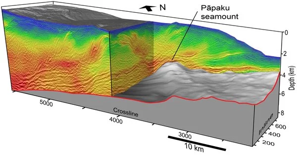
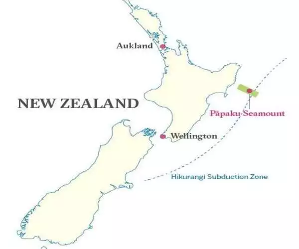
Nathan Bangs, a senior research scientist at the University of Texas Institute for Geophysics, led the study. Bangs led an ocean seismic survey in 2018 that yielded the first 3D scan of a large sub-ducting seamount. The long-extinct volcano, known as the Ppaku Seamount, lies three miles beneath the seafloor inside the Hikurangi subduction zone off the coast of New Zealand.
The scan images show the seamount colliding with the subduction zone, as well as the pattern of stresses, fluids, and sediments that surround it. Previous models predicted that sediments are pushed down the subduction zone ahead of the seamount, but the scan revealed the opposite: a massive sediment trail in Ppaku’s wake.
In another surprise, the scientists spotted the fading trail of a much larger seamount that had long since sunk beneath New Zealand’s North Island.
Bangs believes that sinking seamounts drag down enough water-rich sediment to create conditions in the crust conducive to slow slip earthquakes, at least in New Zealand.
“That older one seems to be very much linked to an uplifted ridge that’s really in the bullseye of where recent slow slip activity has been,” Bangs said. “There may be other places with sub-ducting seamounts and a lot of sediment, such as Cascadia (in the United States’ Pacific Northwest), but because the sub-ducting crust there typically has less water than Hikurangi, they may be less likely to have the same kind of shallow slow slip activity.”
Slow slip earthquakes are slow motion versions of large earthquakes that release similar amounts of pent-up tectonic energy but in a harmless creeping manner that can take days or weeks to unfold. Scientists believe that the composition of the crust plays a significant role in the release of tectonic energy, with softer, wetter rocks allowing plates to slip slowly and drier, brittle rocks storing energy until they fail in violent and deadly megaquakes.
The new findings reveal how those conditions can occur and, more importantly, tell scientists what to look for in the world’s other subduction zones, according to Bangs.