The Florida coast is expected to be slammed by Hurricane Ian later today, September 28. The National Weather Service (NWS) has upgraded its storm warning to a strong category 4 due to concerns regarding gusts exceeding 250 kilometers per hour (155 miles per hour). They also issued warnings of potentially deadly tornadoes, devastating floods brought on by heavy rain, and life-threatening storm surges.
According to the most recent NOAA public alert, the center of Ian is anticipated to make landfall on Florida’s west coast this afternoon just south of Tampa. It is expected to move northward tonight over central Florida and Thursday early before emerging late on Thursday over the western Atlantic.
When Ian seemed like it would become a category 3 hurricane and make landfall in Florida, almost 2.5 million individuals were instructed to gather their possessions and leave their houses. With the threat now at category 4, several areas of the state are already facing flooding and power disruptions.
“Some communities in Florida have been ordered to evacuate due to a potentially fatal storm surge along the west coast of the state, one of many anticipated threats from Hurricane Ian. I implore those citizens to follow the authorities’ instructions! These difficult choices are driven by your safety, NWS Director Ken Graham stated in a tweet on Monday.
A small number of Floridians, however, have opted to disregard the warnings and remain in their homes. This includes those with mobility concerns who are disabled, those who cannot afford to go, and the brave few who have stayed to assist others, according to NPR.
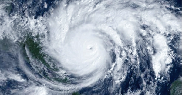
Any of the satellite images will demonstrate how serious this storm is. Hurricane Ian originated in the Atlantic Ocean, close to the Caribbean Windward Islands, where it was first discovered. It strengthened as it made its way into the Caribbean Sea and sliced northward.
Yesterday, it reportedly brought persistent gusts of 205 kilometers per hour (125 miles per hour) to Cuba’s west coast, which destroyed significant portions of the nation’s electrical grid. It just got stronger as it traveled up into the Gulf of Mexico.
In addition to the destruction that Hurricane Ian is expected to bring, the storm also interfered with the launch of the eagerly awaited Artemis I mission to the Moon. Originally slated for September 3, the launch has had multiple difficulties over the past month. Last Monday, NASA cancelled its September 27 Artemis launch.