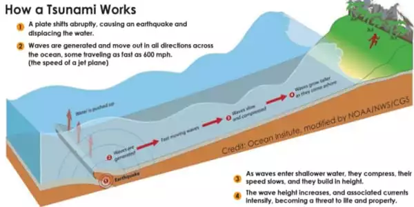
The Earth’s surface is made up of tectonic plates, which are enormous solid rock slabs that fit together like jigsaw pieces. These plates collide at plate boundaries and are constantly in motion. Stress builds up where the surfaces of these plates catch and lock at their boundary as the rest of the plates continue to move. This happens over a long period of time. When the stress grows too severe, the plates abruptly slip past their other, releasing enormous amounts of energy and causing the earth to quake and shatter. These fissures are known as faults. Many faults make up plate borders. The majority of earthquakes occur on these faults.
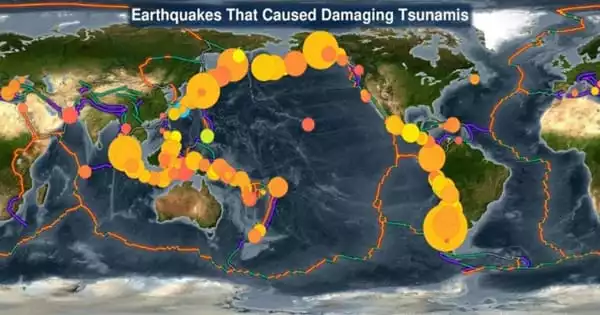
Tsunamis can be caused by earthquakes on any of these faults, but the most, and the greatest, are caused by earthquakes on reverse faults. These tsunami-causing earthquakes primarily occur in subduction zones, where two tectonic plates meet and one is thrust beneath the other.
Tsunamis of differing sizes can be caused by earthquakes of similar magnitude. This widely seen but poorly understood phenomena has hampered credible local tsunami warnings. This study offers new insight into the relationship between earthquake features – magnitude, depth at which two tectonic plates slip past one other, and the rigidity of the plates involved – and the probable size of a consequent tsunami.
Scientists at the University of Hawai’i at Manoa have discovered a new link between the features of earthquakes – magnitude, depth at which two tectonic plates slip past each other, and the rigidity of the plates involved – and the potential size of a consequent tsunami.
Earthquake and tsunamigenic processes are complex, including numerous elements that differ from one occurrence to the next. We used a simplified numerical model to identify important earthquake factors and assess their significance in determining tsunami size.
Professor Thorne Lay
Previous research found a subset of occurrences known as tsunami earthquakes, which generate unusually big tsunamis for their magnitude. Kwok Fai Cheung, professor of Ocean and Resources Engineering in the UH Manoa School of Ocean and Earth Science and Technology (SOEST), Thorne Lay from the University of California — Santa Cruz, and co-authors solved the mystery. Their findings were just published in Nature Geoscience.
The team used computer models to combine physical processes that cause earthquakes and tsunamis with a wide range of observations of real-world events, including tsunami earthquakes. The model results showed that for a given earthquake magnitude if the rupture extends to a shallow depth in the less rigid part of the plate, the resulting tsunami is larger than if the rupture extends to a deeper depth.
“The higher plate in a subduction zone is thinner and less stiff than the underthrusting plate near the trench,” Cheung added. “A concentrated near-trench or shallow rupture produces relatively moderate ground shaking as measured by seismometers, but the displaced water in the overlying deep ocean has greater energy and produces shorter tsunami waves that amplify rapidly as they approach the beach.”
“Earthquake and tsunamigenic processes are complex, including numerous elements that differ from one occurrence to the next,” said Lay, a UC Santa Cruz professor of Earth and Planetary Sciences. “We used a simplified numerical model to identify important earthquake factors and assess their significance in determining tsunami size.”
After confirming that the presence of shallow earthquake rupture can be a more relevant component than earthquake magnitude for the following tsunami size, the researchers raised an essential question: Can earthquake magnitude be utilized as the primary indicator of probable tsunami impacts?
“The approach of estimating potential tsunami hazard using earthquake magnitude has resulted in poor predictive capability for tsunami impacts, and more information about the source is necessary to do better,” Cheung added.
The use of skills in seismology, with Lay, and tsunamis, with Cheung’s research group, to a huge set of observations is an important part of this interdisciplinary research. This work encourages the development of novel seismological and seabed geodesy studies that can identify shallow ruptures quickly in order to obtain more reliable tsunami warning.
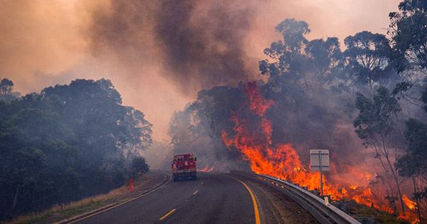
While shorelines throughout the Pacific Ocean and throughout the “Ring of Fire” are vulnerable to tsunamis, the situation is particularly dire for coastal cities near the earthquake, where the tsunami arrives swiftly – especially when comprehensive information about the earthquake is not yet accessible.
Cheung and Lay’s collaboration on prehistorical, historical, and future tsunami incidents continues in order to better comprehend the threats posed to coastal towns and enable more accurate warning systems.