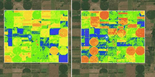
Satellite crop monitoring has resulted in many developments in the agricultural industry. It is the technology that facilitates real-time crop vegetation index monitoring via spectral analysis of high-resolution satellite images for different fields and crops which enables tracking of positive and negative dynamics of crop development. The use of satellite data and online analytical services are able to fill the gaps in the routine audit methods. They allow you to quickly get and assess information on any field. The difference in vegetation index informs about single-crop development disproportions that speak for the necessity of additional agriculture works on particular field zones—that is because satellite crop monitoring belongs to precision agriculture methods. With all the best planning, recommendations, and crop management practices, there’s still nothing that replaces empirical, on-farm data. Among many other uses, satellite monitoring is suitable for the precise weather forecasts on your farm location based on concrete field coordinates.
“Satellite crop monitoring technology allows performing online crop monitoring in different fields, located in different areas, regions, even countries, and on different continents.”
The key advantage of satellite imagery is that its data is at different spectral, spatial, and temporal resolutions for crop assessment, crop health, agriculture, crop change detection, irrigated landscape mapping, environmental analysis, yield determination, and soils analysis. Satellite crop monitoring technology allows performing online crop monitoring in different fields, located in different areas, regions, even countries, and on different continents. Crop Monitoring is a universal tool for all the players of the agro market as you can find the field health monitoring, climate impact analysis, fertility management, and crop yields modeling tools at one-for-all Platform. The technology’s advantage is a high automation level of sown area condition and its interpretation in an interactive map that can be read by different groups of users. Apart from highlighting problematic areas, satellite images can assist in monitoring the effectiveness of applied preventive and any corrective actions that a farmer can choose to implement. The reason why images are valued is that they act as early indicators of crop stress or projected yield.
The satellite crop monitoring system allows a user to monitor crops that are in different fields, regions, and areas. After monitoring, the system performs an analysis of the different fields monitored and also an interpretation of the analyzed data for the various users.
Satellite crop monitoring technology users are:
- agronomists and agriculture companies management (crop vegetation control, crop yield forecasting, management decisions optimization);
- business owners (business prospects estimates, making reasonable decisions on capital investments, providing information for management decisions);
- investors and investment analysts (investment potential estimation, making investment decisions, making sustainable forecasts);
- agriculture machinery producers (integration of crop monitoring solutions with agriculture machinery board computers operations, functional development);
- state and sectoral organizations engaged in agriculture, food security, and ecological problems.