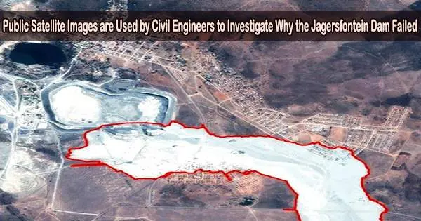
In the town of Jagersfontein in the South African province of the Free State, a tailings dam that was used to store waste from diamond mines collapsed on September 11, 2022. One individual died and several residences were destroyed in the failure.
The remaining, finely powdered material that is left over after valuable metals are extracted from rock ore is known as tailings. Typically, tailings are conveyed with water and then dumped in a tailings dam for storage.
Now, six months later in 2023, civil engineers at the University of the Witwatersrand, Johannesburg (Wits), have used public satellite and aerial imagery in a study to investigate the history of the Jagersfontein dam.
Satellite images show what went wrong
The Sentinel-2 and Landsat 8 satellite missions, as well as Google Earth Pro, were used as sources for the study’s public satellite pictures. Additionally, a few of the failure’s immediate effects were evaluated using commercial satellite pictures.
Dr. Luis Torres-Cruz and Mr. Christopher O’Donovan in the School of Civil and Environmental Engineering at Wits authored the paper which was published in the journal Scientific Reports on 5 April 2023.
The analysis discovered that the Jagersfontein dam’s history departs from ideal engineering procedure. Along with erosion gullies on the dam wall and substantial amounts of ponded water occasionally positioned up against the retaining structure, the deviations include mine waste deposition from mostly one side of the dam.
According to the study’s theory, instability was finally brought on by water percolating through the dam, followed by exterior erosion.
“We expect our paper to be useful to those interested in understanding how this tragic event came to be and also to help prevent future failures,” says Torres-Cruz, corresponding author and a Senior Lecturer in the School of Civil and Environmental Engineering, who specialises in geotechnical aspects of tailings dams.
O’Donovan, study co-author and a Wits Master’s candidate interested in efficient engineering practices and creating access to information, adds: “The fact that our study relies on publicly available data to investigate the history of the dam implies that anyone can independently verify our observations.”
Assessment of consequences
Torres-Cruz and O’Donovan used two high-resolution satellite photos to show the harm done to the nearby residential areas in order to evaluate the impact and implications of the dam failure.
Between four and six million cubic meters of mining waste were spilled, according to the scientists’ calculations based on a three-dimensional model of the broken dam.
The study also includes an animation that illustrates the post-failure geometry. Additional satellite imagery shows that the mine waste travelled 7km over dry land and 56km along streams and rivers to reach the reservoir of the Kalkfontein dam.
Outlook
The study mentions some free and comparatively simple sites for viewing satellite imagery that were used in the analysis. In light of this, these platforms can enable stakeholders to use open-source satellite images as a starting point for proactive tailings dam monitoring when combined with knowledge on tailings dams.
The research also implies that better adherence to good construction standards may be prompted by more knowledge of the potential of open-source satellite images.
The report emphasizes that a thorough monitoring plan for tailings dams should concentrate on their proper design and maintenance. It also highlights how crucial it is to carry out a formal, impartial site assessment in order to comprehend the failure sequence and the circumstances that contributed to it.