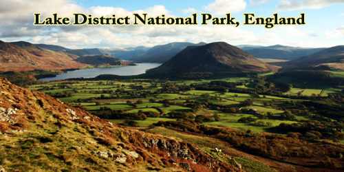
The Lake District National Park is one of the most famous national parks in Europe. It is a national park in North West England that includes all of the central Lake District, though the town of Kendal, some coastal areas, and the Lakeland Peninsulas are outside the park boundary.
The park is considered one of England’s most scenic regions and is the country’s premier destination for hiking and climbing. The park lies entirely within the modern county of Cumbria, shared historically by the counties of Cumberland, Westmorland, and Lancashire. Known as much for its mountain peaks (called fells) as its lakes, the park is home to England’s tallest mountain, Scafell Pike, and its largest lake, Windermere.
As its name suggests, this national park in northwest England is defined by the picturesque lakes that dot the landscape. It’s home to Wast Water, England’s deepest lake, as well as Windermere, the country’s largest lake. But there’s more to the Lake District than just water. The park’s endless lakes are broken up by stunning valleys and quaint villages, all of which sit in the only part of England above 3,000 ft.
The area was designated a national park on 9th May 1951 (less than a month after the first UK national park designation the Peak District). It retained its original boundaries until 2016 when it was extended by 3% in the direction of the Yorkshire Dales National Park to incorporate areas such as the land of high landscape value in the Lune Valley.
It is the most visited national park in the United Kingdom with 16.4 million visitors per year and more than 24 million visitor-days per year, the largest of the thirteen national parks in England and Wales, and the second largest in the UK after the Cairngorms National Park. Its aim is to protect the landscape by restricting unwelcome change by industry or commerce. Most of the land in the park is in private ownership, with about 55% registered as agricultural land.
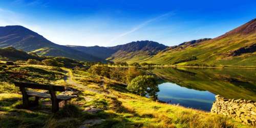
The Lake District comprises 16 lakes, 53 tarns, and several “waters”. All possess their own unique features and provide a comforting sense of permanence, standing as they do, framed by glorious backdrops of mountains, fells, and woodland. Despite the name the “Lake District” there is only one body of water that carries the name “lake” – Bassenthwaite; all the rest are “waters” and “meres”.
- Bassenthwaite Lake
- Buttermere
- Coniston Water
- Crummock Water
- Derwent Water
- Elterwater
- Ennerdale Water
- Esthwaite Water
- Grasmere
- Haweswater
- Loweswater
- Rydal Water
- Thirlmere (now a reservoir with limited access)
- Ullswater
- Wast Water (England’s deepest lake)
- Windermere (England’s largest lake)
The Lake District is home to England’s highest peaks, and Scafell Pike tops the list at 3,210 feet (978 meters). These mountains, known locally as “fells,” may be modest compared with the world’s great ranges but their beauty is certainly worthy of lofty standing.
According to the most respected authority (guidebook author A. Wainwright), there are 214 fells, most of which offer a number of routes, plus many opportunities to ridge-walk between the fells.
The highest is Scafell Pike (pronounced “Scaw-fell”). This “highest” designation leads to a lot of traffic, and visitors who want to experience a high Lakeland Fell may want to choose another. Some of the slightly smaller fells are in fact much more rewarding to climb as well as offering better views. Great Gable and Helvellyn are popular choices. Less well-known hills include Grisedale Pike, Fairfield, and Bowfell.
The National Park Authority is based at offices in Kendal. It runs a visitor center on Windermere at a former country house called Brockhole, Coniston Boating Centre, and Information Centres. It is reducing its landholding.
In common with all other national parks in England, there is no restriction on entry to or movement within the park along public routes, but access to cultivated land is usually restricted to public footpaths, bridleways, and byways. Much of the uncultivated land has statutory open access rights, which cover around 50% of the park.
The Lake District boasts a rich cultural heritage that spans the centuries from prehistoric times to the present day. More than 6,000 archaeological sites and monuments are listed, including 5,000-year-old stone circles, Roman roads, and classic country estates. More than 40,000 people live in the Lake District, and they cherish some unique cultural traditions. Men lock horns in Cumberland and Westmorland wrestling, which dates to the Viking era, and dogs are turned loose to compete in long-distance “hound trailing” runs along a trail of scented aniseed. The local fare is also especially appetizing, from Cumberland sausage to rum butter and the plum-like damson fruit.
The National Park features an extensive network of footpaths throughout the valleys and on the fells (the local term for mountains), allowing excellent access. Surprise View in Borrowdale, with views over Derwentwater, Keswick, and Skiddaw.
Farmland, settlement, and mining have altered the natural scenery, and the ecology has been modified by human influence for millennia and includes important wildlife habitats. Having failed in a previous attempt to gain World Heritage status as a natural World Heritage Site, because of human activities, it was eventually successful in the category of the cultural landscape and was awarded the status in 2017.
Information Sources:
