Geoinformatics is one of the powerful technologies to support basic scientific inquiry as well as address the complex social and environmental challenges through data analysis. It is the science and the technology which develops and uses information science infrastructure to address the problems of geography, cartography, geosciences, and related branches of science and engineering. It is based on the principle of geocoding which involves converting geographic data into images in form of a map. It is a rapidly growing industry as digitization is taking over the world.
Geoinformatics is the geographical information stored in layers. The information is integrated with geographic software in order to create, store, and manipulate spatial information.
Overview
Geoinformatics consists of remote sensing, geographic information system, global navigation satellite system, and information technology to create spatial infrastructure. It has been described as “the science and technology dealing with the structure and character of spatial information, its capture, its classification and qualification, its storage, processing, portrayal, and dissemination, including the infrastructure necessary to secure optimal use of this information” or “the art, science or technology dealing with the acquisition, storage, processing production, presentation and dissemination of geoinformation”. This industry is interconnected to many other industries that use spatial information and data for various purposes.
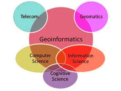
The technology which builds the infrastructure to cater to solve the location-based business issues and other areas of science and engineering through Information Science is known as Geoinformatics. It is a similarly used term that encompasses geoinformatics, but geomatics focuses more so on surveying. It uses technologies that facilitate the procedure of attaining, visualizing, and analyzing geospatial data. Geoinformatics has at its core the technologies supporting the processes of acquiring, analyzing, and visualizing spatial data. It collects and organize the data and then analyzes it through computation and geo-visualization.
Geoinformatics covers a wide range of sectors such as agriculture, national security, defense, forestry, irrigation, infrastructure development, climate change, urban planning, meteorology, oceanography, telecommunications, public health, etc. Geography and earth science increasingly rely on digital spatial data acquired from remotely sensed images analyzed by geographical information systems (GIS), photo-interpretation of aerial photographs, and Web mining.
Geoinformatics research involves using modern information methods and technologies, application programs, databases, the internet, and software development constitute the foundation for the deployment of Geoinformatics. Geoinformatics combines geospatial analysis and modeling, development of geospatial databases, information systems design, human-computer interaction, and both wired and wireless networking technologies. The realm of Geoinformatics is very broad because it comprises subjects like Remote sensing, GPS, GIS, cartography, hydrology, climatology, Aerial photography, photogrammetry, etc. Geoinformatics uses geocomputation and geovisualization for analyzing geoinformation.
Information Source: