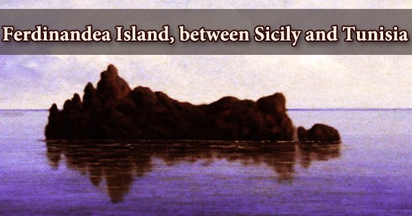
Ferdinandea island (also known as Graham Island, Graham Bank, or Graham Shoal; French: Ile Julia), is a submerged volcanic island 30 kilometers southwest of Sicily that formed part of the massive underwater volcano Empedocles (37°10 N, 12°43 E). It’s a huge rocky platform in the Sicilian Channel between Sciacca and Pantelleria, about 6 meters below the water’s surface. In the shelf sea between Sicily and Tunisia, a new volcanic island arose above sea level in mid-July 1831. The island’s summit is currently 20 feet below sea level.
The island’s most recent “appearance” was in July of 1831, but by January of 1832, the wind and waves of the Mediterranean Sea had completely swept away the section of the island above sea level. On July 17, 1831, Sicilian customs officer Michele Fiorini visited the island for the first time, planting an oar to claim the freshly formed island for the Kingdom of Sicily. Molten lava, volcanic gases, and pumices were thrown from the crater. The new volcano island grew to a size of around 400 × 250 m2 (=0.1 km2) during the following several weeks.
The volcano’s greatest height approached 60 meters. The unexpected arrival sparked a complex international dispute about the sovereignty of this new territory. However, since the island vanished beneath the seas in December of that year, the matter has remained unsolved. Humphrey Fleming Senhouse, commander of the first grade Royal Navy ship of the line St Vincent, named the island after Sir James Graham, the First Lord of the Admiralty, and claimed it for the United Kingdom on August 2, 1831. During the island’s brief 6-month existence, a four-way dispute over the island’s sovereignty emerged in 1831, which remained unresolved when the island vanished beneath the seas again in early 1832.
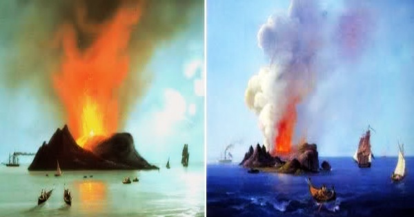
Ferdinandea Island’s tale began in July of 1831. It began with a series of shakes and a strong sulphur odor. Clearly, a volcano was exploding someplace. That’s nothing out of the ordinary. Sicily is a volcanic island, and the locals are used to large and minor eruptions. On the other hand, there were no evidence of a volcanic explosion elsewhere on the island. The island is part of the underwater volcano Empedocles, which is one of a group of undersea volcanoes known as the Campi Flegrei del Mar di Sicilia and is located 30 kilometers (19 miles) south of Sicily. It has been elevated above sea level numerous times by seamount eruptions before being re-submerged by erosion.
It grew to a height of 63 meters and a diameter of 4.8 kilometers. On the northeastern side, there was a peak with a plain in the middle, where two tiny ponds had developed, one of which was 20 meters in diameter and 2 meters deep. Some analysts speculated at the time that a chain of mountains might form, connecting Sicily and Tunisia and so disrupting the region’s geopolitics. It displayed evidence of volcanic activity in 2000 and 2002, indicating that it may appear; nevertheless, it is still 6 m (20 ft) below sea level as of 2016.
Tephrite, an eruptive rock type that is easily eroded, made comprised the majority of the island. As a result, it didn’t take long for the sea waves to totally disintegrate. During the First Punic War in the 3rd century BC, volcanic activity on Ferdinandea Island was first noted. Since then, the island is thought to have emerged and vanished four or five times. Since the 17th century AD, many eruptions have been documented. The large block of granite had formed at a strategic place near the Mediterranean’s major shipping routes, and every nation with a naval presence in the area knew that whomever claimed the island would have complete control over all commercial and military maritime movement through the area.
The island is situated in the Mediterranean Sea, between Sicily and Tunisia, in a volcanic region known as the Campi Flegrei del Mar di Sicilia (Phlegraean Fields of the Sea of Sicily). There are several underwater volcanoes (seamounts) in the area, as well as volcanic islands like Pantelleria. The island vanished completely in January 1832. The brief lifespan of this piece of land did not prevent the sovereigns of the time from claiming it as their own. In 1863, further eruptions forced the island to resurface momentarily before sinking below sea level once more.
It measured 4,800 m (15,700 ft) in diameter and 63 m (207 ft) in height at its peak (in July and August 1831). It had two tiny lakes, the biggest of which had a radius of 20 meters (66 feet) and a depth of 2 meters (6 feet 7 inches). The island’s volcanic composition was so fractured and fragile that it was unable to withstand the onslaught of the ocean waves. The sea quickly eroded it away when the eruption ended. The oldest mentions of submarine activity on the island date back to the First Punic War.
It reappeared and vanished several times during the seventeenth century, only to reappear for little periods of time. The island had a conical shape while it was above sea level owing to its volcanic activity; as a result of the latter, its surface was stony and created from remnant debris from various eruptions. The tiny volcanic point, which was closer to Spain and Italy than Malta, was a key strategic position in the Mediterranean for the world’s leading naval force at the time. Surprisingly, regardless of how uncommon the creation of a new volcano was, European politicians were the first to show an interest in the subject, even before naturalists.
The island reappeared in 1863, this time due to a new eruption, before sinking back into the sea. Ferdinandea Island, also known as Graham Island, has been lying 8 meters below sea level since then, within scraping reach of a ship’s hull. Ships are aware of its presence, but for those unfamiliar with the area, the submerged island may appear to be a concealed danger. The volcano was inactive for several decades after 1863, with its top just 8 meters (26 feet) below sea level. In the year 2000, increased seismic activity around Ferdinandea island prompted volcanologists to predict that a fresh eruptive episode may be on the way, and the seamount could revert to its former status as an island.
The island resurfaced on the surface in 1846 and 1863, only to vanish again after a few days. Following the international conflict, just a few names remain: Giulia, Nerita, Corrao, Hotham, Graham, Sciacca, Ferdinandea. The island was given the name Ferdinandea by the Sicilians to honor their monarch. If the old island reappeared, Italian sailors placed an Italian flag on top of the bank to prevent other nations from claiming it. Despite showing signs of seismic activity in both 2000 and 2002, the seismicity did not result in volcanic eruptions, and Ferdinandea’s summit remains about 8 meters (26 feet) below sea level as of 2006.
On his route to attack Libya in 1987, an American pilot mistook the submerged peak for a submarine and fired depth charges on the island. The National Institute of Geophysics and Volcanology has discovered that “Ferdinandea” is part of a complex system of underwater volcanoes. The island is one of the accessory cones of the underwater volcano Empedocle, a massive volcanic structure with many similarities to Etna, Sicily’s most famous volcano. If the island reappears in the near future, there is unlikely to be a big territorial conflict over it, given the island now does not have the same strategic value as it did in 1831.
Information Sources:
