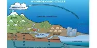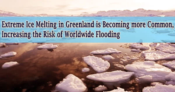
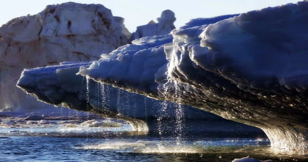
According to a recent study, global warming has caused catastrophic glacier melting episodes in Greenland to grow more frequent and violent over the last 40 years, elevating sea levels and flood danger throughout the world.
3.5 trillion tonnes of ice have melted off the island’s surface and poured downhill into the ocean in the last decade alone. That’s enough melted ice to cover the whole United Kingdom in 15 meters of meltwater or to cover New York City in 4500 meters.
The new research, which was headed by the University of Leeds, is the first to utilize satellite data to identify ice sheet outflow from space. Greenland’s meltwater flow has increased by 21% over the last four decades and has grown 60% more irregular from one summer to the next, according to the results published in Nature Communications.
Lead author Dr Thomas Slater, a Research Fellow in the Centre for Polar Observation and Modelling at the University of Leeds said:
“As we’ve seen with other parts of the world, Greenland is also vulnerable to an increase in extreme weather events. As our climate warms, it’s reasonable to expect that the instances of extreme melting in Greenland will happen more often observations such as these are an important step in helping us to improve climate models and better predict what will happen this century.”
The research employed data from the European Space Agency’s (ESA) CryoSat-2 satellite mission, which was sponsored as part of the Polar+ Surface Mass Balance Feasibility project. According to the study, increasing meltwater flow from Greenland elevated the global sea level by one millimeter over the last decade (2011 to 2020).
One-third of this amount was generated in only two hot summers (2012 and 2019), when exceptional weather resulted in unprecedented ice melting levels not witnessed in the previous 40 years. Rising sea levels due to ice melt increase the risk of floods for coastal populations throughout the world, as well as disrupting marine habitats in the Arctic Ocean, which indigenous cultures rely on for subsistence.
As we’ve seen with other parts of the world, Greenland is also vulnerable to an increase in extreme weather events. As our climate warms, it’s reasonable to expect that the instances of extreme melting in Greenland will happen more often observations such as these are an important step in helping us to improve climate models and better predict what will happen this century.
Dr Thomas Slater
It can also change ocean and atmospheric circulation patterns, affecting weather conditions all across the world. Greenland runoff has averaged 357 billion tonnes each year over the last decade, with a peak of 527 billion tonnes in 2012, when shifts in weather patterns allowed exceptionally warm air to settle over most of the ice sheet.
This was more than double the 247 billion tonnes of minimum runoff that happened in 2017. Extreme weather events, such as heatwaves, have become increasingly common in recent years and are now a major driver of ice loss from Greenland due to the runoff they create.
Dr Slater said: “There are, however, reasons to be optimistic. We know that setting and meeting meaningful targets to cut emissions could reduce ice losses from Greenland by a factor of three, and there is still time to achieve this.”
These first space-based measurements of Greenland runoff may also be used to check how climate models mimic ice sheet melting, allowing for better forecasts of how much Greenland will boost global sea levels in the future as extreme weather events become more regular.
Study co-author Dr Amber Leeson, Senior Lecturer in Environmental Data Science at Lancaster University, said:
“Model estimates suggest that the Greenland ice sheet will contribute between about 3 and 23 cm to global sea-level rise by 2100.”
“This prediction has a wide range, in part because of uncertainties associated with simulating complex ice melt processes, including those associated with extreme weather. These new spaceborne estimates of runoff will help us to understand these complex ice melt processes better, improve our ability to model them, and thus enable us to refine our estimates of future sea-level rise.”
Finally, the study demonstrates that satellites can offer immediate estimates of summer ice melting, which helps Greenland’s hydropower expansion plans and Europe’s intention to launch the CRISTAL mission to replace CryoSat-2.
ESA’s CryoSat mission manager, Tommaso Parrinello, said:
“Since it was launched over 11 years ago, CryoSat has yielded a wealth of information about our rapidly changing polar regions. This magnificent satellite will continue to be vital to scientific study and the undeniable data, such as these meltwater runoff discoveries, that are so important in making decisions about the health of our planet.”
“Looking further to the future, the Copernicus Sentinel Expansion mission CRISTAL will ensure that Earth’s vulnerable ice will be monitored in the coming decades. In the meantime, it is imperative that CryoSat remains in orbit for as long as possible to reduce the gap before these new Copernicus missions are operational.”