INTRODUCTION
Research is a very important term. Research is closely concerned with the human behavior. Research is closely concerned with the human behavior. Research is a long time process to achieve expected results keeping any braches of modern activities.
AIM AND OBJECTIVES
The aim of the study is “To identify the problems and prospects in the development of eco-tourism in CHT”.
And the objectives are-
1. To identify the major Eco-Tourism spots with their special attractions of Chittagong hill tracts.
2. To find out the problems and prospects of Eco-Tourism in Chittagong hill tracts and
3. Finally to provide some suggestions to overcome the problem of the Eco-Tourism in Chittagong hill tracts.
DATA SOURCE
The study is an exploratory in nature. Data for this paper has been collected mainly from published and unpublished secondary sources. Data were collected from various books published by Bangladesh Parjaton Corporation, different articles, reports, newspaper, and web sites.
METHODOLOGY
The collected data are processed and analyze by various computer techniques like Microsoft Office Word, Excel and statistical techniques. The special data are analyzed by using other software like Arc View 3.3. Finally the analyzed data integrated and presented as maps tables and graphs.
The sources of data collection and methodology has shown in flow chart in below-
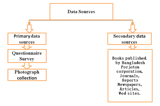
Fig : Sources of data collection
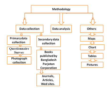
Fig : Methodology
STUDY AREA
The Chittagong Hill Tracts (CHT) is a distinct region in terms of its ethnic, cultural and environmental diversity to the rest of Bangladesh. The Chittagong Hill Tracts, combining three hilly districts of Bangladesh Rrangamati, khagrachhari and Bandarban districts. The area of the Chittagong Hill Tracts is about 13,295 sq km, which is approximately one-tenth of the total area of Bangladesh.
Location
Chittagong Hill Tracts (CHT) the only extensive hilly area in Bangladesh lies in southeastern part of the country (21o 25’ N to 23o 45’ N latitude and 91o 54’ E to 92o 50’ E longitude) bordering Myanmar on the southeast, the Indian state of Tripura on the north, Mizoram on the east and Chittagong district on the west.
History of Chittagong hill tracts
This region was recorded in the first known map of Bengal, dated about 1550. However, long before in the year 953 a king of Arakan occupied the present districts of Chittagong Hill Tracts and Chittagong. Later in 1240, King of Tripura occupied this region. The Arakanese King recaptured the district in 1575 and continued possession till 1666. In fact this region frequently changed hands between the rulers of Hill Tripura and Arakan. The Mughals controlled the area from 1666 to 1760. In 1760 the area was ceded to east india company. The British occupied the Chittagong Hill Tracts in 1860 and made it a part of British India. They named it ‘Chittagong Hill Tracts’ (Parvatya Chattagram). The British saw the Hill Tracts as an extension of the Chittagong district. The hills to the south became the ‘Arakan Hill Tracts’ and those to the north ‘Hill Tippera’. Administratively, they brought the Chittagong Hill Tracts under the Province of Bengal. The Chittagong Hill Tracts Regulation of 1900, instituted a local system of tax collection with the headmen and chiefs at the apex. With the establishment of Pakistan in 1947, the Chittagong Hill Tracts came under the jurisdiction of Pakistan. After the independence of Bangladesh in 1971, it came under the jurisdiction of Bangladesh and entered into a period of remarkable changes and development. During the early eighties as part of the countrywide administrative reforms the Chittagong Hill Tracts was divided into three individual districts.
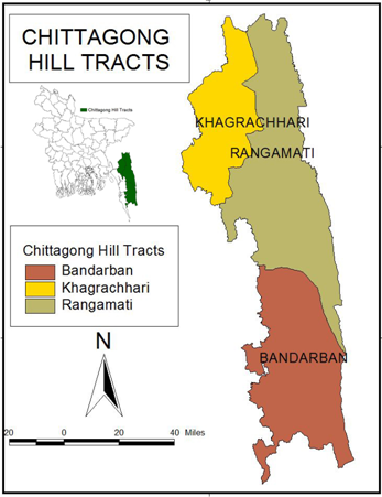
Map 01: Study Area – Chittagong hill tracts
Source: Arc View 3.3
Physical setting:
Physiographic
According to the physiographic of Bangladesh the CHT falls under the Northern and Eastern Hill unit and the High Hill or Mountain Ranges sub-unit. This sub-unit covers most of CHT, some small parts of southern Habiganj and the south and eastern borders of Maulvi Bazar. At present, all the mountain ranges of the Chittagong Hill Tracts are almost hogback ridges. They rise steeply, thus looking far more impressive than their height would imply. Most of the ranges have scarps in the west, with cliffs and waterfalls.
The region is characterised by a huge network of trellis and dendritic drainage consisting of some major rivers draining into the bay of bengal. The major rivers are karnafuli, sangu, matamuhuri and feni. Within the hill tracts, the Karnafuli has several important tributaries, of which Chengi, kasalong and Rainkhiang are the main ones.
Generally the hill ranges and the river valleys are longitudinally aligned. Four ranges, with an average elevation of over three hundred metres, strike in a north-south direction in the northern part of the hill tract districts. These are Phoromain range (Phoromain, 463m), Dolajeri range (Langtrai, 429m), Bhuachhari (Changpai, 611m) and Barkal range (Thangnang, 735m). South of the Karnafuli river within the Chittagong Hill Tracts, there are seven main mountain ranges within Bangladesh. These are: Muranja range (Basitaung, 664m), Wayla range (most of this range is in Myanmar), Chimbook range (Tindu, 898m), Batimain range (Batitaung, 526m), Politai range (Keokradang, 884m; Ramiu Taung 921m, Saichal-Mowdok range (Bilaisari, 669m) and Saichal range. Saichal range contains the highest peaks of Bangladesh. These are Waibung (808m), Rang Tlang (958m), Mowdok Tlang (905m), and Mowdok Mual (1,003m) which is on the border with Myanmar.
Some of these hill ranges also contain important geological structures to form excellent structural traps for natural gas accumulation. The structures are: Semutang anticline (average elevation is 80m except in some areas where it reaches over 160m), Sitapahar anticline (245 to 330m in the south to middle of the structure and 330 to 410m in the northern part), Matamuhuri anticline (average elevation ranges from 245 to 330m in the northern part, but in the southern part it increases from 410 to 570m and the maximum elevation is 710m in the south) and Bandarban anticline (maximum elevation varies between 650 and 800m, with three peaks of around 935m, 960m and 965m located from north to south).
Climate
The weather of this region is characterised by tropical monsoon climate with mean annual rainfall nearly 2540 mm in the north and east and 2540 mm to 3810 mm in the south and west. The dry and cool season is from November to March; pre-monsoon season is April-May which is very hot and sunny and the monsoon season is from June to October, which is warm, cloudy and wet.
Soil conditions
The hill soils (dystric cambisols) are mainly yellowish brown to reddish brown loams which grade into broken shale or sandstone as well as mottled sand at a variable depth. The soils are very strongly acidic.
Vegetation
The hills are unsuitable for cultivation but natural vegetation remains widely. jhum cultivation is being practiced on the hill slopes. Cotton, rice, tea and oilseeds are raised in the valleys between the hills.
Cultural setting:
Population
Dominated by Mongolian group. The major Mongolian tribes are chakma, Tipra, murong and magh. In fact the Chittagong Hill Tracts host thirteen different tribes who are divided into nearly a hundred different sects. Total population enumerated in the 1991 census was 1.042 million of which 562,597 were male and 479,776 female. buddhism is being followed by Chakma and Marma, the hinduism by the Tripura and christianity by Mizo and Bawm. Some other tribes maintain harmony amongst the spirit, animal and plant.
Table 01: Population of the CHT region
| Tribal group | Main religion | 1956 | 1981 |
| Chakma | Buddhism | 140,000 | 230,000 |
| Taungchengya | Buddhism | 15,000 | 20,000 |
| Marma | Buddhism | 80,000 | 120,000 |
| Sak | Buddhism | 2,000 | 1,500 |
| Khyeng | Community religion | 1,000 | 1,500 |
| Tripura | Hinduism | 30,000 | 40,000 |
| Riang/Brong | Hinduism | 7,000 | 10,000 |
| Mru | Community Religion | 17,000 | 20,000 |
| Khumi | Community Religion | 2,500 | 1,000 |
| Bawm | Christianity | 3,500 | 8,000 |
| Pangkhua | Christianity | 1,500 | 2,000 |
| Lushai/Mizo | Christianity | 500 | 1,000 |
| Tribal total | 300,000 | 455,000 | |
| Bangali | Islam | 30,000 | 290,000 |
| CHT Total | 330,000 | 745,000 |
Source: Banglapedia
The pattern of human settlement throughout the CHT showed much territorial intermingling. Some groups dominated in certain parts of the CHT (eg the Chakma in the centre, and Marma in the tract between the Karnafuli and Sangu rivers) and others were concentrated in specific areas (eg Tripura in the north, Mru in the south). There was also a distinction between groups living in hill valleys and groups living on the ridges of the hills. Nevertheless, in many places local settlement patterns were highly complex. For example, seven different groups could be found living in close proximity in an area of about 15 by 10 km around the township of Ruma on the Sangu river in the southern CHT.
Communication
Highways and waterways are the chief means of communication. The length of the metal led roads within Rangamati, Khagrachhari and Bandarban districts is 123 km, 134 km and 296 km respectively. Similarly, the length of the waterways in the above districts is 444 km, 640 km and 166 km respectively.
Economy
Semutang gas field located in Khagrachhari district is the only gas field in Chittagong Hill Tracts. It was discovered in 1969 by the national oil company (Oil and Gas Development Corporation of the then Pakistan). However, gas seeps are reported from Sitapahar (Kaptai) and Jaldi wells, while oil seep from Uttan Chatra. Other resources include sandstones, boulders (calcareous concretions), conglomerates and lignitic coals. A paper mill is built on the bank of the karnafuli at Chandraghona and a hydro power station (karnafuli hydro power station) at Kaptai with the aim of generating electricity and providing irrigation and flood control facilities. Hill people produce woven cotton goods and bamboo nets and baskets.
Others
Lakes
There are two natural lakes (Rainkhiangkine lake and bagakine lake) and one artificial lake (kaptai lake). The Kaptai lake covers an area of about 767 sq km in dry season and about 1,036 sq km in the monsoon.
Flora
The hills, rivers and cliffs are covered with dense bamboo breaks, tall trees and creeper jungles. The valleys are covered with thick forest. The vegetation is characterised by semi-evergreen (deciduous) to tropical evergreen dominated by tall trees belonging to dipterocarpaceae, euphorbiaceae, lauraceae, leguminacae and rubiaceae.
Fauna
The fauna mainly includes monkey, fox, jungle cat, fishing cat, wild boar, land turtle, king cobra, reticulated python, rat snake and other non-poisonous snakes together with large number of species of lizards and amphibians like frog and toad, and tree frogs. The bird life of the Chittagong Hill Tracts is wonderfully rich. More than 60 families of birds are found.
Forest
Most of the hills are covered with forests containing valuable timber trees, bamboos, canes and a kind of grass known as shan.
CONCLUSION
From the above discussion we can say that, research seeks to develop principles and generalization by analyzing the relationship between variables. Research outline is needed for any kind of research. Research methodology provides the methods systems and processes of data collection, the logic behind the selection of the study area and some hypothetical assumptions to facilate the study. Research design organization of research work, use published and unpublished materials and delimitation of recanting extra ordinary significance.

Some are parts:
Development of Eco Tourism in Chittagong Hill Tracts Problems and Prospects (Part 1)
Development of Eco Tourism in Chittagong Hill Tracts Problems and Prospects (Part 2)