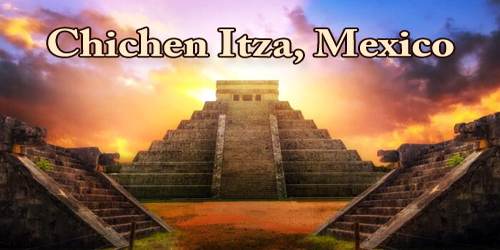
Chichén Itzá was a large pre-Columbian city built by the Maya people of the Terminal Classic period. The archaeological site is located in Tinúm Municipality, Yucatán State, Mexico. Although it’s an important tourist attraction, Chichen Itza also remains an active archeological site. New discoveries are still being unearthed in the area, providing even more insight into the culture and accomplishments of the Mayan people, who ruled much of present-day Mexico and Central America prior to the arrival of European colonists.
Chichen Itza was named a UNESCO World Heritage Site in 1988 and, in 2007, it was voted in a global survey as one of the New Seven Wonders.
Chichen Itza was a major focal point in the Northern Maya Lowlands from the Late Classic (c. AD 600-900) through the Terminal Classic (c. AD 800-900) and into the early portion of the Postclassic period (c. AD 900-1200). The site exhibits a multitude of architectural styles, reminiscent of styles seen in central Mexico and of the Puuc and Chenes styles of the Northern Maya lowlands. The presence of central Mexican styles was once thought to have been representative of direct migration or even conquest from central Mexico, but most contemporary interpretations view the presence of these non-Maya styles more as the result of cultural diffusion.
It is located some 90 miles (150 km) east-northeast of Uxmal and 75 miles (120 km) east-southeast of the modern city of Mérida. The only source of water in the arid region around the site is from wells (cenotes) formed by sinkholes in limestone formations. Two big cenotes on the site made it a suitable place for the city and gave it its name, from chi (“mouths”), chen (“wells”), and Itzá, the name of the Maya tribe that settled there.
The name Chichen Itza is a Mayan language term for “at the mouth of the well of the Itza.” The Itza were an ethnic group of Mayans who had risen to power in the northern part of the Yucatan peninsula, where the city is located. The well in the name refers to a number of underground rivers that run beneath the region and likely served as the source of water for the city. This easy access to water made the location perfect for a city the size of Chichen Itza.
Several archaeologists in the late 1980s suggested that unlike previous Maya polities of the Early Classic, Chichen Itza may not have been governed by an individual ruler or a single dynastic lineage. Instead, the city’s political organization could have been structured by a “multepal” system, which is characterized as rulership through council composed of members of elite ruling lineages.
This theory was popular in the 1990s, but in recent years, the research that supported the concept of the “multepal” system has been called into question, if not discredited. The current belief trend in Maya scholarship is toward the more traditional model of the Maya kingdoms of the Classic Period southern lowlands in Mexico.
Chichén was founded about the 6th century CE, presumably by Maya peoples of the Yucatán Peninsula who had occupied the region since the Pre-Classic, or Formative, Period (1500 BCE-300 CE). The principal early buildings are in an architectural style known as Puuc, which shows a number of divergences from the styles of the southern lowlands. These earliest structures are to the south of the Main Plaza and include the Akabtzib (“House of the Dark Writing”), the Chichanchob (“Red House”), the Iglesia (“Church”), the Casa de las Monjas (“Nunnery”), and the observatory El Caracol (“The Snail”). There is evidence that, in the 10th century, after the collapse of the Maya cities of the southern lowlands, Chichén was invaded by foreigners, probably Maya speakers who had been strongly influenced by and perhaps were under the direction of the Toltec of central Mexico. These invaders may have been the Itzá for whom the site is named; some authorities, however, believe the Itzá arrived 200 to 300 years later.
The layout of Chichen Itza site core developed during its earlier phase of occupation, between 750 and 900 AD. Its final layout was developed after 900 AD, and the 10th century saw the rise of the city as a regional capital controlling the area from central Yucatán to the north coast, with its power extending down the east and west coasts of the peninsula. The earliest hieroglyphic date discovered at Chichen Itza is equivalent to 832 AD, while the last known date was recorded in the Osario temple in 998.
By the ninth century, Chichen Itza was a de facto regional capital, with its rulers controlling much of the central and northern Yucatan peninsula.
Via its port at Isla Cerritos on the northern coast, Chichen Itza became an important commercial center, trading in goods including gold and other treasures with other cities throughout the Americas.
At its height, it is believed that as many as 50,000 people lived in the city. This population may have also been fairly diverse, at least by standards of the time, with residents immigrating to the city from beyond the Yucatan, including from present-day Central America.
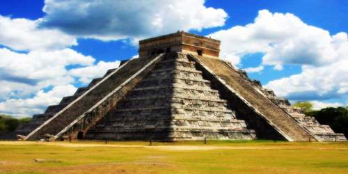
In any event, the invaders were responsible for the construction of such major buildings as El Castillo (“The Castle”), a pyramid that rises 79 feet (24 meters) above the Main Plaza. El Castillo has four sides, each with 91 stairs and facing a cardinal direction; including the step on the top platform, these combine for a total of 365 steps the number of days in the solar year. During the spring and autumnal equinoxes, shadows cast by the setting sun give the appearance of a snake undulating down the stairways. A carving of a plumed serpent at the top of the pyramid is symbolic of Quetzalcóatl (known to the Maya as Kukulcán), one of the major deities of the ancient Mesoamerican pantheon. Excavations within the nine-platform pyramid revealed another, earlier structure containing a red jaguar throne studded with jade.
Archaeologists have identified thirteen ballcourts for playing the Mesoamerican ballgame in Chichen Itza, but the Great Ball Court about 150 metres (490 ft) to the north-west of the Castillo is by far the most impressive. It is the largest and best preserved ball court in ancient Mesoamerica. It measures 168 by 70 metres (551 by 230 ft). The parallel platforms flanking the main playing area are each 95 metres (312 ft) long. The walls of these platforms stand 8 metres (26 ft) high; set high up in the centre of each of these walls are rings carved with intertwined feathered serpents.
Six sculpted reliefs run the length of the walls of the court, apparently depicting the victors of the game holding the severed head of a member of the losing team. On the upper platform at one end of the court stands the Temple of the Jaguars, inside of which is a mural showing warriors laying siege to a village. Standing on the platform of the temple to the north of the court, it is possible to hear a whisper from 150 feet (46 metres) away.
At the base of the high interior walls are slanted benches with sculpted panels of teams of ball players. In one panel, one of the players has been decapitated; the wound emits streams of blood in the form of wriggling snakes. At one end of the Great Ball Court is the North Temple, also known as the Temple of the Bearded Man (Templo del Hombre Barbado). This small masonry building has detailed bas relief carving on the inner walls, including a center figure that has carving under his chin that resembles facial hair. At the south end is another, much bigger temple, but in ruins.
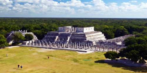
Other structures include the High Priest’s Grave and the Colonnade (Thousand Columns) and the adjoining Temple of the Warriors. Most of these buildings probably were completed in the Early Post-Classic Period (c. 900-1200). In the Late Post-Classic Period (c. 1200-1540), Chichén appears to have been eclipsed by the rise of the city of Mayapán. For a time Chichén Itzá joined Uxmal and Mayapán in a political confederacy known as the League of Mayapán.
Indeed, historians believe that many of the political and economic activities of the city had shifted to Mayapan, a newer community built to the south and west of Chichen Itza, by the mid-1200s. There is some evidence that Chichen Itza may have been raided and looted at this time, although that remains up for debate.
In 1526 Spanish Conquistador Francisco de Montejo (a veteran of the Grijalva and Cortés expeditions) successfully petitioned the King of Spain for a charter to conquer Yucatán. His first campaign in 1527, which covered much of the Yucatán Peninsula, decimated his forces but ended with the establishment of a small fort at Xaman Haʼ, south of what is today Cancún. Montejo returned to Yucatán in 1531 with reinforcements and established his main base at Campeche on the west coast. He sent his son, Francisco Montejo The Younger, in late 1532 to conquer the interior of the Yucatán Peninsula from the north. The objective from the beginning was to go to Chichén Itzá and establish a capital.
Long left to the jungle, Chichén Itzá remained sacred to the Maya. Excavation began in the 19th century, and the site became one of Mexico’s prime archaeological zones. A legendary tradition at Chichén was the Cult of the Cenote, involving human sacrifice to the rain god, in which victims were thrown into the city’s major cenote (at the northernmost part of the ruin), along with gold and jade ornaments and other valuables.
A number of important structures of the original city remain standing, some thanks to restoration efforts on the part of the Mexican government. Among them:
El Castillo: Also known as the Temple of Kukulkan, named for a Mayan deity that appears as a feathered serpent. This pyramid-shaped structure stands close to 100 feet high.
The Great Ball Court: Just to the northwest of El Castillo, this structure was used for sport—primarily a team game using a ball.
The North Temple: Also called the Temple of the Bearded Man, this small building is adjacent to the Great Ball Court and features a carving on its inner walls, with the central figure of a man with a carving under his chin that resembles facial hair.
The Steam Bath: This structure features a water bath and steam chamber operated by using heated stones.
Sacbe Number One: One of the paved streets of the city that extends nearly 900 feet.
Temple of the Warriors: Another large, stepped pyramid.
Group of a Thousand Columns: A series of exposed columns that are believed to have supported a large roof system.
El Mercado: A square structure at the southern end of the Temple of the Warriors that archeologists believe served as the city’s marketplace.
El Osario: Another step-pyramid structure with a temple at its peak.
Today, it is one of the most well restored Mayan sites in Mexico, offering an astounding glimpse into this culture. It is also one of Mexico’s biggest tourist attractions. The huge pyramid is the most recognizable symbol of Chichen Itza, but the site is very large, with many ruins to explore.
The ruins of Chichen Itza are federal property, and the site’s stewardship is maintained by Mexico’s Instituto Nacional de Antropología e Historia (National Institute of Anthropology and History). The land under the monuments had been privately owned until 29 March 2010, when it was purchased by the state of Yucatán. Chichen Itza is one of the most visited archaeological sites in Mexico with over 2.6 million tourists in 2017.
Information Sources: