Country
Formal Name: People’s Republic of Bangladesh
Short Form: Bangladesh
Term for Citizens: Bangladeshi(s)
Capital: Dhaka
Date of Independence: April 17, 1971; eastern part of Pakistan (East Pakistan), 1947-71.
Geography
Size: Total 144,000 square kilometers, land area 133,910 square kilometers.
Topography: Broad deltaic plain. Chittagong Hills in southeast, Low Hills in northeast and modest-elevation highlands in north and northwest.
Climate: Subtropical monsoon climate, wide seasonal variations in rainfall, moderately warm temperatures, high humidity. Climate generally uniform throughout entire country. Subject to severe natural disasters, such as floods, tropical cyclones, tornadoes, and tidal bores.
Economy
Gross National Product (GNP): US$15.6 billion in fiscal year (FY) 1986 at current prices; per capita GNP US$150; 4.5 percent real growth in FY 1987.
Agriculture: Large-scale subsistence farming, labor intensive, heavily dependent on monsoon rains. Main crops rice, jute, wheat, tea, and forestry products. Fisheries of increasing importance.
Industry: Jute manufactures, ready-made garments, cotton textiles, seafood processing, and pharmaceuticals.
Services: Substantial exported labor, primarily to Persian Gulf nations. As many as 450,000 Bangladeshis abroad in 1987; important source of foreign currency remittances.
Resources: Sufficient natural gas for country’s nitrogenous fertilizer needs. Abundant proven coal reserves. Offshore and onshore reserves of petroleum. Hydroelectric power and thermal power sources. Biofuels widely used in rural areas.
Exports: Approximately US$819 million in FY 1986. Raw jute and jute manufactures, frozen seafood, ready-made garments, tea, and leather goods. United States, Japan, and Britain largest buyers.
Imports: Approximately US$2.4 billion in FY 1986. Food grains, fuels, raw cotton, fertilizer, and manufactured products. Singapore, Japan, and United States largest suppliers.
Balance of Payments: Has had negative trade balance since independence in 1971. Exports represented 30 percent, imports 70 percent of total annual trade in FY 1986.
Exchange Rate: 34.20 takas=US$1 (September 1988).
Fiscal Year: July 1 to June 30.
Government and Politics
Government: Presidential form of government with popularly elected president and appointed prime minister. 1972 Constitution amended numerous times to reflect new political realities. Unicameral Parliament (known as Jatiyo Sangsad, or House of the People) with 300 members. Elections held in March 1988.
Politics:
Authoritarian or military regimes have run Bangladesh almost since its inception. Regime in power traditionally controls government and Parliament through single national political party: under Sheikh Mujibur Rahman (1972-75), the Awami League (People’s League); under Ziaur Rahman (1977-81), the Bangladesh Nationalist Party; and under Hussain Muhammad Ershad (since 1982), the Jatiyo Party (National Party). Numerous opposition parties joined periodically in fractious alliances against party in power. In 1988 most important were Awami League, centrist Bangladesh Nationalist Party, leftist Jatiyo Samajtantrik Dal (National Socialist Party), and conservative, pro-Islamic Jamaat e Islami (Congregation of Islam). Student and workers’ wings of these and other parties important players in national politics.
Justice: Supreme Court headed by chief justice. Two Supreme Court divisions: High Court Division with seven regional benches, and Appellate Division in Dhaka. Grass-roots judicial system at village level. British-style criminal codes, amended in Pakistan and Bangladesh eras.
Administrative Divisions: Divided into four administration divisions headed by commissioners. Divisions divided into twenty-one regions, further subdivided into sixty-four districts (zilas). Urban subdivisions in 1988 included four municipal corporations (Dhaka, Chittagong, Rajshahi, and Khulna–which corresponded to the four divisions in name), eightyseven municipalities (pourashavas), and thirty townships (thanas). Rural subdivisions included 460 subdistricts (upazilas) and 4,401 unions. Popularly elected representative councils (parishads) at various administrative levels except divisions and regions.
Foreign Affairs: Heavily dependent on massive infusions of foreign development aid, Bangladesh maintains neutral policy. Maintains friendly relations with United States, Soviet Union, and China; close relations with Muslim nations; and proper but watchful relations with neighboring India. Member of Afro-Asian People’s Solidarity Organization, Asian Development Bank, Colombo Plan, Commonwealth of Nations, Customs Cooperation Council, Group of 77, International Bank for Reconstruction and Development, International Olympic Committee, International Rice Council, International Telecommunications Satellite Organization, INTERPOL, Islamic Development Bank, Nonaligned Movement, Organization of the Islamic Conference, South Asian Association for Regional Cooperation, United Nations and all its affiliated agencies, World Federation of Trade Unions, and World Tourism Organization.
ISLAMIZATION OF BENGAL, 1202-1757
The Turkish conquest of the subcontinent was a long, drawn-out process covering several centuries. It began in Afghanistan with the military forays of Mahmud of Ghazni in 1001. By the early thirteenth century, Bengal fell to Turkish armies. The last major Hindu Sena ruler was expelled from his capital at Nadia in western Bengal in 1202, although lesser Sena rulers held sway for a short while after in eastern Bengal.
Bengal was loosely associated with the Delhi Sultanate, established in 1206, and paid a tribute in war elephants in order to maintain autonomy. In 1341 Bengal became independent from Delhi, and Dhaka was established as the seat of the governors of independent Bengal. Turks ruled Bengal for several decades before the conquest of Dhaka by forces of the Mughal emperor Akbar the Great (1556-1605) in 1576. Bengal remained a Mughal province until the beginning of the decline of the Mughal Empire in the eighteenth century.
Under the Mughals, the political integration of Bengal with the rest of the subcontinent began, but Bengal was never truly subjugated. It was always too remote from the center of government in Delhi. Because lines of communications were poor, local governors found it easy to ignore imperial directives and maintain their independence. Although Bengal remained provincial, it was not isolated intellectually, and Bengali religious leaders from the fifteenth century onward have been influential throughout the subcontinent.
The Mughals in their heyday had a profound and lasting effect on Bengal. When Akbar ascended the throne at Delhi, a road connecting Bengal with Delhi was under construction and a postal service was being planned as a step toward drawing Bengal into the operations of the empire. Akbar implemented the present-day Bengali calendar (see Glossary), and his son, Jahangir (1605-27), introduced civil and military officials from outside Bengal who received rights to collect taxes on land. The development of the zamindar (tax collector and later landlord–see Glossary) class and its later interaction with the British would have immense economic and social implications for twentieth-century Bengal. Bengal was treated as the “breadbasket of India” and, as the richest province in the empire, was drained of its resources to maintain the Mughal army. The Mughals, however, did not expend much energy protecting the countryside or the capital from Arakanese or Portuguese pirates; in one year as many as 40,000 Bengalis were seized by pirates to be sold as slaves, and still the central government did not intervene. Local resistance to imperial control forced the emperor to appoint powerful generals as provincial governors. Yet, despite the insecurity of the Mughal regime, Bengal prospered. Agriculture expanded, trade was encouraged, and Dhaka became one of the centers of the textile trade in South Asia.
In 1704 the provincial capital of Bengal was moved from Dhaka to Murshidabad. Although they continued to pay tribute to the Mughal court, the governors became practically independent rulers after the death in 1707 of Aurangzeb, the last great Mughal emperor. The governors were strong enough to fend off marauding Hindu Marathas from the Bombay area during the eighteenth century. When the Mughal governor Alivardi died in 1756, he left the rule of Bengal to his grandson Siraj ud Daulah, who would lose Bengal to the British the following year.
The War for Bangladeshi Independence, 1971
On March 25, the Pakistan Army launched a terror campaign calculated to intimidate the Bengalis into submission. Within hours a wholesale slaughter had commenced in Dhaka, with the heaviest attacks concentrated on the University of Dhaka and the Hindu area of the old town. Bangladeshis remember the date as a day of infamy and liberation. The Pakistan Army came with hit lists and systematically killed several hundred Bengalis. Mujib was captured and flown to West Pakistan for incarceration.
To conceal what they were doing, the Pakistan Army corralled the corps of foreign journalists at the International Hotel in Dhaka, seized their notes, and expelled them the next day. One reporter who escaped the censor net estimated that three battalions of troops–one armored, one artillery, and one infantry–had attacked the virtually defenseless city. Various informants, including missionaries and foreign journalists who clandestinely returned to East Pakistan during the war, estimated that by March 28 the loss of life reached 15,000. By the end of summer as many as 300,000 people were thought to have lost their lives. Anthony Mascarenhas in Bangladesh: A Legacy of Blood estimates that during the entire nine-month liberation struggle more than 1 million Bengalis may have died at the hands of the Pakistan Army.
The West Pakistani press waged a vigorous but ultimately futile campaign to counteract newspaper and radio accounts of wholesale atrocities. One paper, the Morning News, even editorialized that the armed forces were saving East Pakistanis from eventual Hindu enslavement. The civil war was played down by the government-controlled press as a minor insurrection quickly being brought under control.
After the tragic events of March, India became vocal in its condemnation of Pakistan. An immense flood of East Pakistani refugees, between 8 and 10 million according to various estimates, fled across the border into the Indian state of West Bengal. In April an Indian parliamentary resolution demanded that Prime Minister Indira Gandhi supply aid to the rebels in East Pakistan. She complied but declined to recognize the provisional government of independent Bangladesh.
A propaganda war between Pakistan and India ensued in which Yahya threatened war against India if that country made an attempt to seize any part of Pakistan. Yahya also asserted that Pakistan could count on its American and Chinese friends. At the same time, Pakistan tried to ease the situation in the East Wing. Belatedly, it replaced Tikka, whose military tactics had caused such havoc and human loss of life, with the more restrained Lieutenant General A.A.K. Niazi. A moderate Bengali, Abdul Malik, was installed as the civilian governor of East Pakistan. These belated gestures of appeasement did not yield results or change world opinion.
On December 4, 1971, the Indian Army, far superior in numbers and equipment to that of Pakistan, executed a 3-pronged pincer movement on Dhaka launched from the Indian states of West Bengal, Assam, and Tripura, taking only 12 days to defeat the 90,000 Pakistani defenders. The Pakistan Army was weakened by having to operate so far away from its source of supply. The Indian Army, on the other hand, was aided by East Pakistan’s Mukti Bahini (Liberation Force), the freedom fighters who managed to keep the Pakistan Army at bay in many areas (see The Liberation War , ch. 5).
GEOGRAPHY
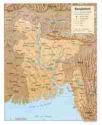
The Land
The physiography of Bangladesh is characterized by two distinctive features: a broad deltaic plain subject to frequent flooding, and a small hilly region crossed by swiftly flowing rivers. The country has an area of 144,000 square kilometers and extends 820 kilometers north to south and 600 kilometers east to west. Bangladesh is bordered on the west, north, and east by a 2,400-kilometer land frontier with India and, in the southeast, by a short land and water frontier (193 kilometers) with Burma. On the south is a highly irregular deltaic coastline of about 600 kilometers, fissured by many rivers and streams flowing into the Bay of Bengal. The territorial waters of Bangladesh extend 12 nautical miles, and the exclusive economic zone of the country is 200 nautical miles.
Roughly 80 percent of the landmass is made up of fertile alluvial lowland called the Bangladesh Plain. The plain is part of the larger Plain of Bengal, which is sometimes called the Lower Gangetic Plain. Although altitudes up to 105 meters above sea level occur in the northern part of the plain, most elevations are less than 10 meters above sea level; elevations decrease in the coastal south, where the terrain is generally at sea level. With such low elevations and numerous rivers, water–and concomitant flooding–is a predominant physical feature. About 10,000 square kilometers of the total area of Bangladesh is covered with water, and larger areas are routinely flooded during the monsoon season (see Climate; River Systems , this ch.).
The only exceptions to Bangladesh’s low elevations are the Chittagong Hills in the southeast, the Low Hills of Sylhet in the northeast, and highlands in the north and northwest (see fig. 5). The Chittagong Hills constitute the only significant hill system in the country and, in effect, are the western fringe of the northsouth mountain ranges of Burma and eastern India. The Chittagong Hills rise steeply to narrow ridge lines, generally no wider than 36 meters, 600 to 900 meters above sea level. At 1,046 meters, the highest elevation in Bangladesh is found at Keokradong, in the southeastern part of the hills. Fertile valleys lie between the hill lines, which generally run north-south. West of the Chittagong Hills is a broad plain, cut by rivers draining into the Bay of Bengal, that rises to a final chain of low coastal hills, mostly below 200 meters, that attain a maximum elevation of 350 meters. West of these hills is a narrow, wet coastal plain located between the cities of Chittagong in the north and Cox’s Bazar in the south.
About 67 percent of Bangladesh’s nonurban land is arable. Permanent crops cover only 2 percent, meadows and pastures cover 4 percent, and forests and woodland cover about 16 percent. The country produces large quantities of quality timber, bamboo, and sugarcane. Bamboo grows in almost all areas, but high-quality timber grows mostly in the highland valleys. Rubber planting in the hilly regions of the country was undertaken in the 1980s, and rubber extraction had started by the end of the decade. A variety of wild animals are found in the forest areas, such as in the Sundarbans on the southwest coast, which is the home of the worldfamous Royal Bengal Tiger. The alluvial soils in the Bangladesh Plain are generally fertile and are enriched with heavy silt deposits carried downstream during the rainy season.
Climate
Bangladesh has a subtropical monsoon climate characterized by wide seasonal variations in rainfall, moderately warm temperatures, and high humidity. Regional climatic differences in this flat country are minor. Three seasons are generally recognized: a hot, humid summer from March to June; a cool, rainy monsoon season from June to October; and a cool, dry winter from October to March. In general, maximum summer temperatures range between 32°C and 38°C. April is the warmest month in most parts of the country. January is the coldest month, when the average temperature for most of the country is 10°C.
Winds are mostly from the north and northwest in the winter, blowing gently at one to three kilometers per hour in northern and central areas and three to six kilometers per hour near the coast. From March to May, violent thunderstorms, called northwesters by local English speakers, produce winds of up to sixty kilometers per hour. During the intense storms of the early summer and late monsoon season, southerly winds of more than 160 kilometers per hour cause waves to crest as high as 6 meters in the Bay of Bengal, which brings disastrous flooding to coastal areas.
Heavy rainfall is characteristic of Bangladesh. With the exception of the relatively dry western region of Rajshahi, where the annual rainfall is about 160 centimeters, most parts of the country receive at least 200 centimeters of rainfall per year (see fig. 1). Because of its location just south of the foothills of the Himalayas, where monsoon winds turn west and northwest, the region of Sylhet in northeastern Bangladesh receives the greatest average precipitation. From 1977 to 1986, annual rainfall in that region ranged between 328 and 478 centimeters per year. Average daily humidity ranged from March lows of between 45 and 71 percent to July highs of between 84 and 92 percent, based on readings taken at selected stations nationwide in 1986 (see fig. 3; table 2, Appendix).
About 80 percent of Bangladesh’s rain falls during the monsoon season. The monsoons result from the contrasts between low and high air pressure areas that result from differential heating of land and water. During the hot months of April and May hot air rises over the Indian subcontinent, creating low-pressure areas into which rush cooler, moisture-bearing winds from the Indian Ocean. This is the southwest monsoon, commencing in June and usually lasting through September. Dividing against the Indian landmass, the monsoon flows in two branches, one of which strikes western India. The other travels up the Bay of Bengal and over eastern India and Bangladesh, crossing the plain to the north and northeast before being turned to the west and northwest by the foothills of the Himalayas (see fig. 4).
Natural calamities, such as floods, tropical cyclones, tornadoes, and tidal bores–destructive waves or floods caused by flood tides rushing up estuaries–ravage the country, particularly the coastal belt, almost every year. Between 1947 and 1988, thirteen severe cyclones hit Bangladesh, causing enormous loss of life and property. In May 1985, for example, a severe cyclonic storm packing 154 kilometer-per-hour winds and waves 4 meters high swept into southeastern and southern Bangladesh, killing more than 11,000 persons, damaging more than 94,000 houses, killing some 135,000 head of livestock, and damaging nearly 400 kilometers of critically needed embankments. Annual monsoon flooding results in the loss of human life, damage to property and communication systems, and a shortage of drinking water, which leads to the spread of disease. For example, in 1988 two-thirds of Bangladesh’s sixty-four districts experienced extensive flood damage in the wake of unusually heavy rains that flooded the river systems. Millions were left homeless and without potable water. Half of Dhaka, including the runways at the ZiaInternationalAirport–an important transit point for disaster relief supplies–was flooded. About 2 million tons of crops were reported destroyed, and relief work was rendered even more challenging than usual because the flood made transportation of any kind exceedingly difficult.
There are no precautions against cyclones and tidal bores except giving advance warning and providing safe public buildings where people may take shelter. Adequate infrastructure and air transport facilities that would ease the sufferings of the affected people had not been established by the late 1980s. Efforts by the government under the Third Five-Year Plan (1985-90) were directed toward accurate and timely forecast capability through agrometeorology, marine meteorology, oceanography, hydrometeorology, and seismology. Necessary expert services, equipment, and training facilities were expected to be developed under the United Nations Development Programme (see Foreign Assistance , ch. 3).
River Systems
The rivers of Bangladesh mark both the physiography of the nation and the life of the people. About 700 in number, these rivers generally flow south. The larger rivers serve as the main source of water for cultivation and as the principal arteries of commercial transportation. Rivers also provide fish, an important source of protein. Flooding of the rivers during the monsoon season causes enormous hardship and hinders development, but fresh deposits of rich silt replenish the fertile but overworked soil. The rivers also drain excess monsoon rainfall into the Bay of Bengal. Thus, the great river system is at the same time the country’s principal resource and its greatest hazard.
The profusion of rivers can be divided into five major networks (see fig. 5). The Jamuna-Brahmaputra is 292 kilometers long and extends from northern Bangladesh to its confluence with the Padma. Originating as the Yarlung Zangbo Jiang in China’s Xizang Autonomous Region (Tibet) and flowing through India’s state of Arunachal Pradesh, where it becomes known as the Brahmaputra (“Son of Brahma”), it receives waters from five major tributaries that total some 740 kilometers in length. At the point where the Brahmaputra meets the TistaRiver in Bangladesh, it becomes known as the Jamuna. The Jamuna is notorious for its shifting subchannels and for the formation of fertile silt islands (chars). No permanent settlements can exist along its banks.
The second system is the Padma-Ganges, which is divided into two sections: a 258-kilometer segment, the Ganges, which extends from the western border with India to its confluence with the Jamuna some 72 kilometers west of Dhaka, and a 126-kilometer segment, the Padma, which runs from the Ganges-Jamuna confluence to where it joins the MeghnaRiver at Chandpur. The Padma-Ganges is the central part of a deltaic river system with hundreds of rivers and streams–some 2,100 kilometers in length–flowing generally east or west into the Padma.
The third network is the Surma-Meghna system, which courses from the northeastern border with India to Chandpur, where it joins the Padma. The Surma-Meghna, at 669 kilometers by itself the longest river in Bangladesh, is formed by the union of six lesser rivers. Below the city of Kalipur it is known as the Meghna. When the Padma and Meghna join together, they form the fourth river system–the Padma-Meghna–which flows 145 kilometers to the Bay of Bengal.
This mighty network of four river systems flowing through the Bangladesh Plain drains an area of some 1.5 million square kilometers. The numerous channels of the Padma-Meghna, its distributaries, and smaller parallel rivers that flow into the Bay of Bengal are referred to as the Mouths of the Ganges. Like the Jamuna, the Padma-Meghna and other estuaries on the Bay of Bengal are also known for their many chars.
A fifth river system, unconnected to the other four, is the Karnaphuli. Flowing through the region of Chittagong and the Chittagong Hills, it cuts across the hills and runs rapidly downhill to the west and southwest and then to the sea. The Feni, Karnaphuli, Sangu, and Matamuhari–an aggregate of some 420 kilometers–are the main rivers in the region. The port of Chittagong is situated on the banks of the Karnaphuli. The Karnaphuli Reservoir and Karnaphuli Dam are located in this area. The dam impounds the KarnaphuliRiver’s waters in the reservoir for the generation of hydroelectric power (see Technological Advances , ch. 3).
During the annual monsoon period, the rivers of Bangladesh flow at about 140,000 cubic meters per second, but during the dry period they diminish to 7,000 cubic meters per second. Because water is so vital to agriculture, more than 60 percent of the net arable land, some 9.1 million hectares, is cultivated in the rainy season despite the possibility of severe flooding, and nearly 40 percent of the land is cultivated during the dry winter months. Water resources development has responded to this “dual water regime” by providing flood protection, drainage to prevent overflooding and waterlogging, and irrigation facilities for the expansion of winter cultivation. Major water control projects have been developed by the national government to provide irrigation, flood control, drainage facilities, aids to river navigation and road construction, and hydroelectric power. In addition, thousands of tube wells and electric pumps are used for local irrigation. Despite severe resource constraints, the government of Bangladesh has made it a policy to try to bring additional areas under irrigation without salinity intrusion (see Agriculture , ch. 3).
Water resources management, including gravity flow irrigation, flood control, and drainage, were largely the responsibility of the Bangladesh Water Development Board. Other public sector institutions, such as the Bangladesh Krishi Bank, the Bangladesh Rural Development Board, the Bangladesh Bank, and the Bangladesh Agricultural Development Corporation were also responsible for promotion and development of minor irrigation works in the private sector through government credit mechanisms (see Money and Banking , ch. 3).
Population Structure and Settlement Patterns
In the 1980s, Bangladesh faced no greater problem than population growth. Census data compiled in 1901 indicated a total of 29 million in East Bengal (see Glossary), the region that became East Pakistan and eventually Bangladesh. By 1951, four years after partition from India, East Pakistan had 44 million people, a number that grew rapidly up to the first postindependence census, taken in 1974, which reported the national population at 71 million. The 1981 census reported a population of 87 million and a 2.3 percent annual growth rate (see Population Control , this ch.). Thus, in just 80 years, the population had tripled. In July 1988 the population, by then the eighth largest in the world, stood at 109,963,551, and the average annual growth rate was 2.6 percent. According to official estimates, Bangladesh was expected to reach a population of more than 140 million by the year 2000.
Bangladesh’s population density provided further evidence of the problems the nation faced. In 1901 an average of 216 persons inhabited one square kilometer. By 1951 that number had increased to 312 per square kilometer and, in 1988, reached 821. By the year 2000, population density was projected to exceed 1,000 persons per square kilometer (see fig. 6; table 3; table 4, Appendix).
The crude birth rate per 1,000 population was 34.6 in 1981. This rate remained unchanged in 1985, following a 20-year trend of decline since 1961, when it had stood at 47 per 1,000. The rural birth rate was higher than birth rates in urban areas; in 1985 there were 36.3 births per 1,000 in the countryside versus 28 per 1,000 in urban areas. The crude death rate per 1,000 population decreased from 40.7 in 1951 to 12 per 1,000 in 1985; the urban crude death rate was 8.3, and the rural crude death rate was 12.9. The infant mortality rate per 1,000 live births was 111.9 in 1985, a distinct improvement from as recently as 1982, when the rate was 121.9. Life expectancy at birth was estimated at 55.1 years in 1986. Men and women have very similar life expectancies at 55.4 and 55, respectively. With an average life expectancy of 58.8 years, urban dwellers in 1986 were likely to live longer than their rural counterparts (average life expectancy 54.8 years). The sex ratio of the population in 1981 was 106 males to 100 females (see fig. 7; table 5, Appendix).
In the late 1980s, about 82 percent of the population of Bangladesh (a total of 15.1 million households) resided in rural areas. With the exception of parts of Sylhet and Rangamati regions, where settlements occurred in nucleated or clustered patterns, the villages were scattered collections of homesteads surrounded by trees. Continuous strings of settlements along the roadside were also common in the southeastern part of the country.
Until the 1980s, Bangladesh was the most rural nation in South Asia. In 1931 only 27 out of every 1,000 persons were urban dwellers in what is now Bangladesh. In 1931 Bangladesh had fifty towns; by 1951 the country had eighty-nine towns, cities, and municipalities. During the 1980s, industrial development began to have a small effect on urbanization. The 1974 census had put the urban population of Bangladesh at 8.8 percent of the total; by 1988 that proportion had reached 18 percent and was projected to rise to 30 percent by the year 2000.
In 1981 only two cities, Dhaka and Chittagong, had more than 1 million residents. Seven other cities–Narayanganj, Khulna, Barisal, Saidpur, Rajshahi, Mymensingh, and Comilla–each had more than 100,000 people. Of all the expanding cities, Dhaka, the national capital and the principal seat of culture, had made the most gains in population, growing from 335,928 in 1951 to 3.4 million in 1981. In the same period, Chittagong had grown from 289,981 to 1.4 million. A majority of the other urban areas each had between 20,000 and 50,000 people. These relatively small towns had grown up in most cases as administrative centers and geographically suitable localities for inland transportation and commercial facilities. There was no particular concentration of towns in any part of the country. In fact, the only large cities close to each other were Dhaka and Narayanganj.
Structure of Agricultural Production
Despite progress toward greater industrialization, in the late 1980s agriculture still accounted for nearly 50 percent of the value of Bangladesh’s GDP. Approximately 82 percent of the country’s population lived in rural areas, virtually all of them making their living exclusively or substantially from agriculture (see Rural Society , ch. 2). Domestic production increased at a relatively steady rate in the years following independence, but not fast enough to close the gap created by the continued rapid growth in population. According to official statistics, the real value of all crops and of agricultural production rose every year in the 1980s, but except for a 6.1-percent surge in FY 1981, the gains did not exceed 3.8 percent, and in 3 of the years it was less than 1 percent. The goal of food self-sufficiency by 1990 was asserted as part of the Third Five-Year Plan, but it could be achieved only under optimal conditions. Bangladesh was still importing an average of 2 million tons of food grains each year to meet minimum needs for the subsistence of the population. Most of the imports were on a grant or concessional basis from the United States, the World Food Programme, or other food aid donors (see Foreign Assistance , this ch.).
The agricultural year begins in late February, when the weather is dry and getting warmer. Over a period of several weeks each field is plowed three or four times; using a wooden plow and two oxen, one man can plow 0.02 hectares in an eight-to ten-hour workday. In addition to plowing, field preparation for irrigation involves construction and maintenance of plot boundaries half a meter high, using earth and weeds from the field. These boundaries also serve to retain water in the plots when the rains come a few months later. Traditional methods of irrigation include pitcher, swing basket, and a hollowed-out log fixed on a pivot and fitted with a counterbalance. These methods have a natural grace and beauty and are still practiced in rural areas throughout Bangladesh. They offer the dual advantages of depending entirely on locally available materials and on human power for their operation. In those rural areas where electricity is available, tube wells with electric pumps are becoming an important irrigation device.
Absolute production has increased, and there has been an impressive diversification into a wide variety of seeds and new crops, such as wheat and vegetables. In fact, the patterns of agriculture have been virtually transformed. A previously self-contained and self-reliant subsistence economy has given way to one dependent on inputs, credit, markets, and administrative support from outside. But the price has been high–literally–and in the late 1980s was getting higher. Abu Muhammad Shajaat Ali, in his study of the agricultural village of Shyampur, describes the local economy as a “near-saturated agroecosystem.” Continued population pressure has led in many areas to increases in output- per-unit area, but at very high rates of diminishing returns to inputs.
Shyampur exemplified the transformation going on in parts of the rural countryside affected by a modern market economy. The income of farmers in Shyampur, because of its proximity to Dhaka’s high-demand urban markets, was greater than in more typical villages of Bangladesh. According to Ali, 31 percent of Shyampur’s families in 1980 had a farm income greater than US$278 (Tk7,500) per year; 40 percent earned between US$93 and US$278; and the remaining 29 percent earned less than US$93. Eighty-four percent of farmers were also engaged for at least 100 days per year in off- farm work in small businesses or industrial occupations, with 70 percent of them earning between US$75 and US$295 and 23 percent receiving more than that. Virtually all of this employment was for males. As of 1980, it was rare for village females to be employed outside the household. The work they did in raising poultry, cultivating kitchen gardens, husking paddy, collecting fuel, and assisting neighboring families was not figured into calculations of income.
The ownership of agricultural land remained one of the most difficult problems in the Bangladesh countryside. During British rule, elite large landowners (zamindars–see Glossary), many of them absentee landowners, owned most of the land in East Bengal. After 1947 new laws abolished large estates and set limits on the amount of land one person could own. Many big Hindu landlords moved to India, but the wealthy Muslims who bought up their holdings became a new landlord elite. Legal ceilings on landownership resulted in little extra land for distribution to the poor because landlords arranged ways to vest ownership in the names of relatives. As a result, in most villages a few families controlled enough land to live comfortably and market a surplus for cash, while a large percentage of families had either no land or not enough to support themselves. Studies have suggested that in the mid-1980s the richest 10 percent of the village population controlled between 25 and 50 percent of the land, while the bottom 60 percent of the population controlled less than 25 percent. The disparities between the richest and poorest villagers appeared to be widening over time. The large number of landless or nearly landless peasants reduced the average landholding to only less than one hectare, down more than a third since 1971. Because Islamic inheritance law as practiced in Bangladesh calls for equal division of assets among all the sons, the large population increases led to increased fragmentation of landholdings and further impoverishment. Inheritance, purchase, and sale left the land of many families subdivided into a number of separate plots located in different areas of the village.
The ready availability of large numbers of poor laborers and the fragmented character of many landholdings has perpetuated a labor- intensive style of agriculture and unequal tenancy relations. At least a third of the households in most villages rent land. The renting households range from those without any land of their own to those middle-level peasants who try to supplement the produce grown on their own land with income from produce grown on additional land. Sharecropping is the most common form of tenancy agreement. Traditional sharecropping arrangements heavily favored the landlord over the sharecropper, with a fifty-fifty split of the produce and the tenant providing all inputs of labor and fertilizer. After decades of rural agitation, the 1984 Land Reforms Ordinance finally established the rule of three shares–one-third of the produce for the owner, one-third for the sharecropper, and one-third split according to the costs of cultivation. Poor peasants who could not obtain land as tenants had to work as agricultural laborers or find nonagricultural jobs. The 1984 Agricultural Labour Ordinance set the minimum daily wage for agricultural labor at 3.28 kilograms of rice or its cash equivalent. Employers who broke this rule could be brought to village courts and forced to pay compensation twice the amount of back wages. However, because village courts were dominated by landowners, there was still little official redress for the grievances of agricultural laborers. In fact, the structure of rural land control kept a great deal of power in the hands of relatively small groups of landlords (see Local Elites , ch. 4).
The Comilla Model, which began in 1959, has been the most successful and influential example of cooperative agricultural development in Bangladesh. Projects in Comilla District provided more modern technologies to farmers: low-lift water pumps; low-cost hand-dug six-inch tube wells; pilot research on adapting thirty- five-horsepower tractors for rice cultivation; new crop and animal varieties; testing and introduction of such inputs as chemical fertilizers, pesticides, and high-yield varieties of seeds; and new storage and processing technology. These innovations attracted resources to local rural institutions, against the prevailing urban orientation of the leadership elite. They provided some counterweight to the trend of ambitious village people seeking to leave the countryside in favor of the cities or foreign countries. Comilla, which received substantial assistance from MichiganStateUniversity and the Ford Foundation, remains a widely admired accomplishment, and the Bangladesh Academy of Rural Development, which gave broad dissemination to published reports on Comilla’s progress, is world-renowned because of it.
Historical People of Bangladesh
Ziaur Rahman
Ziaur Rahman was born at Bogra in 1936. He joined the army in 1953 and was commissioned in 1955. Towards the end of 1969, he went to West Germany for training and later on, spent a few months with the British army. In October 1970, Major Ziaur Rahman was transferred to the newly raised Eighteen East Bengal Regiment at Chittagong. While serving in this regiment and following the crackdown on the un armed civilians, he led the revolt against the Pakistan army and on March 26 & 27, 1971, he made the historic announcement of independendence for the 75 million freedom-loving people of Bangladesh. During this time the “Shadheen Bangla Betar” (Independent Bangla Radio) related the various news of the nine month long war.
In 1971, he was promoted to the rank of Lt. Colonel. While in Roumari, he formed the 1st Brigade of the Bangladesh Army with the Jawans of 1st, 2nd and Eighth Bengal Regiments. It later came to be known as “Z” force. In 1972 he was appointed Deputy Chief of Staff of the army. He was rapidly promoted from one rank to another and was promoted to the rank of Major General in 1973.
In August, 1975 he assumed the responsibility of the Chief of Staff following the change over of the Government. On November 7, 1975, he became the Chief Martial Law Administrator. He attended the non-aligned summit conferance in Colombo in August 1976 and paid an official visit to China in January, 1977 and to Iran in March, 1977.
Major General Ziaur Rahman was sworn as The President of Bangladesh on April 21st, 1977. He attended the Commonwealth Heads of Government Conference in London and paid state visits to many countries including Arabia and China. He was sworn in as the First Elected President of Bangladesh on June 12, 1979. Immediately after the election he formed a political party, styled as Bangladesh Nationalist Party. He held general elections on the basis of universal adult franchise in February 1979, and won a landslide victory. Immediately after the general election, he withdrew emergency and Martial law from the country and set the process of restoring democratisation in motion.
In his personal life President Zia was a familyman. He was married to Begum Khaleda Zia, who later became the first woman Prime Minister of Bangladesh between 1991-1995 and is now the current prime minister.
The nation bade the late President a tearful and loving farewell on May 31, 1981. On this very day President Zia was assassinated by a abortive military mutiny in Chittagong.
Sheikh Mujibur Rahman
Some of the biographers of the Father of the Nation Bangabandhu Sheikh Mujibur Rahman have said that he was the most astonishing and much talked about leader in South East Asia. In an age of military coup d’etat he attained power through elections and mass upsurge; in an age of decline of democracy he firmly established democracy in one of the countries of Asia and in an age of “Strong Men” he spurned the opportunity of becoming a dictator and instead chose to become the elected Prime Minister. The way he turned a nonviolent non-cooperation movement of unarmed masses into an armed struggle that successfully brought into reality the liberation of a new nation and the creation of a new state in barely ten months will remain a wonder of history.
March 7, 1971 was a day of supreme test in his life. The leaders of the military junta of Pakistan were on that day eagerly waiting to trap him. A contingent of heavily armed Pakistani troops was poised near the Suhrawardy Uddyan to wait for an order to start massacre the people on the plea of suppressing a revolt that Bangabandhu was about to declare against Pakistan at the meeting he was going to address there.
In fact, the entire Bangladesh was then in a state of revolt. The sudden postponement of the scheduled session of the newly elected National Assembly and the reluctance of the military leaders to transfer power to the elected representatives of the people had driven the people to desperation and they were seeking the opportunity to break away from the Pakistani colonial rule. Nearly two million freedom-loving people who assembled at the Suhrawardy Uddyan that day had but one wish, only one demand : “Bangabandhu, declare independence; give us the command for the battle for national liberation.”
The Father of the Nation spoke in a calm and restrained language. It was more like a sacred hymn than a speech spellbinding two million people. His historic declaration in the meeting on that day was : “Our struggle this time is for freedom. Our struggle this time is for independence”. This was the declaration of independence for Bangladeshis, for their liberation struggle. But he did not give the Pakistani military rulers the opportunity to use their arms. He foiled their carefully laid scheme. In the same speech he took care to put forward four proposals for the solution of the problem in a constitutional way and kept the door open for negotiations.
He was taller than the average Bangalee, had the same dark complexion and spoke in a vibrant voice. But what special power gave him the magnetic qualities of drawing a mass of seventy-five million people to him? This question stirred the minds of many people at home and abroad. He was not educated abroad nor was he born with a silver spoon in his mouth. Yet he was as dear to the educated Bangladeshi compatriots as to the illiterate and half-educated masses. He inspired the intelligentsia and the working classes alike. He did not climb to leadership overnight. It has been a slow and steady process. He attained his enviable eminence the hard way. He began as an humble worker at the bottom rung. He arduously climbed to the position of a national leader and rose to the very pinnacle as the Father of the Nation.
He was born in a middle class Bangalee family and his political leadership arose out of the aims and aspirations of the ordinary Bangalee. He was inseparably linked with the hopes and aspirations, the joys and sorrows, the travails and triumphs of these ordinary people. He spoke their language. He gave voice to their hopes and aspirations. Year after year he spent the best days of his youth behind the prison bars. That is why his power was the power of the people.
Whoever has once come in contact with him has admitted that his personality, a mingling of gentle and stern qualities, had an uncanny magical attraction. He is as simple as a child yet unbending in courage; as strong as steel when necessary. Coupled with this was his incomparable strength of mind and steadfast devotion to his own ideals. He was a nationalist in character, a democrat in behavior, a socialist in belief and a secularist by conviction.
Bangabandbu had to move forward step by step in his struggle. He had to change the tactics and the slogans of the movement several times. It can thus be said that though the period of direct struggle for freedom was only nine months, the indirect period of this struggle spread over 25 years. This 25-year period can be divided into several stages. These are : (a) organizational stage of the democratic movement; (b) movement against BPC or Basic Principles Committee’s report; (c) language movement; (d) forging of electoral unity and the victory of the democratic United Front; (e) military rule; (f) movement against the military rule; (g) movement for autonomy; (h) the historic Six-Point movement; (i) electoral victory and the non-cooperation movement; and j) armed liberation struggle.
Bangabandhu has been closely associated with every phase of this 25-year long struggle for freedom and independence. Bangladesh and Bangabandhu have, therefore, become inseparable. We cannot speak of one without the other.
While still adolescent, he took his first political lesson from Hussain Shaheed Suhrawardy, a leading political personality of the then Bangladesh. It was in Faridpur that Young Suhrawardy and adolescent Sheikh Mujib came to know each other. Both of them were attracted to each other from that first acquaintance. Adolescent Mujib grew up under the gathering gloom of the storm-tossed politics of the sub-continent and the Second World War. He witnessed the ravages of war and the stark realities of the 1943 famine and the epidemics in which about five million people lost their lives. The miserable plight of the people under colonial rule turned him into a rebel.
He passed his matriculation examination in 1942. His studies had been interrupted for about four years due to an attack of beriberi. He got acquainted with the revolutionary activities of Netaji Subhash Chandra Bose during the HallwellMonument movement in Calcutta. Suhrawardy’s staunchly logical approach and Subhash Bose’s spirit of dedication influenced him immensely. He was influenced by another great leader, “Sher-e-Bangla” A.K. Fazlul Huq and his political philosophy of the plain fare (“dal-bhat”) for all. At that very early stage he realised that in a poor exploited country political programmes must be complimentary to economic programmes.
He completed his college education in Calcutta. His sojourn to the prisons began in his teens. He first spent six days in a prison for participating in a political movement. While he was a student in Calcutta, he moved the natural eddies of the political movements of the subcontinent and got himself associated with the Muslim League and the Pakistan movement. But soon after the creation of Pakistan and the partition of Bengal in 1947, he realised that his people had not attained real independence. What had happened was a change of masters. Bangladesh would have to make preparations for independence movement a second time.
He graduated in the same year and came to develop a deep acquaintance with the works of Bernard Shaw. Karl Marx and Rabindranath Tagore. The horizon of his thought process began to expand from that time. He realised that Bangladesh was a geographical unit and its geographical nationalism was separate; its economic, political and cultural characters were also completely different from those of the western part of Pakistan. Over and above, linguistic differences and a physical distance of about 1,500 miles between them made the two parts of Pakistan totally separate from each other.
He could, therefore, realize that by keeping the two areas under the forced bonds of one state structure in the name of religious nationalism, rigid political control and economic exploitation would be perpetrated on the eastern part. This would come as a matter of course because the central capital and the economic and military headquarters of Pakistan had all been set up in the western part.
The new realization and political thinking took roots in his mind as early as 1948. He was then a student in the Law faculty of DhakaUniversity. A movement was launched that very year on the demand to make Bengali one of the state languages of Pakistan. In fact, this movement can be termed as the first stirrings of the movement of an independent Bangladesh. This demand for cultural freedom gradually led to the demand for national independence. During that language movement, Bangabandhu was arrested on March 11, 1948. During the blood-drenched language movement of 1952 also he was pushed behind the bars and took up leadership of the movement from inside the jail.
Bangabandhu was also in the forefront of the movement against the killing of policemen by the army in Dhaka in 1948. He was imprisoned for lending his support to the strike movement of the lower grade employees of DhakaUniversity. He was expelled from the University even before he came out of the prison.
In 1950, Prime Minister Liaquat Ali Khan of Pakistan announced the Basic Principles Committee’s report for framing a constitution. This report manipulated to turn the majority of Bangladesh into a minority through subterfuges, and to make Urdu the state language. There was a spontaneous countrywide upsurge in Bangladesh against this report and the Bangabandhu was at its forefront.
Bangabandhu was elected Joint Secretary of the newly formed political organization, the Awami League. Previously he had been the leader of the progressive students’ organization, the Chhatra League. In 1953 he was elected General Secretary of the Awami League.
Elections to the then Provincial Assembly of Bangladesh was held in 1954. A democratic electoral alliance-the United Front-against the ruling Muslim League was forged during that election. The 21 -point demand of the United Front included full regional autonomy for Bangladesh and making of Bengali one of the state languages.
The United Front won the elections on the basis of the 21 -point programme and Bangabandhu was elected member of the Provincial Assembly. He joined the Huq Cabinet of the United Front as its youngest Minister. The anti-people ruling clique of Pakistan dissolved this Cabinet soon and the Bangabandhu was thrown into prison.
In 1955 he was elected member of the second Constituent Assembly of Pakistan. He was again appointed a Minister when the Awami League formed the Provincial Cabinet in 1956. But he voluntarily left the Cabinet in July 1957 in order to devote himself fully to the task of reorganizing the party
General Ayub Khan staged a military coup in Pakistan in 1958 and the Bangabandhu was arrested on various charges and innumerable cases were framed against him. He got back his freedom after 14 months of solitary confinement but was re-arrested in February 1962.
The Nice side of Bangladesh ,
SYLHET
Nestled in the picturesque SurmaValley amidst scenic tea plantations and lush green tropical forests, Sylhet is a prime attraction for tourists and natives alike. Its terrached tea gardens, eye catching orange groves and pineapple plantations form a beautiful landscape. The rich soil, congenial weather and ample rainfall have made Sylhet one of the richest producers of tea in the world. The Sylhet valley has a good number of haors which are big natural wetlands. During winter these haors are vast stretches of green land, but in the rainy season they turn into a turbulent sea. These haors also provide sanctury to the millions of migratory birds who fly from Siberia across the Himalayas to avoid the severe cold. The tropical forests are abound with big game such as tigers, leopards and wild boars.
Srimangal in Sylhet, known as the tea capital of Bangladesh, is the area’s main tea centre. For miles and miles in all directions, the visitor can see the tea gardens spread like a green carpet over low lying land and sloping hills. A visit to the tea plantation in Sylhet is a memorable experience. Sylhet, the tea granary of Bangladesh, not only has over 150 tea gardens but also proudly possesses the three largest tea gardens in the world both in area and production.
Sylhet is also known as the land of the famous Muslim saint Hazrat Shah Jalal (RA) the great torch bearer of Islam to this region. The shrine of this great saint is located in the main town of Sylhet. Colourful Monipuri, Khasia and Garo tribes live in Sylhet. Monipuri tribal maidens have attracted world-wide interest for their dance. Sylhet is also well-known for its wide variety of exquisite hand-crafted products made out of cane and bamboo. Sylhet is linked with Dhaka by rail, road and air.
Waterfall across border from Tamabil
Tamabil-Jaflong: Situated amidst splendid panorama, Tamabil is a border outpost on the Sylhet-Shilong Road, about 55 km away from Sylhet town. Besides enchanting views of the area, one can also catch a glimpse of the waterfalls across the border from Tamabil. Jaflong is a scenic spot nearby with tea gardens and beautiful rolling hills.
SriChaitanyaTemple : This famous temple is about 500 years old. The temple of Sri Chaitanya Dev, the famous Vaishnava Saint, is located at Dhaka Dakhin which is about 45 km southeast of Sylhet town. The place is revered for being the ancestral home of the famous saint. An annual fair is organised here on the fullmoon day of the Bengali month Falgun. Thousands of devotees from Bangladesh and abroad attend this colourful affair.
Other places of tourist attraction in Sylhet include Moulvibazar, Jaintiapur, Madhabakunda and the Haripur gas field
There are a number of departmental rest-houses and picnic spots to accommodate tourists.
RANGAMATI
Rangamati is the centre of the Chittagong Hill Tracts district. The township is located on the western bank of the Kaptai lake. Rangamati is a favourite holiday resort because of its beautiful landscape, Kaptai lake, colourful tribes (Chakma, Marma etc.), its flora and fauna, the tribal museum in Chakma Raja, the hanging bridge, homespun textile products, ivory jewellery and the tribal men and women who fashion them. For tourists the attractions of Rangamati are numerous, tribal life, fishing, speed boat cruising, water skiing, hiking, bathing or merely enjoying nature as it is.
KaptaiLake: A huge expanse of emarald-blue water surrounded by majestic tropical forests, the lake was formed when the mighty Karnaphuli river was dammed. The country’s only hydro-electric station is located here, from where power is distributed to other regions through a national grid line. Two miles away stands an ancient Buddhist temple, Chit Morong, where some fine sculptures are preserved.
COX’S BAZAR
Miles of golden sands, towering cliffs, sufing waves, rare conch shells, colourful pagodas, buddhist temples and tribes, delightful sea food- this is Cox’s Bazar, the tourist capital of Bangladesh. Having the world’s longest (75 m./120 km.) unbroken beach sloping gently down to the blue waters of the Bay of Bengal, against the picturesque background of a chain of hills coverd with deep green forests, Cox’s Bazar is one of the most attractive tourist spots in the world. The beach is good for bathing, sun bathing and swimming. The beauty of the sun-setting behind the waves of the sea is capivating. Local varieties of cigars and handloom products of the Rakhyne tribal families are good buys. Their unique customs and dress attract many visitors.
Located at a distance of 152 km south of Chittagong, Cox’s Bazar is connected both by air and road from Dhaka and Chittagong. Cox’s Bazar has a mixed population of people speaking Bengali and Burmese. The settlers from Arakan have established flourishing cottage industries where they weave colourful silk and cotton fabrics.
Visits to the fascinating picnic spot at Himchari, Teknaf, at the southern most tip of Bangladesh, the Buddhist temple at Ramu, and nearby islands of Sonadia, St. Martin and Moheshkhali provide a memorable experience. The government has taken initiatives to develop Sonadia as an exclusive beach resort.
THE SUDARBANS
Named after Sundari trees, the Sundarbans is a thick tropical forest with deltaic swamps along the country’s coastal fringe. It is also the home of the Royal Bengal Tiger. About 400 of these majestic beasts are under full protection of the government’s wildlife preservation regulations. The sheer exuberabce of vegetation and variety of animal, bird and fish life is atonishing. Wood from this forest serves as the principal raw material for the nation’s 40,000-ton capacity newsprint mills in Khulna. There are transport and accommodation facilities available for tourists.