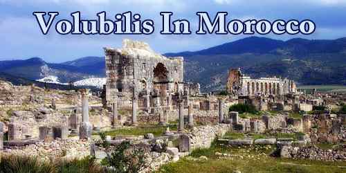
Volubilis (Berber languages: Walili, Arabic: وليلي), North African archaeological site, located near Fès in the Jebel Zerhoun Plain of Morocco. Built-in a fertile agricultural area, it developed from the 3rd century BC onward as a Berber, then proto-Carthaginian, settlement before being the capital of the kingdom of Mauretania. It grew rapidly under Roman rule from the 1st century AD onward and expanded to cover about 42 hectares (100 acres) with a 2.6 km (1.6 mi) circuit of walls. The city gained a number of major public buildings in the 2nd century, including a basilica, temple, and triumphal arch. Its prosperity, which was derived principally from olive growing, prompted the construction of many fine town-houses with large mosaic floors.
Under the Mauretanian king Juba II in the 1st century BC and the 1st century AD, Volubilis became a flourishing centre of late Hellenistic culture. Annexed to Rome about AD 44, it was made a municipium (a community that exercised partial rights of Roman citizenship) as a reward for supporting Rome during the revolt of Aedmon, and it became the chief inland city of the Roman province of Mauretania Tingitana. Ancient Volubilis and its hinterland were deserted about 285 when Diocletian reorganized Mauretania Tingitana. Known to the Arabs as Oulili, Walīla, or Walīlī, it became the capital of Idrīs I (founder of the Idrīsid dynasty) after 788.
The city fell to local tribes around 285 and was never retaken by Rome because of its remoteness and indefensibility on the south-western border of the Roman Empire. It continued to be inhabited for at least another 700 years, first as a Latinised Christian community, then as an early Islamic settlement.
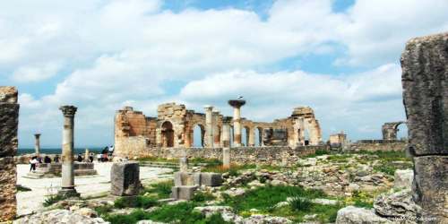
In the late 8th century it became the seat of Idris ibn Abdallah, the founder of the Idrisid dynasty and the state of Morocco. By the 11th century, Volubilis had been abandoned after the seat of power was relocated to Fes. Much of the local population was transferred to the new town of Moulay Idriss Zerhoun, about 5 km (3.1 mi) from Volubilis.
In the eighth century, when Islam arrived in the region, the churches were destroyed, although locals continued to occupy the city until the 11th century. While Volubilis remained inhabited and maintained its status as a capital city for centuries after the collapse of the Roman Empire, the city lost its administrative center status when nearby Fez was established, and the residents were relocated to the mountainous village of Moulay Idriss.
Built on a shallow slope below the Zerhoun mountain, Volubilis stands on a ridge above the valley of Khoumane (Xuman). It overlooks a rolling fertile plain north of the modern city of Meknes. The area around Volubilis has been inhabited at least since the Late Atlantic Neolithic, some 5,000 years ago; archaeological excavations at the site have found Neolithic pottery of design comparable to pieces found in Iberia. By the third century BC, the Carthaginians had a presence there, as evidenced by the remains of a temple to the Punic god Baal and finds of pottery and stones inscribed in the Phoenician language. The origins of its name are unknown but may be a Latinisation of the Berber word Walilt, meaning oleander, which grows along the sides of the valley.
The population of Volubilis is estimated to have been 20,000. Although the Romans lost control of the area by the 3rd century, they did not immediately abandon the city. Their Latin influence was evident for several hundred more years, up until the Arabs gained control of the region in the 7th century.
Volubilis remained an active and inhabited city until the 18th century. Although its historical structures suffered damage in an earthquake in the 1700s and some of its marble was taken for construction in Meknes, Volubilis is the best-preserved Roman ruins in all of Morocco.
A Muslim group known as the Rabedis, who had revolted in Córdoba in Al-Andalus (Andalusia in modern Spain), resettled at Volubilis in 818. Although people continued to live in Volubilis for several more centuries, it was probably almost deserted by the 14th century. Leo Africanus describes its walls and gates, as well as the tomb of Idris, guarded only by two or three castles. His body was subsequently removed to Moulay Idriss Zerhoun, 3 km (1.9 mi), where a great mausoleum was built for it. The name of the city was forgotten and it was termed Ksar Faraoun, or the “Pharaoh’s Castle”, by the local people, alluding to a legend that the ancient Egyptians had built it. Nonetheless some of its buildings remained standing, albeit ruined, until as late as the 17th century when Moulay Ismail ransacked the site to provide building material for his new imperial capital at Meknes. The 1755 Lisbon earthquake caused further severe destruction. However, English antiquarian John Windus had sketched the site in 1722. In his 1725 book A Journey to Mequinez, Windus described the scene:
“One building seems to be part of a triumphal arch, there being several broken stones that bear inscriptions, lying in the rubbish underneath, which were fixed higher than any part now standing. It is 56 feet long and 15 thick, both sides exactly alike, built with very hard stones, about a yard in length and half a yard thick. The arch is 20 feet wide and about 26 high. The inscriptions are upon large flat stones, which, when entire, were about five feet long, and three broad, and the letters on them above 6 inches long. A bust lay a little way off, very much defaced, and was the only thing to be found that represented life, except the shape of a foot seen under the lower part of a garment, in the niche on the other side of the arch. About 100 yards from the arch stands a good part of the front of a large square building, which is 140 feet long and about 60 high; part of the four corners are yet standing, but very little remains, except these of the front. Round the hill may be seen the foundation of a wall about two miles in circumference, which inclosed these buildings; on the inside of which lie scattered, all over, a great many stones of the same size the arch is built with, but hardly one stone left upon another. The arch, which stood about half a mile from the other buildings, seemed to have been a gateway, and was just high enough to admit a man to pass through on horseback.”
Volubilis’ location at the base of the Rif Mountains was both strategic and scenic. It was at the Western edge of Roman African, and the city’s position now overlooking the nearby town of Moulay Idriss allowed full view of the surrounding countryside.
The low mountainous region was ideal for growing olives and grains. Export of the region’s olive oil and wheat to Rome were central to Roman Africa’s economy. Some oil presses can still be seen in the ruins.
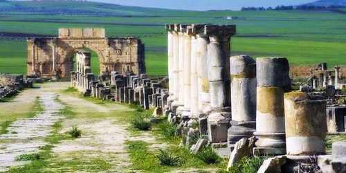
Visiting 95 years later in 1820, after the Lisbon earthquake had flattened the few buildings left standing, James Gray Jackson wrote:
“Half an hour’s journey after leaving the sanctuary of Muley Dris Zerone, and at the foot of Atlas, I perceived to the left of the road, magnificent and massive ruins. The country, for miles round, is covered with broken columns of white marble. There were still standing two porticoes about 30 feet high and 12 wide, the top composed of one entire stone. I attempted to take a view of these immense ruins, which have furnished marble for the imperial palaces at Mequinas and Tafilelt; but I was obliged to desist, seeing some persons of the sanctuary following the cavalcade. Pots and kettles of gold and silver coins are continually dug up from these ruins. The country, however, abounds with serpents, and we saw many scorpions under the stones that my conductor turned up. These ruins are said by the Africans to have been built by one of the Pharaohs: they are called Kasser Farawan.”
Expect a modest admission charge for the privilege of wandering through these historical ruins. Volubilis is an easy drive from both neighboring Moulay Idriss and the nearby Imperial City of Meknes. It can also be visited in day trips while en route to or from the cities of Fez, Rabat, and Casablanca.
In the 18th century, the Lisbon earthquake hit the region, which caused the destruction of the buildings. As early as the 1830s, well before the French Protectorate era, the French army began excavations. In 1997, the archaeological site of Volubilis was inscribed on the UNESCO World Heritage Site List.
Information Sources:
