Finding greenhouse gas emissions in the first place is a major challenge in reducing them to slow down climate change. Greenhouse gas emissions actually refer to the release of gases into the Earth’s atmosphere that trap heat and contribute to the greenhouse effect, leading to global warming and climate change.
Methane, an odorless, colorless gas that is currently the second most prevalent greenhouse gas in the atmosphere after carbon dioxide, falls under this category. Although it has a shorter life than carbon dioxide, according to the U.S. Environmental Protection Agency, it’s more than 25 times as potent as CO2 at trapping heat, and is estimated to trap 80 times more heat in the atmosphere than CO2 over 20 years.
“For that reason, curbing methane has become a priority,” said UC Santa Barbara researcher Satish Kumar, a doctoral student in the Vision Research Lab of computer scientist B.S. Manjunath.
“Recently, at the 2022 International Climate Summit, methane was actually the highlight because everybody is struggling with it,” he said.
Methane’s invisibility means that its emissions are probably not being fully documented, even though there are reporting regulations in the United States. The differences can be rather significant in some instances, as in the case of the Permian Basin, an 86,000 square mile oil and gas extraction sector in Texas and New Mexico that is home to tens of thousands of wells. Independent methane monitoring of the region has shown that the facility produces eight to ten times as much methane as the field’s operators have claimed.
The U.S. government is now looking for ways to tighten regulations over these kinds of “super emitting” leaks in the wake of the COP27 sessions, especially given that oil and gas output is anticipated to rise in the nation soon. To do this, however, a method for obtaining accurate fugitive emissions data must exist in order to evaluate the performance of oil and gas operators and impose the proper sanctions as necessary.
What we want to provide is an interface through a web platform such as BisQue, where anyone can click and upload their data and it can generate an analysis. I want to provide a simple and effective interface that anyone can use.
Satish Kumar
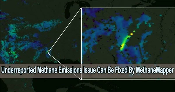
To detect real-time methane emissions and track them to their origins, Kumar and colleagues created MethaneMapper, a hyperspectral imaging tool powered by artificial intelligence. The tool functions by processing hyperspectral information obtained from aerial scans of the target area.
“We have 432 channels,” Kumar said. “Using survey images from NASA’s Jet Propulsion Laboratory, the researchers take pictures starting from 400 nanometer wavelengths, and at intervals up to 2,500 nanometers a range that encompasses the spectral signatures of hydrocarbons, including that of methane.”
Each pixel in the image represents a “spectral band,” or a range of wavelengths, and contains a spectrum. The enormous amount of data is then used by machine learning to separate methane from other hydrocarbons detected during the imaging process. The technique also enables viewers to view the source of the plume in addition to its size.
Companies are getting into the fray with equipment and sensor systems in the hot sector of hyperspectral imaging for methane detection. MethaneMapper is unique in that it collects a wide variety and depth of data from diverse types of terrain, enabling a machine learning model to detect the presence of methane against a variety of topographies, vegetation, and other backgrounds.
“A very common problem with the remote sensing community is that whatever is designed for one place won’t work outside that place,” Kumar explained.
As a result, a remote sensing program will frequently learn what methane looks like against a certain geography, such as the dry desert of the American Southwest, but pit it against the rocky shale of Colorado or the open plains of the Midwest, and the system might not be as successful.
“We curated our own data sets, which cover approximately 4,000 emissions sites,” Kumar said. “We have the dry states of California, Texas and Arizona. But we have the dense vegetation of the state of Virginia too. So it’s pretty diverse.” According to him, MethaneMapper’s performance accuracy currently stands at 91%.
The scanning portion of the system is being operated by MethaneMapper using aircraft. But the researchers have high hopes for a satellite-based program that might repeatedly scan larger areas of the landscape without producing the greenhouse gases that airplanes do. The major tradeoff between using planes and using satellites is in the resolution, Kumar said.
“You can detect emissions as small as 50 kg per hour from an airplane,” he said. With a satellite, the threshold increases to about 1000 kg or 1 ton per hour. But for the purpose of monitoring emissions from oil and gas operations, which tend to emit in the thousands of kilograms per hour, it’s a small price to pay for the ability to scan larger parts of the Earth, and in places that might not be on the radar, so to speak.
“The most recent case, I think seven or eight months ago, were emissions from an oil rig off the coast somewhere toward Mexico,” Kumar said, “which was emitting methane at a rate of 7,610 kilograms per hour for six months. And nobody knew about it.”
“And methane is so dangerous,” he continued. “The amount of damage that carbon dioxide will do in a hundred years, methane can do in only 1.2 years.” Satellite detection could not only track carbon emissions on the global scale, it can also be used to direct subsequent airplane-based scans for higher-resolution investigations.
In the end, Kumar and colleagues seek to make hyperspectral methane imaging and AI more widely used, making it accessible to a wide range of people even without machine learning experience.
“What we want to provide is an interface through a web platform such as BisQue, where anyone can click and upload their data and it can generate an analysis,” he said. “I want to provide a simple and effective interface that anyone can use.”
The MethaneMapper project is funded by National Science Foundation award SI2-SSI #1664172. The project is part of the Center for Multimodal Big Data Science and Healthcare initiative at UC Santa Barbara, led by Prof. B.S. Manjunath.
Additionally, MethaneMapper will be featured as a Highlight Paper at the 2023 Computer Vision and Pattern Recognition (CVPR) Conference the premiere event in the computer vision field to be held June 18-22 in Vancouver, British Columbia.