Hurricane protection science has advanced significantly in the last decade, fueled by an intensely destructive period of hurricane activity. The decade from 1996 to 2005 was one of the most destructive in history, with total hurricane damage totaling $198 billion. Researchers are looking into better ways to predict where the most severe road-clogging debris will be after tropical cyclones.
In the aftermath of a storm, safe and uninterrupted road travel is critical so that people can access medical treatment, downed power lines can be removed, and communities can begin to return to normalcy.
Researchers at the FAMU-FSU College of Engineering’s Resilient Infrastructure and Disaster Response (RIDER) Center are looking into better ways to predict where the most severe road-clogging debris will be after tropical cyclones. Their most recent publication was in the International Journal of Disaster Risk Reduction.
This research is especially relevant as hurricane season approaches because it reminds us that we need a variety of tools to properly respond to these storms. This paper describes an important tool and applies it to Florida Panhandle disasters.
Eren Ozguven
“This research is especially relevant as hurricane season approaches because it reminds us that we need a variety of tools to properly respond to these storms,” said Eren Ozguven, director of the RIDER Center and senior author of the paper. “This paper describes an important tool and applies it to Florida Panhandle disasters.”
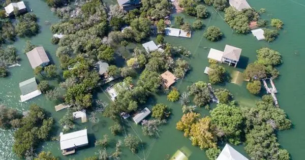
Researchers compared the amount of vegetation in Bay County, Florida, before and after two tropical storms and three hurricanes, including Hurricane Michael, a Category 5 storm that devastated the county in 2018. This gave them an estimate of how much vegetative debris was caused by the storms and where the debris was the heaviest. They were able to link debris measurements to variables like wind speed, initial vegetation amount, and roadway density.
The researchers discovered that debris was heavier in suburban and urban areas with a high density of people and roads than in rural areas. Although vegetation is not the only type of debris produced by a hurricane, it is an important predictor of where roads will become impassable.
Researchers hope to create a tool that will provide emergency management planners with an estimate of how much debris storms will produce, allowing officials to plan where to position trucks and collection zones ahead of storms.
“The faster you can get debris off the roadway, the better you will be in terms of getting back to normal after a hurricane hits,” said Tarek Abichou, a professor of civil and environmental engineering at the FAMU-FSU College of Engineering and co-author of the paper.
Along with knowing where to position resources prior to a storm, officials can use satellite imagery after a storm to quickly and cheaply assess post-storm damage before deploying first responders.
While the modern building code has evolved, millions of homes and commercial buildings in the United States were built prior to the adoption of modern building codes, putting them at high risk of hurricane damage. There are currently technologies available that allow older buildings to be retrofitted to become more hurricane resistant. Reinforcing gabled roofs, creating secondary water barriers in roofs, and installing hurricane straps and clips to ensure a roof stays in place despite high winds are all examples of these technologies.
The work is part of RIDER’s efforts to solve civil engineering problems with remote sensing technology. “Engineering is all about finding solutions in the face of obstacles, and hurricanes throw up all kinds of obstacles,” Abichou explained. “Improving our ability to prepare for and recover from storms using remote sensing will help us overcome those challenges.”