Fossil fuel plants are more likely to be found next to neighborhoods that were deemed unsafe during HOLC redlining, according to a team of researchers from the University of California Los Angeles and the Columbia Mailman School of Public Health.
Lara Cushing, Shiwen Li, Benjamin Steiger, and Joan Casey describe how they examined old maps of several significant American cities and contrasted them with weather patterns in the same areas over three significant time periods: 1940 to 1969, 1970 to 1999, and 2000 to 2020. Their findings were published in the journal Nature Energy.
In the same journal issue, Boston University School of Public Health’s Jonathan Levy released a News & Views article explaining the development of structural racism in the United States over the previous century and discussing the team’s work on this new initiative.
Prior studies have demonstrated that residents of urban poor neighborhoods experience higher levels of pollution exposure, which leads to greater health issues than residents of more affluent neighborhoods.
The fact that minorities make up the majority of the population in such locations further complicates the situation. The researchers examined one of the effects of redlining on specific urban regions in this latest effort.
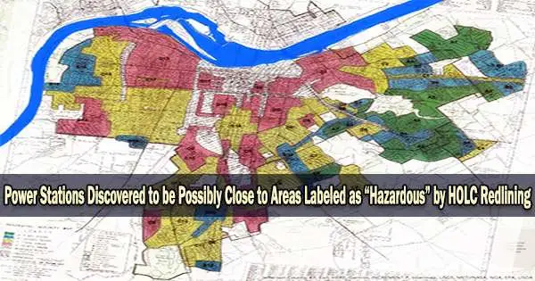
The Home Owners Loan Corporation (HOLC), a company, was founded in the 1930s. Its mission was to aid banks and other loan organizations by determining the risk of mortgage payments.
The HOLC produced colored maps of cities with various colored labels as part of their work. The most affluent, posh areas of the city were highlighted in green, while its most underprivileged areas were designated in red.
While it was simple for individuals purchasing in green areas to obtain loans, it was practically impossible for those seeking to purchase in red areas. The term “redlining” came about as a result of the difficulty this caused residents in these neighborhoods to have in selling their homes.
In this new study, the researchers questioned whether the HOLC maps, which were dismantled in the 1950s, may have had an impact on the placement of power plants and motorways in those times.
They looked at old maps of numerous large cities and compared the locations of fossil fuel plants with redlined areas to learn the answer. To identify the direction the pollution from such plants blew, they also took note of historical weather pattern movement.
Particularly after the Second World War, they discovered that such plants were more likely to be situated in or close to redlined neighborhoods, however they also discovered that such placement decreased in the years after the war.
Additionally, they discovered that exposure to greater concentrations of nitrogen oxide, sulfur dioxide, and particulate matter may be linked to redlining. They come to the conclusion that continued resistance has resulted in increased levels of this pollution in previously redlined areas up until the present.