Palaeogeography (or paleogeography) is the study of historical geography, primarily physical landscapes. It may also involve the study of human or cultural contexts. It entails reproducing ancient landscapes, climates, and geological settings from various eras in Earth’s history. When the emphasis is solely on landforms, the word paleogeomorphology is occasionally used instead. Paleomagnetism, paleobiogeography, and tectonic history are among its key tools. It is based on multiple lines of evidence, including geological data such as sedimentary rocks, fossils, paleomagnetic data, and isotopic studies.
Palaeogeography provides knowledge that is critical for scientific understanding in a range of circumstances. For example, palaeogeographical analysis of sedimentary basins is important in petroleum geology because historical geomorphological settings on the Earth’s surface are retained in the stratigraphic record. Palaeogeographers also investigate the sedimentary environment surrounding fossils for insights about the evolutionary development of ancient animals.
Key aspects of palaeogeography include:
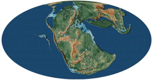
- Continental Drift and Plate Tectonics: Understanding the migration of continents across geological time is critical for reconstructing past geography. Plate tectonics theory explains how lithospheric plates move and interact, changing the positions of continents and ocean basins.
- Fossil Evidence: Fossils provide valuable information about previous ecosystems and organismal distribution. Researchers can learn about previous climates, ocean currents, and continent placements by examining the distribution of fossilized plants and animals.
- Sedimentary Deposits: Sedimentary rocks provide vital information about ancient habitats. Sedimentary architecture, particle size, and fossil content can all indicate the depositional environment, which could be rivers, lakes, deserts, or shallow oceans.
- Paleomagnetism: Rocks record the Earth’s magnetic field at the time of their formation. By analyzing the magnetic orientation of rocks, scientists can determine past latitudes and the positions of continents relative to the magnetic poles.
- Isotopic Analysis: Isotopic signatures preserved in rocks, such as oxygen and carbon isotopes, can provide insights into past climates, ocean temperatures, and the hydrological cycle.
Palaeogeography is furthermore crucial to the understanding of palaeoclimatology, due to the impact of the positions of continents and oceans on influencing global and regional climates.
Palaeogeographical evidence helped to develop continental drift theory and continues to inform current plate tectonic theories by providing information about the shape and latitudinal location of supercontinents like Pangaea and ancient oceans like Panthalassa, allowing for the reconstruction of prehistoric continents and oceans.
Palaeogeography is critical to understanding Earth’s history, including the evolution of life, historical climates, and the production of natural resources. It also sheds light on the driving factors underlying geological processes and the interactions of the Earth’s surface, oceans, atmosphere, and biosphere over millions of years.