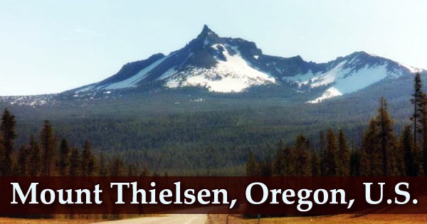
Mount Thielsen, sometimes known as Big Cowhorn (Klamath: hisc’akwaleeʔas), is a stunning horn-shaped peak located just north of Crater Lake in the Southern Oregon Cascades. It’s an extinct shield volcano near Mount Bailey in the Oregon High Cascades. Glaciers have significantly damaged the volcano’s structure after eruptive activity halted 250,000 years ago, creating steep slopes and a horn-like top. This summit is well-known for attracting lightning. The pinnacle of this mountain is frequently struck by lightning during storms, earning it the nickname “The Lightning Rod of the Cascades.”
The apex abruptly rises above its surroundings to form a distinct spire. Its north and east facades are particularly magnificent, rising nearly vertically 2200 feet. Thielsen’s spire-like structure draws lightning strikes, resulting in fulgurite, a unique mineral. There are no summits higher in the range until you reach the South Sister to the north and Mount McLoughlin to the south, but this is the reigning peak in this portion of the Cascades. The conspicuous horn serves as a focal point for the Mount Thielsen Wilderness, a recreational area that includes skiing and hiking.
Mt. Thielsen, with its top elevation of 9,148 feet, is an excellent location for a variety of recreational activities. In fact, it is the only spot where the waters of Crater Lake can be seen outside of Crater Lake National Park. Subduction of the Juan de Fuca Plate beneath the North American Plate generated Thielsen. Volcanic activity along the Cascades dates back 55 million years (mya) and spans British Columbia and California.
It is located on the east side of Diamond Lake, just across from Mount Bailey, which offers winter sno-cat skiing and snowboarding. It is located immediately south of Howlock Mountain, a steep peak that is the Diamond Lake area’s third highest mountain. Summer activities include hiking, backpacking, and fishing in high alpine lakes, while winter activities include backcountry skiing and snowshoeing. Thielsen is a member of the High Cascades, a branch of the main Cascades range that comprises many Oregon volcanoes that are less than 3.5 million years old, as well as a group of extinct volcanoes with sharp summits.
Mount Thielsen, despite its fearsome look, is a rather uncomplicated climb. The West Ridge is a thrilling route that isn’t too technical but has enough exposure to get your heart racing. The genuine summit is a magnificent spire that rises majestically into the sky. The ascent is not simple and needs a lot of hand climbing, but it is well worth it. A very tough climb is required to reach the peak of Mt. Thielsen, but it is well worth it for the amazing view at the finish.
Thielsen and the remainder of the Crater Lake area are strongly featured in 19th- and early 20th-century exploration. Mt. Thielsen’s South Entrance is only 1 mile east of Crater Lake National Park’s North Entrance, so there are lots of treks to choose from while visitors are there. Standing on the peak, the terrain appears to drop thousands of feet in virtually every direction, creating the impression of being suspended far above the Oregon Cascades’ lush forests. Most geologists estimate that activity in the Cascades has been sporadic, with up to 3,000 volcanic calderas forming at any given time.
Volcanic activity was common in the last 10,000 years, resulting in complexes ranging from Mount Garibaldi in British Columbia to the Lassen Peak complex in northern California. On a clear day, Mount Shasta and the Three Sisters may be seen to the south, and Mount Shasta and the Three Sisters can be seen to the north. Outside of Crater Lake National Park, the summit of Mount Thielsen is also the only spot where the waters of Crater Lake can be seen. The Cascade Mountains’ volcanic peaks are divided into two ranges: the High Cascades and the Western Cascades; Thielsen is located in the High Cascades, which are located east of the Western Cascades.
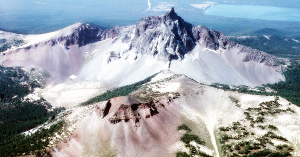
Despite the region’s humid environment, the forests on the mountain’s lower slopes are typical of drier regions. The porous nature of the volcanic ash in the soils accounts for this. Much of the rock on the mountain now is volcanic ash from Mount Mazama’s devastating eruption. The ash layer is between 12 and 60 feet thick, depriving the region’s trees of significant water. To the west of Mount Thielsen is Diamond Lake, caused by one of Thielsen’s eruptions, and beyond it is Mount Bailey, a considerably less eroded and younger stratovolcano.
The steep mountain of Thielsen dominates the skyline as seen from Crater Lake National Park. All three volcanoes are part of the Oregon High Cascades, a mountain range that separates Oregon’s younger than 3.5-million-year-old stratovolcanoes. Numerous lightning-caused scars known as fulgurites can be found on Thielsen’s summit pinnacle. On the top rocks, these wounds are made up of microscopic specks of obsidian-like glass. Some of the most pronounced fulgurites seem like splintered glass tubes that branch outward.
The Lathrop glacier, Oregon’s southernmost glacier, is also found atop Mount Thielsen. It is located in a little cirque at the base of the enormous north face of the mountain, which receives little sunshine. Thielsen is the highest of a group of extinct volcanoes in Oregon known as pyramidal peaks or “the Matterhorns” because of their steep, spire-like summits; at 9,182 feet, Thielsen is the highest (2,799 m). Mount Washington, Three Fingered Jack, Mount Bailey, and Diamond Peak are some of the other Matterhorn peaks.
Ensign E Hayden made the first reported ascent of Mount Thielsen in 1883. Hayden was part of a USGS team investigating the Cascade Range’s mountains. The remaining material in Thielsen’s crater collapsed, raising the crater’s youngest lava more than 1,000 feet (305 meters) above the active crater. Past lava flows on the mountain have varied in thickness, with some as thick as 33 feet (10 m) and others as thin as 1 foot (30 cm). Stack-like figures made up of breccia and previous flow deposits can be up to 328 feet thick (100 m).
The regular Mount Thielsen Trail is used by the majority of climbers. This is the finest option for a quick and easy day excursion. Miller Lake is another important feature of the Mt. Thielsen area. Miller Lake, which is relatively unknown to most people, is home to some of the best brown trout fishing in the Cascade Range. Miller Lake is unique in that it enables fishing 24 hours a day, seven days a week, allowing you to capture fish when they are most active, at night.
Information Sources: