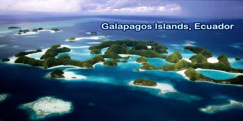
The Galápagos Islands (official name: Archipiélago de Colón, another Spanish name: Las Islas Galápagos, Spanish pronunciation: las ˈislas ɣaˈlapaɣos, local pronunciation: laz ˈihlah ɣaˈlapaɣoh), island group of the eastern Pacific Ocean, administratively a province of Ecuador. Part of the inspiration for the Theory of Evolution by Charles Darwin, this magnificent UNESCO World Heritage Site is one of the world’s leading places for wildlife viewing. Situated 906 km (563 mi) west of continental Ecuador, the islands are known for their large number of endemic species that Charles Darwin studied during HMS Beagle’s second voyage. His findings and collections led by natural selection to the inception of Darwin’s theory of evolution.
The Galapagos consists of 13 large islands (ranging in area from 5.4 to 1.771 square miles (14 to 4.588 square km), 6 smaller islands, and dozens of islets and rocks lying athwart the Equator 600 miles (1.000 km) west of the mainland of Ecuador. About 23,000 square miles (59,500 square km) of the ocean is spread their total land area of 3,093 square miles (8,010 square km). The islands have a population of slightly over 25,000. Its geographic position at the confluence of 3 ocean currents makes it one of the world’s richest marine habitats. The Archipelago of Galápagos is characterized by numerous contemporary volcanoes, some with sources of plume magma, some from the asthenosphere, probably due to the young and thin oceanic crust.
The ongoing seismic and volcanic activity reflects the processes that formed the islands. Together with the extreme isolation of the islands, these processes contributed to the creation of the unusual plant and animal life, such as marine iguanas, flightless cormorants, giant tortoises, giant cacti, exotic plants, and several different subspecies of mockingbirds and finches, all of which, following his visit in 1835, influenced Charles Darwin’s theory of evolution through natural selection. Parts of the Galapagos were designated a wildlife sanctuary by the government of Ecuador in 1935, and the sanctuary became the Galapagos National Park in 1959.
The islands were declared a UNESCO World Heritage Site in 1978, and the Galapagos Marine Resources Reserve was established in 1986 to protect the waters around them. Island ages are 0.05 Ma for Fernandina, 0.65 Ma for Isabela, 1.10 Ma for Santiago, 1.7 Ma for Santa Cruz, 2.90 Ma for Santa Fe, and 3.2 Ma for San Cristobal, from west to east. The Santa Cruz (Indefatigable) Island Charles Darwin Research Station supports scientific studies and preserves the Galapagos’ indigenous vegetation and animal life.
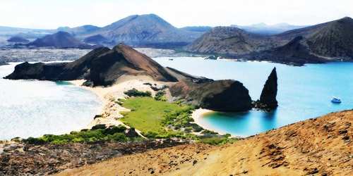
The islands are located within the eastern Pacific, 973 km (605 mi) off the West Coast of South America. The nearest landmass is that of continental Ecuador, the nation they belong to, 926 km (500 nmi) to the east. Unlike several other island destinations, each of the 21 islands of this archipelago has its own unique personality and anything from white beaches to volcanic rocks is seen by visitors/travelers. The striking ruggedness of the arid landscape is accentuated by high volcanic mountains, craters, and cliffs. Isabela (Albemarle), the largest of the islands, is approximately 82 miles (132 km) long and forms more than half of the archipelago’s total land area; it includes Mount Azul, the highest point on the Galapagos Islands at 5,541 feet (1,689 meters). The second-largest island is Santa Cruz.
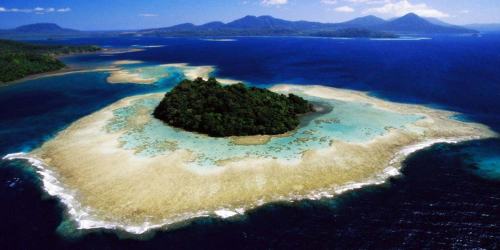
On the maps of Gerardus Mercator and Abraham Ortelius, the Galápagos Islands first appeared in around 1570. In reference to the giant tortoises found there, the islands were called “Insulae de Los Galopegos” (The Tortoises Islands). The islands were discovered in 1535 by Tomás de Berlanga, Bishop of Panama, whose ship had drifted off course while on its way to Peru. He named them Las Encantadas (“The Enchanted”), and in his writings he marveled at the thousands of huge galápagos (tortoises) found there. The islands are surrounded by the Galapagos Marine Reserve, established in 1986 (70,000 km2) and expanded in 1998 to its present location (133,000 km2), making it one of the world’s largest marine reserves.
Low rainfall, low humidity, and relatively low air and water temperatures define the climate of the Galapagos Islands. The islands are home to thousands of plant and animal species, the vast majority of which are endemic. The arid lowlands of the Archipelago are dominated by an open canopy of cactus. The Galápagos became parkland in 1959, and tourism started within the 1960s, imposing several restrictions upon the human population already living on the island. Around 30,000 people continue to exist in the islands, and approximately 170,000 tourists visit the islands annually.
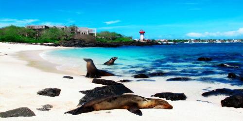
Sea-lion at Galapagos Islands, Ecuador
A transition zone at higher elevations is covered by a forest in which pisonia (a plant at four o’clock) and guava trees dominate, and the moist forest area above the transition zone is dominated by a thick Scalesia forest. Ferns and grasses are protected by the treeless upland region. In the 1990s and 2000s, violent confrontations between parts of the local population and also the Galápagos Park Service occurred, including capturing and killing giant tortoises and holding the staff of the Galápagos Park Service hostage to get higher annual echinoderm quotas.
Human inhabitants of the islands, mainly Ecuadorans, live in settlements on the islands of San Cristóbal, Santa María, Isabela, and Santa Cruz; Baltra has a military base in Ecuador. In the Galápagos, there are just 116 tourist locations: 54 land locations, and 62 scuba or snorkeling sites. Small groups are only permitted to visit in 2 to 4-hour changes, to reduce the area’s effects. All groups are in the course of licensed guides. a number of the islands are virtually untouched by humans, but many are altered by the introduction of nonnative plants, the expansion of the local human population, and tourist traffic.
Information Sources: