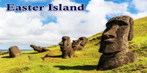
Easter Island, Spanish Isla de Pascua, also called Rapa Nui, the volcanic origin, is one of the fascinating but least visited archeological sites. The treeless island, located in the Pacific Ocean, is a small, hilly and remotest Island of the world. The awe-inspiring and stunning Island, covering 63 square miles of land, houses three extinct volcanoes in its territory. The tallest of all have a height of 1674 feet. The oldest and traditional name of this interesting site is “Te Pito o Te Henua”. The meaning of the name is the center of the world. In 1995, UNESCO named ‘Easter Island’ a World Heritage Site, with much of the island protected within Rapa Nui National Park.
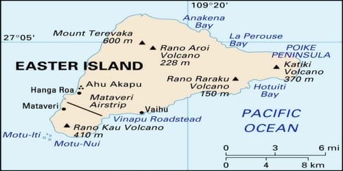
It’s not clear when the islands were first settled; estimates range from A.D. 800 to 1200. It’s also not clear how quickly the island ecosystem was wrecked but a major factor appears to be the cutting of millions of giant palms to clear fields or make fires. The island is about 24.6 km (15.3 mi) long by 12.3 km (7.6 mi) at its widest point; its overall shape is triangular. There are three Rano (freshwater crater lakes), at Rano Kau, Rano Raraku and Rano Aroi, near the summit of Terevaka, but no permanent streams or rivers.
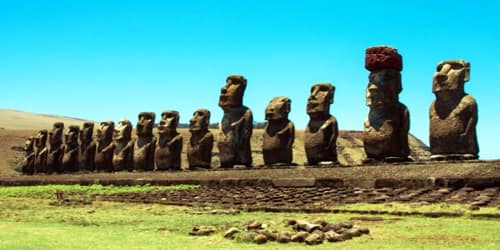
It is the easternmost outpost of the Polynesian island world. It is famous for its giant stone statues. The island stands in isolation 1,200 miles (1,900 kilometers) east of Pitcairn Island and 2,200 miles west of Chile. Forming a triangle 14 miles long by seven miles wide, it has an area of 63 square miles (163 square kilometers); its highest point, Mount Terevaka, is 1,969 feet (600 meters) above sea level.
“Rapa Nui” (“Big Rapa”) or Te Pito te Henua (“Navel of the World”), another name of Easter Island, was given by Tahitan sailor long back in the 1860s. The Island resemblance to another Island in Polynesia called Rapa Iti. According to that the name “Rapa Nui” was given. Jacob Roggeveen, the Dutch sea captain, visited the Island on Easter Sunday, on 5th April 1722 as the first European. The well-known name, Easter Island, has come from the Dutch sea captain.
The Easter Islanders are considered to be South-East Polynesians. Similar sacred zones with statuary (marae and ahu) in East Polynesia demonstrate homology with most of Eastern Polynesia. At contact, populations were about 3,000-4,000.
The small and hilly island is not part of a sunken landmass but is a typical oceanic high island formed by volcanoes rising from the seafloor. Geologic and oceanographic evidence shows that no perceptible emergence or submergence of the island’s coastline has taken place since the last fall in sea level, which occurred less than 10,000 years ago. Three extinct volcanoes chiefly composed of tuff (porous rock formed of compacted volcanic fragments) and joined by their own lava flows give the island its characteristic triangular shape. Parasitic tuff craters and cones (i.e., craters and cones formed on the side of, or near, volcanoes after the original vent has become plugged up) are interspersed in the landscape, which is otherwise dominated by eroded lava fields in which obsidian is commonly found. Most of these fields are thickly packed with both large and small lumps of cellular and tuffaceous lava that is either black or rusty in color.
The climate of Easter Island is classified as a tropical rainforest climate (Af) that borders on a humid subtropical climate (Cfa). The lowest temperatures are recorded in July and August (minimum 15°C or 59°F) and the highest in February (maximum temperature 28°C or 82°F), the summer season in the southern hemisphere. Winters are relatively mild. The rainiest month is May, though the island experiences year-round rainfall. Easter Island’s isolated location exposes it to winds which help to keep the temperature fairly cool. Precipitation averages 1,118 millimeters or 44 inches per year.
Winds in June and August are irregular; during the rest of the year trade winds from the east and southeast are dominant. From September through March the Peru (or Humboldt) Current, which has an average temperature of about 70°F (21°C), flows against the island. Occasionally, heavy rainfall and rainstorms strike the island. These occur mostly in the winter months (June-August). Since it is close to the South Pacific High and outside the range of the intertropical convergence zone, cyclones and hurricanes do not occur around Easter Island.
Previously the Island was full of compelling greeneries. It was the homeland of heaving birds and was the affluent breeding site of sea birds in Polynesia. Within a few centuries, all these trees were cut down and astonishing wildlife was destroyed. Now, it is a treeless paradise that has lost its old glory for the recklessness of human beings.
Easter Island’s population represents the easternmost settlement of a basically Polynesian subgroup that probably derived from the Marquesas group. The island’s traditional language is Rapa Nui, an Eastern Polynesian language, sharing some similarities with Hawaiian and Tahitian. However, as in the rest of mainland Chile, the official language used is Spanish. In their traditions, the islanders consistently divide themselves into descendants of two distinct ethnic groups, the “Long-Ears” and the “Short-Ears”. Intermarriage is common, and an influx of foreign blood has become increasingly dominant in recent years.
Information Source: