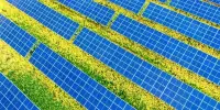
There are various tools and methods that can be used to map out the most suitable locations for developing clean energy infrastructure, such as wind and solar farms. These tools typically take into account factors such as the local climate, topography, and available land or water resources. They can also consider the proximity to existing transmission lines and the potential economic impact of the development. These tools help to identify the areas with the highest potential for renewable energy generation, and can aid in the planning and development of clean energy projects.
The Geospatial Energy Mapper, an update to the Energy Zones Mapping Tool, is an online tool with a large catalog of mapping data for energy planning. It can aid in the identification of areas suitable for clean energy infrastructure projects. The Geospatial Energy Mapper is an online interactive mapping tool that can assist in identifying areas across the country that are suitable for wind, solar, and other clean energy infrastructure projects.
It can be difficult to remember, or even imagine, life before most of us carried around a dynamic mapping platform in our back pocket. It has become second nature to be able to quickly map out the most efficient route by car, bike, or foot. What if the same principle of having an easily accessible and easy-to-use tool could be applied to mapping energy infrastructure?
The Geospatial Energy Mapper (GEM) is a comprehensive, interactive online mapping tool that can help identify areas across the country that are suitable for wind, solar and more. First publicly launched in 2013 as the Energy Zones Mapping Tool (EZMT), GEM has been redesigned, rebranded, and reengineered. GEM is hosted by the U.S. Department of Energy’s (DOE) Argonne National Laboratory with funding from the DOE’s Office of Electricity.
Choosing where to build utility-scale renewable energy development is a tremendously important decision with consequences that extend far beyond the generation of electricity.
Michael Levin
“In GEM we applied lessons learned from almost 10 years hosting the EZMT, including making it easier to learn and use, updating the software architecture, and choosing a name fitting its current scope of uses,” said Jim Kuiper, principal geospatial engineer, and GEM technical coordinator.
GEM has a large catalog of mapping data. This includes information about energy resources and infrastructure, as well as other information that could influence energy infrastructure siting decisions. Users can locate areas for clean energy generation, electric vehicle charging stations, and more using over 190 different mapping layers, including demographics, boundaries, and utilities.
One of the new features is mapping themes, which allow the map to be quickly configured for a specific focus, such as solar, wind, or electric vehicles. This new feature allows users to quickly load multiple layers associated with a specific technology or resource without having to manually search the mapping catalog and add individual layers to the map.

With GEMs modeling capabilities, users can generate a customized suitability map or “heat map.” This map shows which geographical areas in the United States are favorable for the development of certain energy resources and infrastructures. GEM includes preconfigured models for over 40 types of energy infrastructure. Land-based wind turbines or utility-scale photovoltaic solar are two examples. This provides a convenient starting point that users can then easily customize.
“Choosing where to build utility-scale renewable energy development is a tremendously important decision with consequences that extend far beyond the generation of electricity,” said Michael Levin, a GEM user, and Ph.D. student at Columbia University studying renewable energy landscapes. ? “GEM not only makes energy suitability maps available to the public, but it also allows the user to customize the model used to generate such a map.”
GEM has nearly 100 modeling criteria from which to choose. Population density, proximity to the nearest substation, slope, wildfire risk, and percentage of low-income households are just a few examples. For the development of clean energy resources, nine types of energy resources can be analyzed. Biomass, coal (with carbon capture and sequestration), geothermal, natural gas, nuclear, solar, storage, water, and wind are among them.
GEM, like the EZMT, is expected to have a diverse user base. Planners and regulators at all levels of government have used the tool. The EZMT, for example, was used by Kentucky’s Office of Energy Policy to prototype their Solar Site Suitability on Reclaimed Mine Lands tool. Private industry, public service commissions, and regional transmission organizations are among the other users. Finally, EZMT has been used by national laboratories, educational institutions, non-profit energy and natural resource organizations, and private individuals.