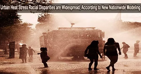
Cities are complicated, with spreading suburbia and highly populated metropolitan centres. Due to this intricacy, cities may experience temperature hotspots, with some neighborhoods (and the people who live there) experiencing greater heat than others.
The goal of recent study conducted by researchers at the Department of Energy’s Pacific Northwest National Laboratory is to comprehend this environmental mismatch. In a recent study that looked at all the main American cities, the authors discovered that the typical Black inhabitant was exposed to air that was 0.28 degrees Celsius warmer than the metropolitan average.
The average white urban inhabitant, in comparison, resides in a region where the air temperature is 0.22 degrees Celsius lower than the national average.
The new work, published last week in the journal One Earth, involved a two-part effort. The authors of the study hoped to create a more realistic picture of how our bodies react to outside heat and a more meaningful national estimate of urban heat stress. They also sought to learn more about which people are more vulnerable to urban heat stress by developing these estimations and contrasting them with demographic information.
The findings reveal pervasive income and race-based disparities within U.S. cities. Nearly 228 million Americans, or 94% of the urban population, reside in cities where the poor are disproportionately affected by summertime peak heat stress exposure.
The authors of the study also discovered that residents of historically redlined districts, whose loan applications had previously been turned down on the basis of race, would be more susceptible to outdoor heat stress than their neighbors living in historically non-redlined areas of the city.
The study also reveals flaws in the standard method that scientists usually use to calculate urban heat stress at these sizes, which heavily depends on satellite data. According to the new research, the traditional satellite-based method may overstate such inequalities. The research findings have the potential to influence urban heat response strategies proposed by local governments that aim to assist disadvantaged groups as the world warms.
Satellites give us estimates of land surface temperature, which is a different variable from the temperature we feel while outdoors, especially within cities. Moreover, the physiological response to heat also depends on humidity, which satellites cannot directly provide, and urbanization also modifies.
TC Chakraborty
What is heat stress?
The human body has evolved to operate within a relatively narrow temperature range. Once your core body temperature rises above six or seven degrees, there are immediate and severe physiological effects. Organ failure occurs as a result of cellular breakdown, cardiac strain, and organ failure.
Sweating helps. But the cooling power of sweating depends partly on how humid the environment is. When both heat and humidity are omnipresent and difficult to escape, the body struggles to adapt.
How is heat stress measured?
Scientists to measure heat stress use a number of indicators, many of which are dependent on air temperature and humidity. Weather stations provide such data. However, because most weather stations are located outside of cities, scientists frequently rely on alternative methods, such as sensors on satellites, to gain some sense about urban heat stress.
These sensors use measurements of thermal radiation to infer the temperature of the land surface. But such measurements fall short of delivering a full picture of heat stress, said lead author and Earth scientist TC Chakraborty. Measuring just the skin of the Earth, like the surface of a sidewalk or a patch of grass, said Chakraborty, offers only an idea of what it’s like to lay flat on that surface.
“Unless you’re walking around barefoot or lying naked on the ground, you’re not really feeling that,” said Chakraborty. “Land surface temperature is, at best, a crude proxy of urban heat stress.”
In fact, the majority of us are standing while navigating a world where the amount of humidity and air temperature determine how warm it truly feels. And these satellite data are only available for clear-sky days another limiting factor. More complete and physiologically relevant estimates of heat stress incorporate a blend of factors, which models can provide, said Chakraborty.
To better understand differences between satellite-derived land surface temperature and ambient heat exposure within cities, Chakraborty’s team examined 481 urbanized areas across the continental United States using both satellites and model simulations.
The land surface temperature was provided by NASA’s Aqua satellite, and the authors produced nationwide estimates of all the variables needed to compute moist heat stress using model simulations that take metropolitan areas into consideration.
The National Weather Service’s heat index and the Humidex, two commonly used measurements of heat stress by Canadian meteorologists, enabling the researchers to document the combined effects of air temperature and humidity on the human body.
They then identified heat stress hotspots across the country for summer days between 2014 and 2018. The scientists discovered connections between heat exposure and communities by superimposing maps of historically redlined neighborhoods and census tracts.
How is heat distributed within cities?
Residents in poorer neighborhoods often face greater heat stress. And in cities where income inequality is higher, the poorer citizens are frequently more exposed to heat stress.
Most U.S. cities, including heavily populated cities like New York, Los Angeles, Chicago, and Philadelphia, show this disparity. But the relationship between heat stress and race-based residential segregation is even more stark.
In about 87.5% of the cities examined, black people are concentrated in areas with higher air temperatures, higher land surface temperatures, and more moist heat stress. Moreover, the association between the degree of heat stress disparity and the degree of segregation between white and non-white populations across cities is particularly striking, said Chakraborty.
“The majority 83 percent of non-white U.S. urban residents live in cities where outdoor moist heat stress disproportionately burdens them,” said Chakraborty, “Further, higher percentages of all races other than white are positively correlated with greater heat exposure no matter which variable you use to assess it.”
In the 1930s, the U.S. federal government’s Home Owners’ Loan Corporation graded neighborhoods in an effort to rank the suitability of real estate investments. Lower grades (and consequently fewer loans) were given to communities made up of poorer and minority populations; this practice is referred to as ‘redlining.’ The authors find that these redlined neighborhoods still show worse environmental conditions.
The heat exposure in lower-rated neighborhoods is greater than in their non-redlined neighbors. Neighborhoods with higher ratings, in contrast, generally get less heat exposure.
This is in accordance with other studies on urban neighborhoods that had been redlined, which revealed less tree cover and higher land surface temperatures. Chakraborty, however, notes that using land surface temperature would generally overestimate these disparities across neighborhood grades compared to using air temperature or heat index.
“Satellites give us estimates of land surface temperature, which is a different variable from the temperature we feel while outdoors, especially within cities,” said Chakraborty. “Moreover, the physiological response to heat also depends on humidity, which satellites cannot directly provide, and urbanization also modifies.”
The findings are not without uncertainty, the authors added. “Ground-based weather stations helped to dwindle down, but not eliminate, model bias,” said co-author Andrew Newman of the National Center for Atmospheric Research, who generated the model simulations. The findings, however, remain in line with both theory and earlier extensive observational data.
What can be done?
Planting more trees often comes up as a potential solution to heat stress, said Chakraborty. But densely built urban cores, where poorer and minority populations in the U.S. often live, have limited space for trees.
The authors speculate that because many earlier predictions of vegetation’s ability to cool urban environments were likewise entirely dependent on land surface temperature, they may be susceptible to similar overestimation.
More robust measurements of urban heat stress would help, they added. How heat actually impacts the human body depends on factors like wind speed and solar insolation. But because they are challenging to detect or estimate at neighborhood scales, those characteristics are typically not taken into account in scientific assessments of urban heat stress.
In addition to Chakraborty, PNNL authors of the new work include Yun Qian. Andrew Newman at the National Center for Atmospheric Research, Angel Hsu at the University of North Carolina-Chapel Hill, and Glenn Sheriff at Arizona State University are also authors. DOE’s Office of Science and the National Institutes of Health supported this work.