Researchers at the University of Alaska Fairbanks have developed a method for remotely detecting massive landslides within minutes of their occurrence and determining whether they are near open water and pose a tsunami hazard.
They claim in a new study that their approach of detecting a landslide’s location, volume, and possible impact is fast enough to support the National Oceanic and Atmospheric Administration’s goal of providing a tsunami warning within 5 minutes of a landslide.
“The warming climate is causing glaciers to retreat, leaving behind valleys whose mountainsides and hillsides have lost their support,” said research seismologist Ezgi Karasözen of the UAF Geophysical Institute. “This is important, especially in regions like southern coastal Alaska, because huge masses of land can and do spill into water and cause tsunamis.”
Karasözen and Michael West, head of the Geophysical Institute’s Alaska Earthquake Center, described their method in a study published on February 9 in the journal The Seismic Record. West also works as Alaska’s seismologist.
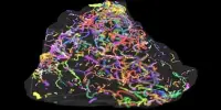
Their research highlights the hazard by using a 2015 landslide that deposited 100 million cubic yards of rock into Alaska’s Taan Fjord, which is located near Icy Bay 65 miles northwest of Yakutat. The fall caused a wave that stripped vegetation up to 620 feet above the waterline.
The warming climate is causing glaciers to retreat, leaving behind valleys whose mountainsides and hillsides have lost their support. This is important, especially in regions like southern coastal Alaska, because huge masses of land can and do spill into water and cause tsunamis.
Ezgi Karasözen
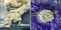
Karasözen and West’s prototype system for real-time detection has been in situ since August in the Barry Arm in Prince William Sound. It makes use of data from Alaska’s existing network of seismic stations.
State and federal agencies are concerned about a landslide and tsunami at Barry Arm, where Barry Glacier has receded, leaving behind an unstable fjord wall that has sunk roughly 650 feet in recent decades. A retrospective review of seismic station data from Barry Arm identified three landslides that occurred in 2020 and 2021.
Karasözen and West write that the instability “has prompted concerns that a catastrophic failure could generate a tsunami with several meters of peak wave height reaching nearby communities in just 20 minutes.”
The U.S. Geological Survey is leading the multifaceted interagency monitoring of the area.
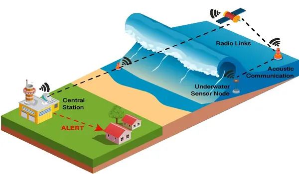
“With an earthquake, there are instruments that measure ocean wave heights, and tsunami warning centers are on alert after an earthquake,” Karasözen said. “But landslides aren’t systematically monitored in Alaska or elsewhere in the world. If a landslide-triggered tsunami were to happen, we wouldn’t know. That’s a major concern.”
The method by Karasözen and West involves quickly identifying a landslide’s long-period waves amid a seismic record busy with short-period waves created not only by a landslide but also by nearby earthquakes and glaciers and by human-caused activity.
A landslide’s initial beginning is typically characterized by short-period waves; it is not until the slide accelerates that identifiable long-period waves emerge. Landslides provide significantly more long-period energy than other sources. Most earthquake ruptures last only seconds, however landslides typically last a minute or more. Coastal fjords pose a substantial landslide detection issue since glaciers can generate hundreds of notable seismic events every day, according to the researchers.
Karasözen and West developed an algorithm that continuously scans seismic data from numerous seismic stations for a landslide wave signature. When they find a match, their method estimates the slide’s location and volume. In places with adequate seismic station coverage, the position can be predicted to within a few miles.
The technology is intended to inform tsunami and seismology agency officials, but additional work is required before that can happen. The two researchers developed the program by analyzing data from three recent Barry Glacier landslides as well as six other landslides, five of which occurred in Southeast Alaska and one on the west side of lower Cook Inlet, across from the Kenai Peninsula.
Other efforts have been attempted in recent decades. Several researchers have demonstrated that landslide seismograms can be used to predict position and volume, but these efforts were often limited to a specific region, required extensive fine-tuning, and were not intended for real-time applications. Because of the time it takes for seismic waves to reach distant seismic stations, determining the location of landslides cannot be done in real time.
West stated that the study complements ongoing monitoring and alarm activities. “The potential for real-time monitoring of large landslides is one important component of the interagency effort underway to address Alaska’s landslide challenge,” he told reporters.