Mount Tambora, also known as Tamboro or Gunung Tambora in Indonesian, is an active stratovolcano located in West Nusa Tanagra, Sumbawa Island, Indonesia, on one of the Lesser Sunda Islands. Tambora blew up in 1815, reaching a height of more than 14,100 feet (4,300 meters) and releasing 12 cubic miles of gases, dust, and rock into the atmosphere, as well as onto the island of Sumbawa and the surrounding area. Tambora’s eruption in 1815 was the greatest in human history and the greatest in the Holocene epoch (10,000 years ago to the present). Grasslands and woodlands were destroyed as rivers of incandescent ash rushed down the mountain’s sides. Tsunamis swept across the Java Sea as the ground rocked. Approximately 10,000 people died instantly on the island.
Previous eruptions had drained the magma chamber under Tambora, which had been dormant for decades as it refilled. The volcano is still active, with minor eruptions in 1880 and 1967, as well as increased seismic activity in 2011, 2012, and 2013. Tambora’s catastrophic eruption began with mild tremors and pyroclastic flows on April 5, 1815. The Tambora volcano erupted on April 10, 1815, producing the biggest eruption in recorded history. The explosion was heard more than 2,000 kilometers (1,200 miles) away on Sumatra Island.
Volcanic ash rains were seen as far away as Borneo, Sulawesi, Java, and the Maluku Islands, and Tambora’s greatest elevation was decreased from 4,300 meters (14,100 feet) to 2,850 meters (14,100 feet) (9,350 feet). A total of 150 cubic kilometers (36 cubic miles) of tephra erupted, resulting in rock and ash that could be seen for at least 1,300 kilometers (808 miles) to the northwest. The death toll was at least 71,000 individuals, according to various estimations. Climate scientists believe Tambora played a role in the unseasonably cold spell that hit much of the Northern Hemisphere in 1816, dubbed the “year without a summer.”
Tambora is part of the Sunda Arc, a group of volcanic islands that make up the Indonesian archipelago’s southern chain. Tambora’s eruption was ten times more intense than Krakatau’s, which was 900 miles away. Krakatau, on the other hand, is more well-known, partially because it erupted in 1883, shortly after the introduction of the telegraph, allowing word to reach swiftly. On Sumbawa, Tambora has its own peninsula, known as the Sanggar peninsula. The Flores Sea is to the north of the peninsula, and Saleh Bay lies to the south, measuring 86 kilometers (53 miles) long and 36 kilometers (22 miles) wide.
The volcano reached a height of roughly 4000 meters until a huge explosion devastated its summit more than 43,000 years ago, leaving a pre-1815 caldera. By around 10,000 years ago, lava flows had mostly filled the early caldera, and its activity had shifted to primarily explosive eruptions, culminating in the 1815 eruption. Mount Tambora is of interest to archaeologists and biologists, in addition to seismologists and vulcanologists who follow the mountain’s activity. Tourists come to the mountain for hiking and wildlife viewing, however in limited numbers.
According to Indonesia’s Directorate of Volcanology and Geologic Hazard Mitigation, climbing Tambora is too dangerous. As my guide would later tell me, the name of the mountain means “gone” in a local language, as in people who have vanished on its slopes. But researchers who have studied the volcano encouraged me. “Is it worth it?” I asked Steve Carey, a volcanologist at the University of Rhode Island, who has made the climb. “Oh, my!” he said. That was all I needed to hear.
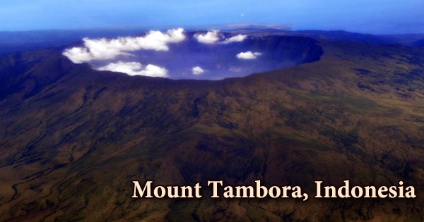
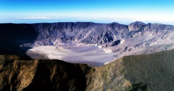
Around the mountain slope, there are three clusters of communities. Sanggar village is to the east, Doro Peti and Pesanggrahan villages are to the northwest, and Calabai village is to the west. During the April 10 eruption, Tambora’s estimated 4,000-meter (13,123-foot) high peak was removed, and the magma chamber below emptied, forming a massive caldera 6 kilometers (3.7 miles) in diameter and 1,100 meters (3,609 ft) deep. An ephemeral freshwater lake, recent sedimentary layers, and tiny lava flows and domes from the nineteenth and twentieth centuries now occupy the crater floor.
The volcano’s awful climax occurred on April 10th, 1815: three columns of fire erupted from the mountain, and a plume of smoke and gas stretched 25 miles into the atmosphere. It ejected a massive plinian eruption column into the stratosphere, reaching an estimated altitude of 40-50 km and ejecting enormous volumes of ash and aerosols. Winds caused by the fire uprooted trees. Pyroclastic flows, or incandescent ash, rained down the slopes at speeds of over 100 mph, shattering everything in their path and boiling and hissing into the sea 25 miles away.
Entire settlements were buried behind a thick layer of pumice. Archaeological digs have recently uncovered several of the towns, making the location a “Pompeii of Indonesia.” Large tsunamis with wave heights of 10 meters or more are possible. Tambora’s creation drained a vast magma chamber that had previously existed underneath the mountain. Saleh Bay first existed as a sea basin around 25,000 years ago, and the Mojo islet was developed as part of this geological process.
While the death toll among residents of Sumbawa and its neighboring coastal areas was already significant, the indirect effect of global climate deterioration following the eruption resulted in even more deaths. Apatite, biotite, clinopyroxene, leucite, magnetite, olivine, and plagioclase phenocrysts are found in volcanics, with the specific composition of the phenocrysts varied amongst rock types. Increased absorption of sunlight caused by a veil of aerosols (mainly tiny droplets of H2SO3 acid generated by SO2 emission) spread over both hemispheres by stratospheric currents from the tall eruption column was the cause of the climatic shifts. In 1816, global temperatures plunged by as much as 3 degrees Celsius, but recovered over the next several years.
The lowermost section has been deposited with interlayered lava and pyroclastic debris since the 1815 eruption. In the 1-to-4 m thick (3.3-to-13.1 ft) lava flows, about 40% of the layers are represented. Hundreds of miles away from the mountain, houses were destroyed by the rubble. Fresh water sources, which were always few, became contaminated. Crops and woodlands were destroyed. Minor lava domes and flows have been extruded on the caldera floor during the 19th and 20th centuries, indicating that Mount Tambora is still active. The most recent eruption was in 1967. However, it was a quiet eruption with a VEI of 0, indicating that it was non-explosive; another minor eruption occurred in 2011.
Scientists studying global climate trends, for example, use Tambora as a baseline, identifying the year 1815-1816 in ice cores from Greenland and Antarctica by their exceptionally high sulfur content signal of a huge upheaval long ago and a world away. In the East Indies, the Sumbawa people were famed for their horses, honey, sappan wood (used to make red dye), and sandalwood (for incense and medications). Agriculturally, the area was supposed to be extremely productive.
Information Sources: