Using cameras on transit buses to monitor traffic conditions is a practical and efficient solution that can benefit both public transportation systems and overall traffic management. The use of existing transit buses as data collection platforms eliminates the need to set up and maintain separate monitoring infrastructure, resulting in cost savings.
Researchers have proposed a novel method for counting and tracking vehicles on public roads, which could improve current traffic systems and help travelers arrive at their destinations faster.
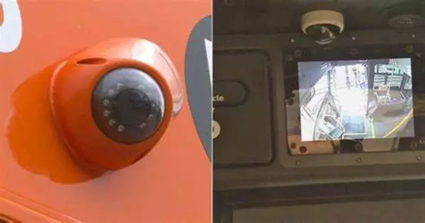
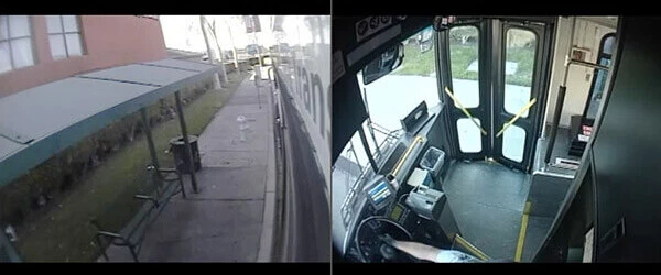
Researchers demonstrated that using cameras already installed on campus buses at The Ohio State University, they could automatically and accurately count vehicles on urban roadways, detect objects in the road, and distinguish parked vehicles from moving vehicles.
Previous research by Ohio State University found that using these mobile cameras provides much better spatial and temporal coverage than relying on sparsely and frequently placed sensors that do not provide a view of many streets and roads in a city.
Our goal is to start building a system that can do this without much manual intervention because it’s worth fully automating that process if you want to collect this information over a large number of potential vehicles and a long period of time.
Tom Holman
“If we collect and process more comprehensive high-resolution spatial information about what’s happening on the roads, then planners could better understand changes in demand, effectively improving efficiency in the broader transportation system,” said Keith Redmill, lead author of the study and a research associate professor of electrical and computer engineering at Ohio State.
Previously, researchers used human observers to manually identify the vehicles in the videos; however, this study, published in the journal Sensors, uses AI to automate the process.
According to study co-authors Mark McCord and Rabi Mishalani, both professors of civil, environmental, and geodetic engineering at Ohio State, their team chose to use the traffic cameras on the Campus Area Bus Service partly because Ohio State’s large, interconnected campus resembles a small city, and their relationship with CABS operators provided them with ready access to the collected videos.
“Sharing access to our bus cameras for traffic monitoring is a great example of how university operations can support research and learning,” says Tom Holman, director of Transportation and Traffic Management at Ohio State. “We are delighted to share existing resources that can generate useful data for long-term traffic planning on campus and elsewhere.”
But what distinguishes this study from similar traffic-related studies is that it makes use of free resources: bus cameras that were already installed for other safety and security purposes. According to Mishalani, this allows it to be easily integrated into how other cities manage traffic monitoring.
“If we can measure traffic as well as or better than what is currently done with fixed sensors, we will have created something incredibly useful at an extremely low cost,” he said. “Our goal is to start building a system that can do this without much manual intervention because it’s worth fully automating that process if you want to collect this information over a large number of potential vehicles and a long period of time.”
The system detects and tracks objects automatically by utilizing a cutting-edge 2D deep learning model called YOLOv4. According to Redmill, the program is also particularly adept at recognizing multiple objects in a single image frame.
While still a long way from total implementation, the study suggests the system’s results bear promise for the future of intelligent traffic surveillance. For example, besides counting vehicles, their algorithm is also able to project real-world bird’s-eye-view coordinates of the road network by taking advantage of streams of images, GNSS measurements, and regional information from 2D maps. It’s so precise, the system was also able to detect if the bus veered off from its planned route — and then report it to a map database that logs detailed information about the roadways, said Redmill, who is also a member of Ohio State’s Control and Intelligent Transportations Research Lab (CITR).
With widespread deployment and integration of their proposed approach, the vast collection and complete automation of processing of this data over time would allow for more effective planning, designing and operation of roadways to mitigate heavy traffic across the country. As for the benefits the public might see, such advancements in traffic surveillance could mean reduced travel times and greater travel choices when trying to get from point A to point B.