Background of the Coastal Road Project
The government of Bangladesh (hereinafter referred to as GoB) established the PRSP in November 2005 to set out a more strategic policy for reducing poverty for the purpose of achieving MDGs. In the PRSP, GoB proposes that achieving poverty reduction requires accelerating economic growth. With a goal to the above, GoB is seeking to achieve pro-poor growth by enhancing distribution of human resource and goods, and by promoting the private sector activities including the export industry through foreign direct investment. The economy of Bangladesh is relatively stable at present, and the GoB aims to boost real economic growth to 7% from the current 5% – 6% level.
Chittagong City, the second largest city in Bangladesh, is the backbone of Bangladesh industry with the country’s largest seaport, accumulation of industry and export processing zone. Therefore, the full utilization of its potential contributes to the development of Bangladesh. Although Chittagong City is recognized as an important area for Bangladesh development, there are various bottlenecks in infrastructure which prevent the smooth private sector activities. Among the bottlenecks, traffic congestion is the most urgent issue to be solved.
The existing trunk road system of Chittagong City is insufficiently developed compared to the volume of traffic in the City, and there are traffic safety issues due to a deficiency of sidewalks in addition to chronic congestion. City’s greatest infrastructure bottleneck is considered to be the inadequate development of roads and bridges. The development of a satisfactory truck road system is vital to the further growth of Chittagong City, one of the centers of industrial activity in Bangladesh.
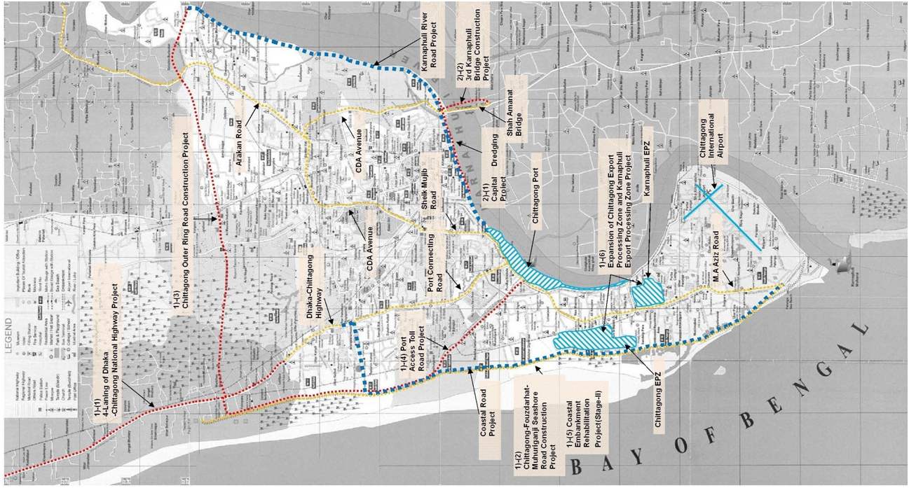
The JBIC Pilot Study for Project Formation in Chittagong organizes the issues to be resolved in the road sector and recommends the development of a trunk road network consisting of two ring roads and six radial roads as a future goal. The construction of the Outer Ring Road has an extremely important meaning in terms of mitigating the infrastructure bottleneck in the road sector.
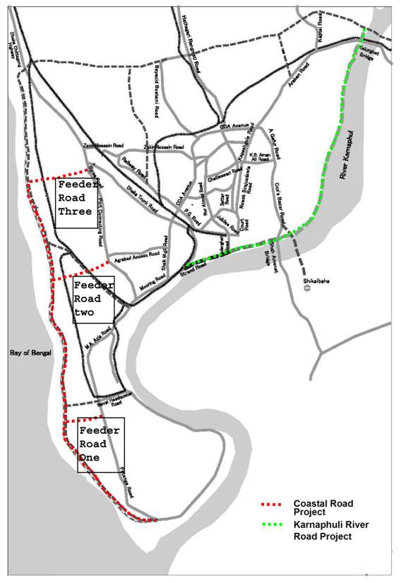
The CDA, which is responsible for development plans covering the Chittagong City and its environments, strongly recognizes the importance of the Chittagong Outer Ring Road. It has already commenced construction of the northern section of the Ring Road under the Outer Ring Road Project. The main sections now lacking are the Coastal Road section along the Bay of Bengal and the Karnaphuli River Road along the western bank of the Karnaphuli River. The construction of these sections is urgently required.
Bangladesh is extremely vulnerable to cyclones and other natural disasters. In 1970, a cyclone attacked the country and caused over 200,000 casualties. Another deadly cyclone in 1991 resulted in 140,000 casualties, of which 80,000 were in Chittagong. The City’s southern area was completely submerged, and there were enormous human and economic losses. Southern Chittagong has key facilities such as the Chittagong EPZ, an international airport and a seaport and functions as an industrial center of significance not only to Chittagong but also to the nation overall. It is also the most liable to experience damage from cyclones. It is important, in terms of ensuring the stable economic growth of Bangladesh, to implement measures to protect southern Chittagong from cyclones and other natural disasters.
The GoB, in its National Land Policy, sets forth the goals of improving the maintenance and management capabilities of road-related agencies, securing the necessary finance, and introducing various measures for improving transport safety, in addition to formulating a long-term road network plan. Meanwhile, in the area of disaster control, the Comprehensive Disaster Management Programme calls for the improvement of natural disaster prevention capabilities.
Against this backdrop, the GoB plans to construct the Chittagong Coastal Road, which is one of the most important components of the Chittagong Outer Ring Road and Chittagong trunk road network, as a road with the added function of bank protection. The objective is to improve the City’s disaster preparedness while simultaneously alleviating congestion in the City and reducing the infrastructure bottleneck that is hindering economic growth, thereby helping to attract more investments into the region and promoting further economic growth (JICA, 2009).
Objectives of the Project
(1) Alleviate road congestion in the inter city roads and improve transportation on the Dhaka-Chittagong corridor.
(2) Promote the private sector activities including export industry through foreign direct investment by improving the access to Chittagong city.
(3) Alleviate damages caused by cyclones and flood (Field Survey in CDA, 2012).
A Brief about the Coastal Road Project
The western section of the outer ring road of Chittagong city.
It is an embankment-cum-road.
From Patenga in the vicinity of the mouth of Karnaphuli River to Sagarika and is planned on the existing embankment to run along the coastline.
It is proposed in CDA Master Plan and JBIC Pilot Study executed in 2006.
Project Budget: 8562860 lakh tk
80% by JICA
20% by GoB
The sections of the project road, assumed future traffic volume(vehicle/ day) in high and low growth of the sections and required number of lanes for each volume has been collected by survey from the consultancy firm named Snow Mountain Engineering Corporation (SMEC), which has been supervised the engineering part of the project under CDA.
Table : Project Component
| Project Road | Section | Future Growth | Future Traffic (veh./day) | Required No. of Lanes |
| Main Road | Start Point – Feeder 1 | High | 12,000 or below | 2 |
| Low | 9,200 or below | 2 | ||
| Feeder 1 – Feeder 2 | High | 40,100 – 33,200 | 4 | |
| Low | 31,400 – 26,200 | 4 | ||
| Feeder 2 – Feeder 3 | High | 23,000 – 16,700 | 4 | |
| Low | 18,100 – 13,100 | 4 | ||
| Feeder Road | Feeder Road – 1 | High | 21,300 | 4 |
| Low | 17,000 | 4 | ||
| Feeder Road – 2 | High | 12,200 | 2 | |
| Low | 9,500 | 2 | ||
| Feeder Road – 3 | High | 16,700 | 4 | |
| Low | 13,100 | 4 |
Source: Field Survey in SMEC, 2012.
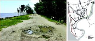
Resettlement Site
Kalshidighir Par Resettlement Site
Khujurtola Resettlement Site
Source: Field Survey in CDA, 2012
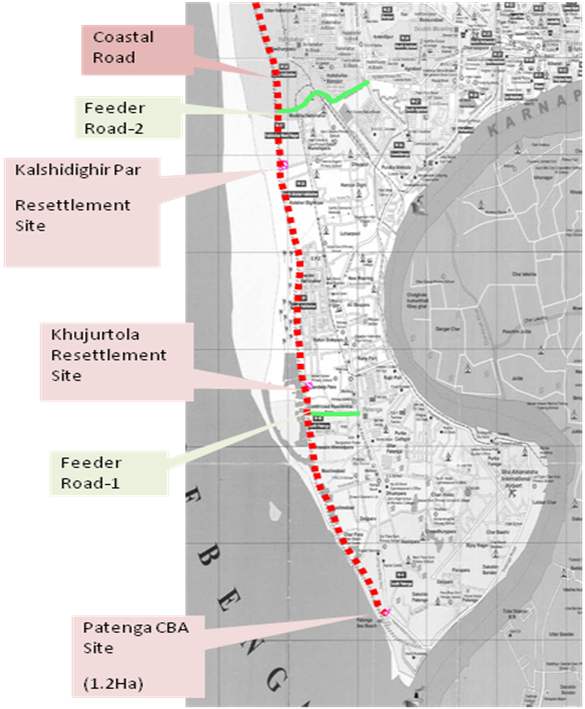
Pic:Location of Resettlement Sites
Descriptions about the main roads Along the Coastal Road of Chittagong
According to DAP (2008), DPZs 1 &2 are situated along the coastal road. So description of the roads of these DAPs has been illustrated below.
DPZ-1
The roads which are performing the functions of arterial network in this planning zone are: Port Road, Patenga Road, Chittagong Port Access Toll Road, Strand Road and part of Halishahar Road. Toll Road has recently been made operational to provide direct access from Dhaka Trunk Road to port area. The other important roads are Naval H.Q Road, Kathgar Road, Zelepara Road and Nayahat Road. Another important transport feature of this area isthe presence of two rail tracks, one connects the port and the other connects the Old Chittagong Steel Mill, presently known as Karnaphuli Export Processing Zone (KEPZ). In the road network system, it was observed that there are two important north-south roads (Patenga Road & Port Road), but there are no major east-west links. It was also found that the other internal roads are narrow; as a result the level of traffic circulation in this zone was considered to be very poor.
To address the problems and to develop a proper circulation pattern, the first initiative was to establish the primary and secondary road networks. The next step was to provide a proper internal circulation pattern so that mobility in the inner neighborhoods could be easier. Completion of a number of missing links and winding of several roads have, therefore, been proposed to establish almost a grid ironpattern of road system so that several alternative routes are available for movement within this planning zone (CDAP, 2008)
Proposals for new and widening of major roads in DPZ 1
- Embankment-cum-Road along the western coast: One of the most important primary roads proposed for this zone is the Embankment-cum-Road along the western coast from southern trip of Patenga to the north, parallel to Dhaka-Chittagong Trunk Road, having a Right of Way (ROW) of 120 ft for the road.
- Widening of Patenga Road and Port Road: Both these roads are already carrying heavy traffic, and in the future they will continue to be the primary roads and carry most of the traffic of thiszone. As such, widening has been proposed for Port Road, with ROW of 120 ft and Patenga Road with a ROW of 100 ft to be developed on an incremental basis, as per the geometric standards recommended by the DAP.
- Widening of the Link Road between Patenga Road and Port Road: The existing link road from the Halishahar and Patenga Road intersection, east of Chittagong EPZ to Patenga Road and Port Road intersection near National Cotton Mills, is proposed for widening with a ROW of 100 ft.
- Further widening of Port Access Toll Road: At present the Toll Road is a 2-lane access road. In future it will need widening for which a ROW of 100 ft is proposed to be earmarked.
- A number of new links between Patenga Road and the Embankment-cum-Road:
- A number of new secondary road links are proposed to provide access to the new Embankment-cum-Road along the coast. These will be developed based on a ROW of 60 ft and 40 ft.
DPZ-2
The primary north-south roads, which serve this zone, are the SK. Mujib Road (100 ft ROW), the Port Connecting Road (100 ft ROW), and the newly constructed Chittagong Port Access Toll Road(100 ft ROW), the Dhaka Trunk Road, which meets the Sk Mujib Road at Dewanhat Bridge. The major east-west roads are Agrabad Access Road (100 ft ROW), the Uttar Halishahar Road, the Madhya Halishahar Road and Sagarika Road. The east-west roads could be treated as secondary roads.
Road Hierarchy According to the Traffic Volume
In he “JBIC Pilot Study for Project Formation for Multisector Infrastructure Development in Chittagong” carried out roadside traffic counts at 10 locations along major roads in Chittagong City. Utilizing this data, general observations concerning traffic volumes in Chittagong are given below.
The Shaik Mujib Road has the greatest volume of traffic in Chittagong City. The road’s 12-hour traffic volume is as high as 44,000 vehicles (excluding non-motorized vehicles such as rickshaws). This is followed by the M.A. Aziz Road at 23,000 vehicles. The M.A. Aziz Road – Sheik Mujib Road – CDA Avenue axis is the most important road transport axis in Chittagong City. Traffic volume on this axis is high, and traffic congestion occurs frequently. The roads with the next highest traffic volumes are the Zakir Hossain Road, Dhaka-Chittagong Road, Arakan Road and Port Connecting Road, all of which experience over 10,000 vehicles of traffic every 12 hours (JICA, 2009).
All these roads, other than the Port Connecting Road, are radial roads linking with CDA Avenue, which serves an inner ring road in the City. Of the trunk roads discussed above, the M.A. Aziz Road, Dhaka-Chittagong Highway, and Arakan Road do not have alternative routes. The development of alternative routes for these roads is an extremely important issue.
Travel Speeds of the roads of Chittagong city
There is a study about the travel speed of the roads of Chittagong city by JICA in 2008. Travel speeds were surveyed along the section extending from Patenga to the City Gate, via the M. A. Aziz road, Port Connecting Road and Dhaka-Chittagong Highway.
The time period with the slowest travel speed was the 17:00 hour on nearly all routes, indicating the degree of traffic congestion during the evening peak hour. Routes with travel speeds of 10km/hour or slower, and therefore apparently the severest congestion, are the Sheik Mojib Road section in the Agrabad District and other sections shown in red in Figure 4.2. Travel speeds on CDA Avenue (National Highway 1) and major routes running inside the circle described by CDA Avenue are 20 km or slower in nearly all sections, including many with speeds of 10 km or less. The section from the Khulshi District to the GEO Intersection, one of the most congested intersections in the City, and the section near the Kalurghat Bridge are also heavily congested, with travel speeds at 10 km or slower. The congestion near the Kalurghat Bridge is due to highly inferior road facilities (including poor pavement condition) rather than to an excessively large traffic volume.
Traffic moved the slowest in the evening (16:00 hour or 17:00 hour), indicating that traffic volume is the heaviest in the evening peak hours. Similar results were obtained by the JBIC study carried out in 2005. In particular, the average travel speed of vehicles traveling in the Patenga to City Gate direction was 24 km. In the Chittagong EPZ and other sections where congestion is severe, travel speeds were 20 km or slower. (JICA, 2009).
Existing Land Use of Chittagong City
Chittagong lies approximately within a radius of 8 kilometers from the city center. Other than the sections along the Dhaka Trunk Road and the south bank of the Karnaphli River, nearly all the area falls within the city perimeter. Chittagong city, however, still has room for development in certain sections where urbanization has not progressed. In particular, considerable room for development is available in Chandgaon, located along the west bank of the Karnaphli River; in Bayazid Bostami in the northern part of the city; and the west side of Hathazari Rangamati Road. These sections are expected to be urbanized in the near future.
The west bank of the Karnaphli River is close to the central district and has high potential for development. The area has not been developed to any great extent, however, apparently due to the fact that it has suffered frequently from cyclone damage and has inferior bank protection.
The urbanized area of Chittagong city has spread outwards in response to pressure from population growth. A key issue concerning land use in the city is how to ensure systematic development in line with long-term visions for the city such as the Chittagong Master Plan, rather than allowing urbanization to progress in a disorderly fashion (CDAP, 2008)
Issues concerning land use in Chittagong include the following:
- Outward spread of the built-up area due to overcrowding in the city center.
- Illegal development of residential land and the construction of high-rises that violate the Construction Standards Law
- Illegal hill cutting and the resultant environmental deterioration such as slope collapses, debris flows and sediment deposition in khals.
- Flooding of areas located along the Bay of Bengal and the Karnaphli River.
- Insufficient number of open spaces and recreational facilities.
From the Existing land use scenario of the Study area, it can be seen that there is no major hilly area in the surrounding areas of the Coastal Road. But a great portion of the restricted area is situated in the southern zone of the city, which will be served by the Coastal Road after implementation. There is a railway line, runs parallel to the coastal road section from feeder road two to feeder road three.
In the eastern part of the city, there is Karnafully river, along which there is a plan of construction of the eastern section of outer ring road. This section will also be constructed as embankment cum road.Road Transport Development Policy in Chittagong
In June 2008, the “Detailed Area Plan (DAP) for Chittagong Metropolitan Master Plan” was completed. The DAP is based on the “Chittagong Metropolitan Master Plan,” which was formulated in 1995 and whose target year is 2015, and the “JBIC Pilot Study for Project Formation for Multisector Infrastructure Development in Chittagong” completed in March 2006.
The DAP mentions 11 measures pertaining to roads and highways, of which “Development of 2-Ring Roads for Better Distribution of Traffic” is listed at the top. As this indicates, the top priority transport measure of the CDA is the construction of the Inner Ring Road and the Outer Ring Road. The construction of the Coastal Road has the next highest priority after the two ring roads.
The Coastal Road and the Karnaphuli River Road, which are the Project Roads, have the higher priority among the measures planned by the CDA.
High priority road construction projects given in the DAP:
- Inner Ring Road (Shah Amanat Bridge to Strand Road section)
- Outer Ring Road (Dhaka – Chittagong Highway to Karnaphuli Bridge-4 near Kalurghat Bridge)
- Outer Ring Road (Karnaphuli Bridge-4 to Shah Amanat Bridge)
- Coastal Road (Mouth of Karnaphuli River to Dhaka to Chittagong Highway)
- Access Roads linking Outer Ring Road
- Access Roads linking Coastal Road
- Access Roads linking New Karnaphuli Bridge
Flood Prevention Policy in Chittagong City
The Chittagong Metropolitan Master Plan prepared in 1995 consists of four volumes, one of which is the “Chittagong Stormwater Drainage and Flood Control Master Plan.” Flood control measures given high priority in this master plan are listed in Figure 2.1‑1. The flood control measures take into account the fact that nearly the entire Chittagong built-up area was submerged during the 1991 cyclone.
The construction of an embankment along the Coastal Road and an embankment along the Karnaphuli River Road is among the top-priority flood prevention measures cited by the CDA (CDAP, 2008).
High-priority flood control measures given in the Chittagong Metropolitan Master Plan:
- Coastal Embankment along Bay of Bengal (Mouth of River to Fauzderhat)
- River Embankment (Mouth of River to Chittagong Port)
- Retaining Wall/Sheet Pile Wall (Chittagong Port to Shah Amant Bridge)
- River Embankment-cum-Highway (Shah Amant Bridge to Kalurghat Bridge)
- River Embankment (Kalurghat Bridge to Halda Bridge)