The global context and the climate is changing rapidly and this poses a major threat to the population and their habitat to cope with the changing dynamics of the surroundings. Hence, the habitat that house entire communities that in turn build entire nations need to be structured in a safe and robust manner that can easily adapt to adversity. These solutions can be achieved through architectural designs that are affordable, safe, socially /environmentally conscious, socio-culturally appropriate. This paper hence, highlights the architects as professionals who are not only the namesake for mainstream designs but are most vital components in the preparedness and reconstruction phases of the DM cycle capable of achieving sustainability and resilience through interventions.
The concept of architects and architectural interventions is seldom highlighted or appreciated in the disaster management cycle. Therefore, the thesis in its first chapter gradually unveils the concept of the disaster management cycle and its link to approaches that focuses mainly on interventions/solutions that are architecturally related to achieve sustainability.
The subsequent chapter clarifies the link between DM and architecture even further by show-casing examples of countries from all over the world that have been affected by destructive natural calamities and have benefitted through innovative designs. The case-studies were seen through the lens of an architect and the process of reconstruction of each example was outlined for different types of hazard. In doing so, the process revealed the different kinds of architectural interventions or creative solutions in detail that carry the potential of becoming catalysts for a sustainable future.
In the concluding chapter, the process was further analyzed for pros and cons and in this way ideas were presented as to how the projects or solutions can work more effectively and how it can be further improved. The essence of the thesis is to carry forward the concept of architectural innovations and its effectiveness in the DM system so that is can be adopted sooner to see a much more improved and “built back better” world in the approaching times of impending disasters.
BACKGROUND
Disaster is an irrevocable phenomenon that brings with it a string of destruction. It affects the human population, their property and their economical status. In other words, the destruction ravages through people, property and their positions costing their lives, homes and their morals. Nature- a pure architecture of the Almighty can never be tamed. It unleashes itself with unfathomable might and is unmatched. This rebellion of nature arises due to the constant impact it receives from mankind and their activities in the form of unplanned settlement and growing urbanization of cities; population growth in magnanimous proportion and aging infrastructure along with other debatable issues such as climate change and global warming. Disasters combine two elements: events and vulnerable people. (IFRC, 1993). Like they say- “without people there is no disaster”(O‟Keefe, Westgate & Wisner, 1976) and hence this climb in vulnerability of the human population is to a large extent due to the changes in the ecosystem and environment by men themselves. The rest is just because nature works in mysterious ways. Hence, should a hazard turn disastrous, it is very necessary to take appropriate steps by multi-disciplinary professionals towards sustainable goals.
Hazards can easily take shape of a disastrous situation and cannot be contained but it can be made bearable to the victims during its onset and long after it strikes. This can be done by increasing the adaptive capacity of individuals and the community through innovative and coping strategies and solutions. These solutions can be hence engineered in a more comprehensive and faster manner by architects and designers notably during preparedness and the reconstruction phase for a better and resilient tomorrow.
Yes, the two words “disaster” and “architecture” appear to be unrelated, history shows the connections. Marcus Vitruvius Pollio, a Roman architect in the 1st century BC, asserted that a structure must exhibit the three qualities of strength, usefulness, and beauty in his only surviving work De Architectura.(Murao, 2008). Architecture means “construction” or “evolution” of an idea or concept that can be implemented whereas „disaster” denotes “destruction” and “demolition” of matter or objects. One is useless, weak and unsightly without the other really. Just like the ying and yang – architecture plays a vital role in balancing out the destruction in the different phases of DM cycle and helps in establishing harmony within the chaos. This restoring of balance and harmony is sustainability and resilience and can be achieved through architectural interventions.
Even though, “Architecture “and “Disaster Management” is often viewed as separate disciplines belonging to different school of thoughts; these fields are actually branches of the same tree where the raw materials needed for its growth is the same. Architecture does not only mean practicing mainstream design concepts but its root lies in shaping up a community through design measures. Mainstream architecture maybe so called “trending” in the eyes of the regular mass but the fact that it can have a new meaning and style also cannot be undermined. Just like there are different styles in architecture in the likes of modern, traditional, deconstruction and so on-another interdisciplinary style may exist that is the blend of architecture and disaster management (Murao,2008). The literature on natural hazard mitigation directed toward the architectural profession is scarce in spite of the fact that architects can make a significant contribution to hazard risk reduction” (FEMA, A Manual for Architects, 2006). Even though, this topic is seldom discussed in literature-this particular paper advocates putting forth the relationship between architecture and disaster management and also explores how the former fits into each stages of the disaster management cycle.
Designers can play an important role in enriching users‟ lives by drawing on and respectfully using local cultural wisdom; making meaningful products through culturally appropriate design; facilitating cultural experiences (e.g., spaces for contemplation, peace, tranquility);incorporating and specifying local arts and crafts and local materials, products, and labor; and through socio-culturally inspirational design that becomes a pride of the community. Additionally, whether required or not, they can address intractable problems, and provide “socially conscious” elegant, affordable, culturally appropriate, imaginative, eco-sensitive, healthy, and safe solutions that make the project suitable for persons with disabilities, children, and the elderly, powerless, and poor.(Oliver 2003). Design professionals and the construction industry have a significant role in the health and safety of the environment and in disaster management .Their role includes a range of activities designed to maintain control over emergency situations, providing a framework for helping those who are at risk to avoid or recover from the impact of the disaster (Kelly, Limitations to the Use of Military Resources for Foreign Disaster Assistance, 1996).
STATEMENT OF THE PROBLEM
Since, architecture and disaster management are seldom linked in literature or in practice- the scope of the former in the latter is often overlooked. This is due to the fact that DM is a broad field and architecture may be a mere component. Nonetheless, if the stages were dealt with further scrutiny it can be asserted that it is the architect‟s capacity only to work within a “process” to come up with a sustainable solution rather than only a “product” during certain stages of the DM cycle (pre-disaster preparedness and post disaster recovery and reconstruction phases). In order to shed more light on an architect‟s scope of work during a disaster-this paper inspects the “how”(intervention techniques) and “why”(justification of intervention techniques) aspects and for “whom” ( people-centered & aimed at future generation)to achieve “what”? (resilience/sustainability).
OBJECTIVE
- An interdisciplinary field between architecture and DM is explored and that architects are one of the key contributors during a crisis is analyzed.
- To explore how designers can lead the way of seeing every project as a window of opportunity for future interventions.
- To investigate the relationship of the physical or built environment in the apt stages of the disaster management cycle.
- To investigate how socio-cultural inspirational design concepts (structural-non-structural) can facilitate efforts for a community to become truly “resilient” and “socially conscious” to become sustainable from future disasters.
RESEARCH QUESTIONS
- How and in what capacity can architects intervene to help build resilience and sustainability in the face of disasters?
- What kinds of architectural interventions can shape communities to become resilient and sustainable through creative solutions in both micro (individual household/structures) and macro levels (infrastructure and land-use or urban planning)?
- How can the refurbishment of policies by incorporating architect‟s and the role of architecture be instrumental in designing concepts and solutions for a more concrete-resilient future?
- How can mainstreaming the concept of “architects” and “architecture” in the form of education, awareness and participation prove to be an instrumental component in the DRMC to minimize risk in both the structural and non-structural issues?
SCRUTINIZING DISASTER
What is Disaster?
A disaster is an event, natural or man made, sudden or progressive, that seriously disrupts the functioning of a society, causing human, material or environmental losses of such severity that the affected community has to respond by taking exceptional measures. (adpc).
Disasters combine two elements: events and vulnerable people. A disaster occurs when a disaster agent (the event) exposes the vulnerability of individuals and communities in such a way that their lives are directly threatened or suffiecient harm has been done to their community‟s economic and social structures to undermine their ability to survive. It is an extreme but not necessarily abnormal state of everyday life in which the continuity of community structures and processes temporarily fails. (IFRC,1993).
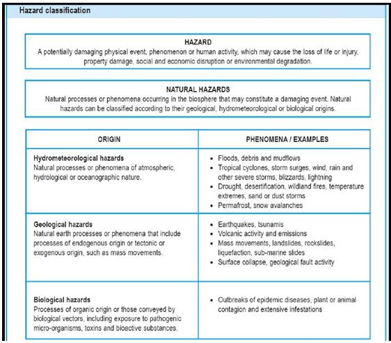
Hazard
Hazard is any substance, phenomenon or situation which has the potential to cause disruption, or damage to people, their property, their services and their environment.
In broader sense, according to (UN/ISDR,2004,)
A potentially damaging physical event, phenomenon or human activity that may cause the loss of life or injury, property damage, social and economic disruption or environmental degradation. Hazards can include latent conditions that may represent future threats and can have different origins: natural (geological, hydro -meteorological and biological) or induced by human processes (environmental degradation or technological hazards). Hazards can be single, sequential or combined in their origin and effects. Each hazard is characterized by its location, intensity, frequency and probability.
Exposure
Elements at risk, or an inventory of those people or artefacts that are exposed to a hazard. (UNDP, 2004) The degree to which a risk or portfolio of risks is subject to the possibility of loss. (MunichRe, 2004).
For instance, if one picks a community living in the coastal belts of Bangladesh and another living inland; then which community is more exposed to the threat of a hazard? The coastal community is more exposed to cyclone(hazard) and if physical infrastructure along with their livelihoods is damaged then it may turn into a disaster.
Another example of exposure would be as follows: A large number of homes and commercial buildings constructed prior to the 1980s were built with asbestos materials. Those products are considered safe as long as they are contained. But once ripped, broken and burned, blown or washed away, the products become a possible health hazard: asbestos exposure lays the groundwork for the human body to develop mesothelioma cancer years after the exposure. Soon after a natural disaster, these fibers may continue to circulate in the air, making them easily inhaled. Firefighters, law enforcement officials and cleanup crews are considered high-risk occupations for exposure after natural disasters. Homeowners of damaged properties also face these risks and should always use caution when cleaning or searching through debris.
Each natural disaster presents a particular set of circumstances. Hurricane Katrina in Louisiana and Mississippi, tornadoes in Alabama and Missouri, fires in California and flooding in Missouri and New Jersey from Hurricane Sandy are examples of natural disasters that officials fear exposed the public to asbestos.
Vulnerability
Vulnerability is a concept which describes factors or constraints of an economic, social, physical or geographic nature, which reduce the ability to prepare for and cope with the impact of hazards. (adpc)
The characteristics of a person or group in terms of their capacity to anticipate, cope with, resist and recover from the impact of a natural or man-made hazard. (IFFRC,1999)
Vulnerability is related to poverty. The poorest societies have the fewest resources and are usually the most vulnerable. However, while poverty is generally linked to income or availability of goods and degree of well-being based on wealth, the concept of vulnerability has a broader remit that also embraces cultural and social components. Not being poor does not necessarily means not being vulnerable, and vice versa. The average vulnerability of an individual is made up of a set of vulnerabilities connected to different social levels that each individual belongs to. The social levels are:
A)Individual, B)Household, C)Administrative community, D)National, E)Regional, F)Cultural community
For instance, the recent Balkans flood took the entire region by shock as countries in the Balkans have not faced such a situation before. Due to the recent phenomena of climate change, flood occurred unexpectedly and to everyone‟s surprise wrecking having to the economical, social, physical structures due to lack of preparedness. Even if communities were well-off at the individual, household, community levels, they fell short at the regional level due to climate change. Therefore, it can be said that the poor do occupy dangerous locations and are vulnerable at all times but the fact that the rich are vulnerable in some aspects cannot also be undermined.
Vulnerability can be dissected further into the following categories as shown in the diagram below. Three sets of links that connect the disaster processes that are located at decreasing levels of specificity from the people impacted upon by a disaster are as follows:
- Root causes
- Dynamic pressures
- Unsafe conditions
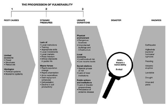
Figure. Showing the progression of vulnerability (Source: Aminur Rahman, BRAC University)
Risk
Risk is the probability of harmful consequences, or expected loss of lives, people injured, property, livelihoods, economic activity disrupted (or environment damaged) resulting from interaction between natural or human induced hazards and vulnerable conditions. Risk is conventionally expressed by the equation:
Risk= Hazard x Vulnerability x Exposure
Hence, risk is a combination of the interaction of hazard, exposure, and vulnerability, which can be represented by the three sides of a triangle.
If any one of these sides increases, the area of the triangle increases, hence the amount of risk also increases.
If any one of the sides reduces, the risk reduces.
If we can eliminate one side there is no risk theoretically BUT in reality-it is just not the case. There will always be risk and by reducing vulnerability, exposure and the impact of a hazard, a situation can be contained to a tolerable or acceptable level.
Earthquake- Geophysical hazard
Definition- Cause- Effect
An earthquake is caused by a sudden slip on a fault. The tectonic plates are always slowly moving, but they get stuck at their edges due to friction. When the stress on the edge overcomes the friction, there is an earthquake that releases energy in waves that travel through the earth’s crust and cause the shaking that we feel. It is also the sudden break within the upper layers of
the earth, sometimes breaks the surface, resulting in the vibration of the ground or lateral movements of the ground, which where strong enough will cause the collapse of buildings and destruction of life and property. Earthquakes strike with no early warning and can be devastating, but after a major one, aftershocks may be as strong as a new earthquake. They often trigger landslides, tidal waves and tsunamis. Powerful aftershocks frequently occur, causing further damage and increasing psychological stress. Earthquakes are measured according to the Richter scale – the most devastating effects are seen on level 6 and above, and if the epicentre of the earthquake is located in highly populated areas. Earthquakes can cause high numbers of deaths and injuries as well as serious destruction of buildings and infrastructure. Earthquakes cannot be prevented permanently. However, it can be minimized through preparedness initiatives such as land-use planning, innovative architectural designs for buildings, urban planning, development of possible warning indicators, land-use regulations, building regulations, relocation of communities, public awareness and education programs.
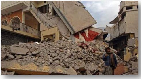
Figure. An earthquake affected area (Source: www.ifrc.org)
Cyclone/Hurricane/Typhoon – Hydro-meteorological hazard
Definition- Cause- Effect Tropical storms, cyclones, hurricanes and typhoons, although named differently, describe the same disaster type. Essentially, these disaster types refer to a large scale closed circulation system in the atmosphere which combines low pressure and strong winds that rotate counter clockwise in the northern hemisphere and clockwise in the southern hemisphere.The system is referred to as a “cyclone” in the Indian Ocean and and South Pacific, “hurricane” in the Western Atlantic and Eastern Pacific and”typhoon” in the Western Pacific. Hurricanes and typhoons are the same storm types as “tropical cyclones”(the local name for storms which originate in the Caribbean and China Sea region respectively).
A tropical cyclone is a non-frontal storm system that is characterised by a low pressure center, spiral rain bands and strong winds. Usually it originates over tropical or subtropical waters and rotates clockwise in the southern hemisphere and counter-clockwise in the northern hemisphere. The system is fueled by heat released when moist air rises and the water vapor it contains condenses (“warm core” storm system). Therefore the water temperature must be >27 °C. Cyclones, hurricanes and typhoons can be predicted several days in advance. The onset is extensive and often very destructive. These disasters are usually more destructive than floods. First, in a sudden, brief onslaught, high winds cause major damage to infrastructure and housing, in particular fragile constructions. They are generally followed by heavy rains and floods and, in flat coastal areas, by tidal waves.
In the case of cyclones, accurate landfall predictions can give only a few hours’ notice to threatened populations. In addition, people generally opt to wait until the very last minute before abandoning their home and possessions. Deaths from drowning in the high tides and sudden flooding and material losses are therefore often very high. “Apart from the human casualties that resulted from cyclone events, the damage to properties, which include physical infrastructure, livelihoods means and various direct tangible/intangible and indirect tangible/intangible items, is substantial. The continuum of loss and damage caused by these disaster events is very difficult to frame; it transcends the spatial and temporal boundaries. The population exposed to the risk of cyclones cannot afford shifting their settlements to a safer location since their livelihood activities are localized. Thus, after every cyclone the people, as if, “rise from the ashes” to get ready to face another.” (Shaw, Mallick, Islam, Disaster Risk Reduction Approaches of Bangladesh,2013)
Cyclones can be minimized through building multipurpose cyclone shelters, coastal afforestation and embankments, creating cyclone resilient structures, infrastructures and habitat and other innovative measures.
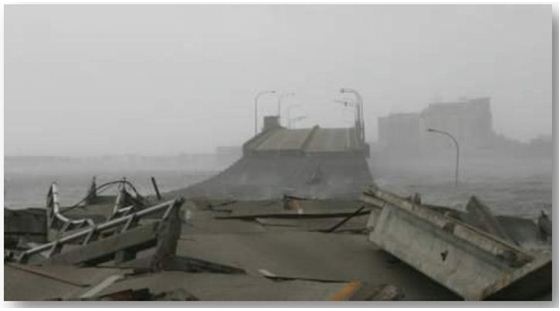
Figure. Cyclone ravaged coastal belt (Source: www.ifrc.org)
Flood – Hydro-meteorological hazard
Definition- Cause- Effect
General floods can be predicted in advance, except in the case of flash floods. The impact of flooding can include destruction of housing, crops, cattle and people. Flash floods are sudden and extreme volume of water that flow rapidly and cause inundation. Because of its rapid nature flash floods are difficult to forecast and give people little time to escape or to take food and other essentials with them. There are usually two phases following flood disasters. During the first phase, people crowd on patches of high, safe ground, together with cattle and other animals, even snakes and scorpions. Drinking water is often very difficult to find and sanitation is terrible. During the second phase, people start to move back to their homes as soon as possible. This is often a prolonged process (certain areas dry up quicker than others) and once home, people face new challenges including destroyed water systems, wells and bore holes that need cleaning up and disinfecting. A couple of weeks after the flood, high risks for epidemics like cholera, malaria and dengue emerge. Subsequent disasters caused by flooding would be landslides/mudslides and dam collapse. Homes, transport, tools, livestock and seeds are lost or destroyed in floods and cyclones, therefore, help with rebuilding and the restoration of livelihoods is a primary task.
Tsunami – Geophysical hazard
Definition- Cause- Effect
A tsunami is a series of waves caused by a rapid displacement of a body of water (ocean, lake). The waves are characterised by a very long wavelength and their amplitude is much smaller offshore. The impact in coastal areas can be very destructive as the waves advance inland and can extend over thousands of kilometers. Triggers of a tsunami can be: earthquakes, volcanic eruptions, mass movements, meteorite impacts or underwater explosions. The Japanese term for this phenomenon “tsunami” (“Wave in the port” in Japanese) , which is observed mainly in the Pacific, has been adopted for general usage.
Tsunamis cause massive devastation of physical assets such as housing, urban infrastructures and also ravages through people‟s livelihood. Springing back to normal state for a community may get very difficult if sustainable development is not practiced.
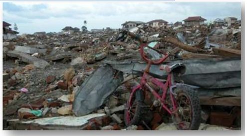
Figure. A tsunami devastated town (Source: www.ifrc.org)
Landslides – Geophysical hazard Downhill sliding or falling movement of cry soil and rock. Landslides are difficult to estimate as an independent phenomenon. It seems appropriate, therefore, to associate landslides with other hazards such as tropical cyclones, severe local storms and river floods. The term landslide is used in its broad sense to include downward and outward movement of slope forming materials (natural rock and soil). It is caused by heavy rain, soil erosion and earth tremors and may also happen in areas under heavy snow.
CYCLONE/ HURRICANE/TYPHOON
Cyclone Aila – May 25th, 2009
On the 25th day of March 2009, super cyclone Aila hit the coastal areas of Bangladesh causing severe damage to people’s livelihoods and homes, businesses, farming and agriculture leaving the people homeless and vulnerable. Habitats became inhabitable; embankments collapsed and agricultural land ruined due to salinity and inundation.
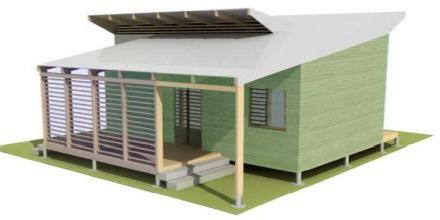
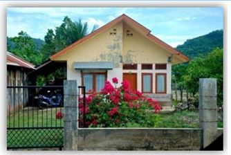
Disaster Resilient Habitat (Adarshagram, Sathkhira, Bangladesh)
In response to the carnage that the cyclone had brought about, architect Fuad Mallick together with architect Hasibul Kabir and students of architecture department of BRAC University conceptualized DRH(disaster resilient habitat) to strengthen an entire village and its community through innovative interventions such as cyclone-resilient houses and infrastructure. In this way, lives, livelihood assets could be protected and getting back to normal life would be easier. It was observed that even after two years people were still struggling to get back on their feet due to inadequate recovery activities. Therefore, the main goal of this habitat would be a “bottom-up” and “build back better” approach where communities having local skills would participate in harmony with the technical experts that would socially, physically, economically, ecologically boost up an entire village. Also, the cyclone-resilient habitat is an alternative solution to cyclone shelters that tend to be less efficient during and post-disasters.
The DRH is not just a “simple structure” or a mere “product”- it is a “process” that sees every structure as a cyclone shelter and the entire community as cyclone-resistant. A DRH comprises of an individual house that evolves to become a settlement.
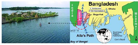
Figure: Map showing the path of Aila and post-Aila landscape (Source: Google image search/ Aila)
The project started up with a site visit that connected the team of architects from BRAC University with the local community. A workshop called the “dream house” was later held on site to understand the demands of the community in detail. The design process began with the villagers’ insight on their “dream home”. Later, to back up their thinking with the technical experts’ opinions, a second workshop was held at the Department of Architecture with representatives from the community to hatch even more practical solutions. The number of consultation sessions held led to an exchange of ideas and design developments began so forth.
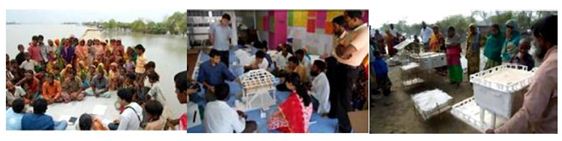
Figure. WorKshops on site & at the Department of Architecture ensured exchange of local and expert ideas (Source: Springer, CCA)
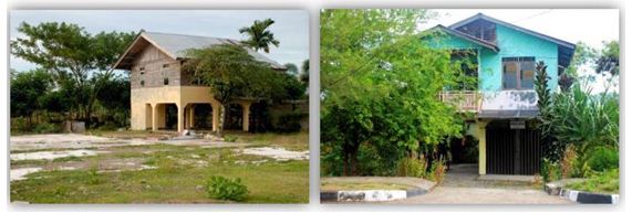
Following the sessions, the skills of the locals were identified who had great carpentry skills most of them being boat makers. Also they were introduced to the reinforced concrete constructions by the technical experts. This amalgamation of local and technical knowledge and skills reflected upon a design solution that consisted of a reinforced concrete frame structure upon which would rest another timber frame structure which would eventually act as the “shelter” during storms. The structure would be a mixture of modified concrete, locally available timber from plantations in the site that had been replanted later on and clay tiles for roof. A total of 43 houses and a school replacing the one that was destroyed would be built in Adarshagram.
The first test house was built and this ensured that the experience gained while building it would be carried on to build the next houses even stronger. The building process began by digging trenches for foundations by laborers after which the laying of brick over sand was entrusted to the house owner. Skilled labor was used to lay reinforcement bars and minor tasks such as bar binding or tying were handed to the locals. The boat makers or homeowners’ skills were used to make the strong timber frame structure whereas the concrete construction was supervised by the engineers and undertaken by skilled labors together with student volunteers and local men and women.
The houses were 10 ft by 13ft and of height 8 ft and were built on four concrete columns joined by reinforced concrete beams well above flood level. The beneficiaries wanted the structure to be above ground with empty space below for modifications and future extensions. Stones instead of bricks and a special chemical were used in the mixture to make the concrete saline resistant. Also, extra gaps were left to prevent steel bars to rust and expand due to salinity. The salinity was caused because the embankments were breached by the villagers for shrimp farming. Again, the homeowners’ were given responsibility of providing fresh water while casting concrete. Then, metal clamps were placed inside the concrete beams upon which the timber frame structure was placed. The joineries to attach the timber to the concrete frame were figured out on situ by both the experts and the locals. The timber structure was further strengthened by cross-bracing on all four sides. The roof was supported by wooden truss and strengthened by closer purlins at the roof edge. It was then attached to the concrete frame by special metal straps known as “cyclone straps”. The roof was finished with locally available clay tiles with each of them screwed onto the wooden frame below to prevent it from being blown away in high winds.
The habitat planning is such that the tip of the water is lined with mangrove shrubs and trees to protect from intense wave action. At the water edge, the path come working space which is the access to and from the habitat is fringed with productive trees. At the tree edge begins the homestead where some space is utilized for growing vegetables and the house or “shelter” occupies the rest of the area. The houses are raised on filled earth from pond digging and the dug out pond is commonly used for fish cultivation .The pond is located at the center of the habitat fringed with trees, herbs and shrubberies. Solar panels and rainwater harvest system are also part of the design scheme of the habitat.
“We know how to build strong houses; the challenge is building stronger communities,” is what that lead architect of the DRH said. A more comprehensive bottom-up approach which is a combination of technical expertise, local skill and people’s participation is needed to make a community both structurally and ecologically strong. Recovery here does not mean only building one house but its surroundings too.
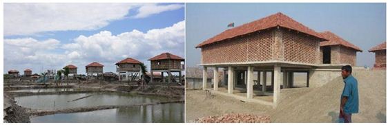
Figure. The Disaster-Resilient Habitat & the completed adjoining school (Source: Google Image Search/ Aila)
- Typhoon Xangsane– 2006
Typhoon Xangsane caused significant damage to the masonry shelters of the Port city of Da Nang in Vietnam. There were significant adverse impacts on all levels and scales of the social-physical-economic systems. The lack of awareness of people about new building technology and materials led to the easy collapse of houses.
Individual houses- Settlement Planning (Da Nang Port City, Vietnam)
A competition took place seeking disaster resilient housing-design ideas in Vietnam with focus on Da Nang City. The team of architects had addressed three points that needed to be considered:
1) Site- Planning: Site-planning and settlement patterns are designed with the emphasis of using nonparallel or zig-zagging roads and unequal distribution of houses.
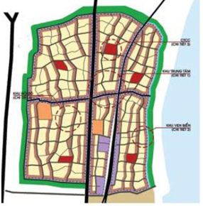
Figure. Site planning : Zig-zag pattern for roads & buildings (Source: ISET, 2013)
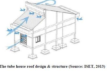
2) Building Design: Simple building shapes such as squares and rectangles and high-sloping pitch roofs are employed as key principles to design individual houses for storm reduction. Based on findings through field visits, architects decided to work with three types of house forms: a) the tube-house, b) three-compartment structure and c) twin-double storey buildings.
3. Construction Technology: While designing, the architects highlighted two basic principles: (a)all building parts were connected from top to bottom by reinforced-concrete beams and pillars and (b) a strong room known as “safe failure” was incorporated in each house which could be used for escape during calamitous typhoons.
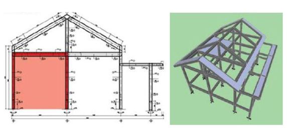
Figure. Building technology: Safe failure or solid room and all parts of the building securely connecte (Source: ISET, 2013)
The team’s approach of the design was to maintain the local design forms of all the houses but to incorporate new and innovative construction techniques to increase technical stability.
FLOOD
Annual Flooding
Almost 60% of the land is inundated due to flood waters in Bangladesh resulting in destruction of homes, livelihood capacities. The rural population has been living with flood for ages and it is slowly becoming a major nuisance in the urban areas or cities. Nonetheless, in rural areas communities have adopted their own coping methods but lack the technical knowledge and have wrong perceptions. Henceforth, designers and building professionals have devised ways to combine the age-old techniques with technology in the existing typologies to come up with cost-effective, quality and sustainable designs.
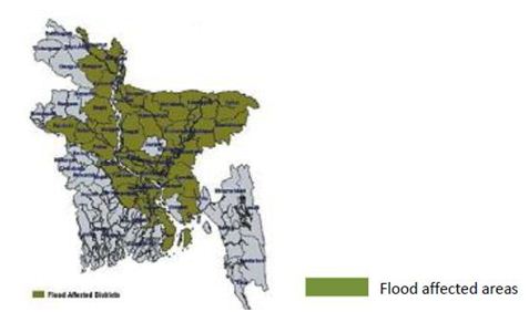
Figure: Flood affected areas in Bangladesh, 2004 (Source: Wiki/BD Flood)
Individual houses- Homestead & Infrastructure planning- Landscaping (Flood –prone areas, Bangladesh)
Individual Houses:
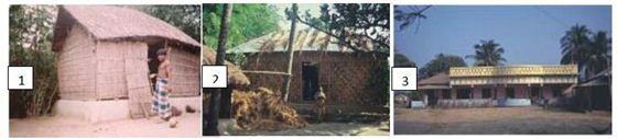
The basic designs of rural houses are as follows:
1) Kutcha house
a) Foundation: Usually earthen plinth and bamboo or timber posts;
b) Walls: Organic materials such as jute, catkin grass, straw, bamboo mat reinforced by split bamboo framing and sometimes earthen walls;
c) Roof: Thatch-rice/wheat or maize straw with split bamboo or reed stalk framing.
Flood affected areas
2) Semi-Pucca house
a) Foundation: Usually earthen plinth; brick perimeter wall with earth infill; brick and concrete;
b) Walls: bamboo mats; CI sheet; timber or split bamboo framing and sometimes earthen walls; sometimes part or full brick
c) Roof: CI sheet with timber framing (split bamboo sometimes)
3) Pucca house
a) Foundation: brick and concrete;
b) Walls: brick
c) Roof: Reinforced concrete
The typical problems due to flood are outlined for walls, foundation and the roof.
For foundations, in kutcha types, the earthen plinth tend to get completely washed off and the bamboo or timber posts embedded into it are very weak. The whole building loses stability and collapses during even moderate flood. The in-fill earth floor for semi-pucca structures can experience the escape of soil from below during prolonged floods. For pucca houses due to scouring foundation can weaken.
For walls, in kutcha & semi-pucca houses the bamboo walls decay easily. CI sheets corrodes in contact with water and for earthen walls the whole structure is liable to collapse as flood waters cause serious damage to monolithic construction. Brick walls can experience peeling of plaster, weakening of mortar joints and staining. Cracks develop if the foundation settlement occurs due to prolonged flooding.
Urban settlement / Housing ( Banda Aceh, Indonesia)
Banda Aceh is a low-rise metropolis along the delta of the Aceh River. Due to its low-lying plains the anti-poverty network called UBA (Uplink Banda Aceh) took strong stance to reconstruct the village where the villagers previously lived. In this case study, Uplink worked with the technical persons (architects and planners) along with the local residents. The villagers decided to stay back in their former settlements close to their livelihood and hence the plans were devised accordingly.
Firstly, the pre-tsunami village demographic characteristics were documented and the post-tsunami areas surveyed for their strengths and weaknesses to better target recovery efforts. Then locally a group was formed where enough wood from the tsunami debris was collected to build temporary shelters through participatory effort before turning the structures into permanent houses. Jakarta architect Marco Kusumawijaya worked with UBA and decided to keep the mosque-centered layout of the previous settlement and build upon it. Most people wanted a “clean slate” of land to start the building process but the architect decided to keep the structure and the road pattern of the original village intact to value the culture and tradition of the area. These previous attributes were adjusted by providing enhancements like better escape roads, access to quality land that could enable move to a higher elevation.
The houses provided were a combination of single and double-storey houses. The single storey houses had RCC (reinforced cement concrete) foundations and structure whereas walls were made of brick with wooden frames and shutter for doors and windows and sometimes glass shutters were used. The gable roof’s structure was that of wood covered with tin.
The two-story homes were raised above the ground and this design offered greater protection from floodwaters or minor tsunamis, while yielding a covered, protected space on the ground floor that could be used to store fishing and farming equipment or support a small business. The reinforced concrete columns provided the structure with greater stability from hydro-dynamic forces of the tsunami whereas the upper wooden floor reduces lateral movements of an earthquake.
Individual houses—Settlements & Landscaping (Kirinda, Sri Lanka)
Following the Tsunami of 2004, the Muslim village of Kirinda in Sri Lanka, a small fishing community lost majority of the houses and residents were forced to live in temporary accommodations. In the aftermath architect Shigeru Ban designed the settlement with the goal to relocate residents back to their former homes and livelihood so to retain the pre-disaster social and cultural structure of the village.
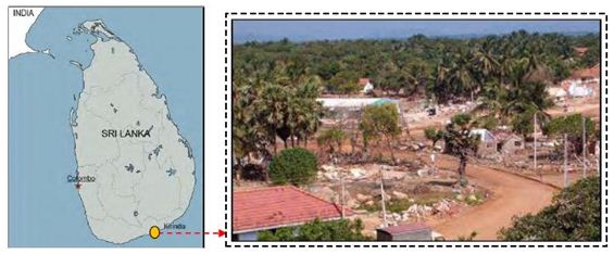
The Architect and his team surveyed the local architectural character, site and surroundings, climatic conditions, historical background and topography to come up with appropriate solutions for the housing settlement. The following observations were made:
– Kirinda is a popular place for pilgrims because of its legendary stories,
– The livelihood of people comprises of fishing and diving for sea-shells,
– The climate is such that no heating is required in the household and precipitation occurs of 30 mm.
– The project site is located 200m from the Indian Ocean .The main road runs through the centre of the site that branches into smaller roads. The critical civic facility which is the mosque is slightly north off the centre and was severely damaged and a Buddhist temple sits on an elevated position close to the project site.
– The surrounding landscape includes dust/green areas, shrubberies and palm trees around the houses and at the verges of the roads. Kirinda is usually a level site and the village’s buildings were arranged in rows. The site also features three ponds/lakes on either side of the main road.
With this information, an appropriate architectural master plan was laid out and the evolution of the design concept began.
LANDSLIDE
Peradeniya landslide – 2009
Peradeniya is a hill country situated in the intersection between Nuwera eliya and the historic city of Kandy. It is known for its scenic beauty with the Mahevela River on the east and the mountains in the west and is a tourist spot. Its location is on the landslide prone slide as natural slope was modified to build the Colombo-Kandy. The place has a lot of commercial and residential activities within the reservation area which needs to be resettled. Hence, a hypothetical design was thought where architectural interventions and engineering together would create a landslide resilient resettlement urban center with socio-economic values while re-arranging the physical setting of the town.
Resettlement of Urban center to Future communities (Peradeniya, Sri Lanka)
The landslide in Peradiniya is such that soil layers and soil banks tend to break away and the top soil layer was weakened due to unplanned settlement. To create the urban center, the top soil susceptible to erosion was removed and so was the soft or nice layer of rock (granite layer) beneath which exposed the hard layer of rock to build on. The top soil was cleared in the form of steps sloping down towards the river. Drip ledges were created enabling the storm water to be drained naturally and the toe of the hilly site would be reinforced by large rock debris from the removal of the nice layer of rock. The space created by removal of soil is to be carefully integrated for the architectural intervention- the urban center.
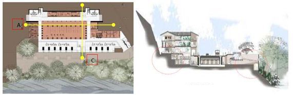
Figure. Plan & Section CC (vertical) showing the stepped slopes and retaining walls (in red circles)(source: Dilshan, university of Moratuwa, Sri Lanka)
The removed granite is to be re-used for construction of the new building and the soil is to be utilized for landscaping. Bricks are being used for the construction instead of concrete to regulate the temperature in a more eco-sensitive manner. This is to further allow the lower parts of the building to regulate their thermal requirements without the usage of air conditioners. Thus, the whole process of intervention explained this far is to be sustainable in terms of both economic and environmental aspects.
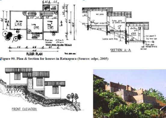
Resettlement of houses (Ratnapur, Sri Lanka)
The relocation sites being mid-risk areas and low-risk areas were selected by planners to relocate the homeless people. Special features were included during the design and construction phases to control soil erosion and earth slips. The features were as follows:
1) The roads were sited parallel to the contour lines.
2) The house designed in split levels minimizing disturbance to the hill slopes. Cutting and filling was hardly done except for a suitable amount of earth filling under the platforms. The concrete columns were embedded on the hardest layer (bedrock) for maximum stability.
3) Engineered retaining walls were used within the split levels and
4) Natural vegetation was retained to the maximum during site clearing.
The house had three levels that could be accessed by a continuous single flight stairway. The materials used was brick, reinforced concrete and stone. A stepped plan was conceived to integrate the house with the hills without interfering with the soil below.
For a Sustainable & Resilient Future
Here, the positive’s and negativities of examples explored from different countries are scrutinized and analyzed for each hazard outlined in detail in chapter 3. In each example, architects had made contributions in either the socio-cultural, physical, environmental aspects by hatching innovative ideas or concepts for implementation of sustainable homes or communities. These contributions are mostly apt in the “reconstruction phase” of the DM cycle in almost all the case studies chosen as “re-building” after destruction best fits the role of architects. Nonetheless, for further clarity of the dissertation research each example were exposed to the three main components of the DM cycle being pre-disaster situation, during/immediately after impact and post-disaster situation. This helps to give an overview as to where and why the architects are frequently needed and which of the following phases can accommodate the architect at best.
EARTHQUAKE
- The Great Hanshin/ Kobe Earthquake – 1995
- Individual houses to settlements (Hyogo, Kobe & surrounding areas)
ANALYSIS : Pros & Cons / Comments
Pre-disaster situation(Preparedness)
o No elaborate actions were taken during this phase for the examples shown.
During/ Immediately after impact(Response)
o Architects did not play a major role during this phase but the immediate necessities were provided for by other professionals in this case.
Post-disaster situation (Reconstruction & recovery)
o In the design of the temporary “blog house” considerations such a making this housing solution cheap, easy to assemble, and insulated in both summer and winter without sophisticated craftsmanship were all sustainable approaches.
o The cardboard tubes were factory made but the assembling was done by architects along with local participation involving the community in the process. Also, the houses can be modified or remodeled as required by the users. Extensions to the original “paper-house design” can be made in the extra parcel of land which reinforces the sense of belonging to the architectural solution and helps the occupants develop an identity of their own: two factors that govern a sustainable successful housing design.
o The units are easy to mantle and dismantle by a group of 4 people in 6 hours only while the materials can be easily recycled.
o The sensitive decision of using warm color and wood resembling materials on the outdoor and indoor of the units is strongly argued to give a “homey” feel. Also, the 6-feet wide space between houses is usable as a common area.
o The paper house architecture not only serves the purpose of providing temporary shelter but is more concrete in nature. The features of the housing units such as the operable roof, the shape and orientation, the planning- all could be retained but the materials can be modified in the sense that more robust but environment friendly materials can be used.
o The tubes can be made by casting concrete over it and reinforced by wire mesh (similar to the hollow post/ stump in Bangladesh), the rooms can be doubled henceforth and a miniature gardens (as in Haiti) can be incorporated for growing fruits and vegetables. Slowly, by considering the environment impact assessment of the houses and the types of materials used and the way it can function, decisions to convert temporary houses to permanent ones is a way forward towards sustainability.
- The Haiti Earthquake – 2010
- Urban city planning (Jacmel city)
ANALYSIS : Pros & Cons / Comments
Pre-disaster situation ( Preparedness)
o The field assessment reports performed by the architects along with volunteers, interns determined the unique characteristics of the site which is otherwise overlooked when random shelters are provided to counter the fast growing response to housing. Nonetheless, through this practice of going back to site every time for a solution in the master plan better prepared the architect as well as the community.
o The input from the beneficiaries was insightful and vice versa. This way the community is more educated and aware of what to do and how to cope for future calamities and also helps the experts to move forward with the reconstruction process.
During/ Immediately after impact(Response)
o Here, the response phase was entirely taken care of by other apt professionals as during this phase the immediate need for architects is slim. It is the later phase, as described below is where architects play the most significant role. Also, some selective works are undertaken by designers, planners and architects in the previous phase described above.
Post-disaster situation (Reconstruction & recovery)
o Jacmel was a land of opportunities being a World Heritage site and yet very vulnerable. It weakness was made its strength in this particular case.
o The revitalization pointed to the entire city rather than just a part of a community and its households. In this city, every household, every street, every corner and nook and the landscape is connected to one another. Hence, to maintain its characteristics culturally, ecologically and economically, the urban plan was layered into components to make every component function as one unit– a sustainable approach.
o The typologies and planning principles can be applied to any other designated satellite town development site as it’s replicable, affordable and functional. The methods are exemplary and can be successfully adapted to other locations.
o The master plan can be manipulated according to context keeping the vital components intact such as organization of the concepts but the housing types and materials can easily be different for other locations.
o Three important components were addressed, the houses and sanitary conditions; quick and long-term design and create settlements that fit the need of the people and generate income.
o In response to the demand of land and people, two components reforestation and agriculture was incorporated in the urban planning. This would provide the community with food supply, materials and as well add to the aesthetics of the city.
o The road networks connected a satellite city with the other developing cities in the future; with commercial and public zones; with the agriculture zones through layered road network for the ease of access and safety. Such planned routes can prove to be successful evacuation zones also.
o The houses maintain different typologies and are organized in different zones. The ones on the higher elevations are stepped or terraced and are protected from lateral forces but heavy concrete retaining walls. The timber panels may not be local but high quality material from Austria and are extremely stable and resistant to shaking, impervious to termites. Nonetheless, timber is being reproduced in the forest area nearby of similar quality.
o The pre-fabricated houses were brought in containers which were again recycled as building blocks for the popular light-industry in Haiti. Nothing was wasted.
o Each house follows the principles of self-sufficiency and social inter-connectivity which can be the back-bone for a socially sustainable settlement. Each house has a front porch and sometimes a convertible room that can function as a workshop on the street side and act as a social platform suiting Caribbean ways. The chunk of green plot on the back gives the residents ample food supply which can also be sold. The roofs ventilate each and every single room and are a storm-catcher as well.
o Jacmel is designed as such that each house unit would function as a self-sufficient unit and each neighborhood would be independently function and stay connected with the other neighborhoods in a balanced manner giving rise to a socially, ecologically ,economically and physically stable habitat.
CYCLONE/ HURRICANE/ TYPHOON
- Cyclone Aila – May 25th, 2009
- Disaster Resilient Habitat (Adarshagram, Sathkhira, Bangladesh)
ANALYSIS : Pros & Cons / Comments
Pre-disaster situation ( Preparedness)
o The site-visits, workshops and discussion sessions between the beneficiaries and the professionals helped the community to become more aware of the looming dangers and the surroundings. The constant exchange of ideas between two parties helped to prepare the designs according to the needs. The transparency in information transfer and skills and sharing of knowledge prepared the individuals and community to adopt the idea successfully.
o With the success in Adarshagram, two more communities decided to take up the initiative of building DRH. The participation of the community in identifying threats, mapping escape routes and helping to build homes prepared the community to believe in the project. This allowed a sense of belonging; induced skills into people which are transferred from community to community People came together to “build back better” their own through extensive preparation to be able to implement and realize their concept of “dream home”.
During/ Immediately after impact(Response)
o Architects had no role during this phase but the immediate necessities were provided for by other professionals in this case.
Post-disaster situation (Reconstruction & recovery)
o In DRH, every “home “was seen as “cyclone shelter” meaning that people had to no longer abandon their own lands to seek refuge somewhere else. This would retain the self- identity, dignity and the homes of the people.
o The cost of the disaster-resilient houses was much cheaper than building a cyclone shelter. All the materials used were local and the technique used could be easily replicated in other places unlike
a cyclone shelter that requires expert skills and is also not functional always during and post-disaster.
o The participation of people in the building process was a valuable resource, if not with money they helped out with their skills and labor. In the later phases, the locals monitored the quality of construction as well.
o Reconstruction should be an evolutionary process, hence there was never a pre-conceived design of the DRH, and in fact it evolved on site with time. The technical know-how in combination with local skills created a solution that was acceptable by all.
o The joineries of the foundation to the structure and the structure too the roof was carefully designed and implemented. However, materials (concrete, brick) had to be transported to the site by boat at high tide which was a risky business. Also, the detailing and connections need to be periodically monitored and maintained by the owners without having the feeling that such activities are a hassle.
o Timber was not used from the forests but from plantations and was replanted as sustainable approach.
o The construction of the roof was a bit elaborate as the local practices with “golpata” were not resilient enough and concrete roofs were expensive. Every tile had to be screwed on to the roof structure as clay tiles were the only available and sustainable material there. Such a process is labor-intensive and intricate but then again labor was the best resource that could be expended.
o The houses on stilts are faring well with the climate so far and are little used by the people except in adverse conditions. Instead extensions and modifications of the lower area and homestead is slowly becoming a continuous process making the community even more diverse and strong.
o Should sea-level rise, the houses on stilts would be useable but transportation will be possible only by boats. For food supply, saline resistant crops need to be grown. To eliminate the latter problems, the access paths need to be raised or elevated by means of water-resistant landscaping to work better. This maybe a scope for the project to evolve.
o The habitat had also brought about a change in the social fabric of the community in terms of unity, security, confidence and self-sufficiency. On the contrary, the flourished house-owners have lost their right to accept aid from agencies as they are better-off. This some people say is disadvantageous to them but in the long-run they get a self-sustaining, permanent habitat.
o DRH is an integrated and evolutionary approach. Further work on access routes, public facilities, landscaped features need to be addressed to make it even stronger. Such is the beauty of the project that as people become more conscious of the problems, more innovations will emerge and what started out from a single unit and a small village will spread out and be a catalyst for DRR and sustainability.
- Typhoon Xangsane– 2006
- Individual houses- Settlement planning (Da Nang Port City, Vietnam)
ANALYSIS : Pros & Cons / Comments
Pre-disaster situation ( Preparedness)
o Design competitions locally and internationally is a very effective way to come up with ideas for resilient designs. The potential entries were publicly displayed to educate the mass about the local context and the risk of living in vulnerable housing. This way a community is better prepared and aware of future disasters.
o Field visits were a means to gain knowledge and insight on the present housing settlement and housing typologies of the city.
During/ Immediately after impact(Response)
o Architects had no role during this phase but the immediate necessities were provided for by other professionals in this case.
Post-disaster situation (Reconstruction & recovery)
o The road network for the settlement was arranged in a zig- zag pattern and the houses followed along the pattern. This resulted in unequal positioning of houses and interesting notches and corners were created. With the high winds coming in, the corners, notches or turns serves to fragment wind flow and reduces wind effects pressed on buildings.
The rectangle and square shapes of the buildings is effective at reducing wind pressures. Si,ple, symmetrical shapes allows high winds to go around them easily so that it is distributed in different directions and not concentrated in one point.
o The house forms were appropriate to people’s lifestyles and community settings. The three different building typologies have windows in front and on the rear in one line which lets the wind pass through easily minimizing wind impact.
o The slanted roof of (type1-tube house)in front is made steep enough with appropriate angle to deviate the wind. The slanted roof on the rear side is offset from the first roof at a higher elevation and is dotted with louvers or openings sometimes called the “cyclone trap”. As high winds move through it, the speed is reduced and so is the impact on the building. Also, even if partition collapses, it can be easily replaced later without putting much stress on the structure.
FLOOD
- Annual Flooding- (Bangladesh)
- Individual houses- Homestead planning-Landscaping (Flood –prone areas, Bangladesh)
This analysis is done from an overall point of view of Bangladesh. Since, flood is common is nearly almost every part of Bangladesh, the interventions used is similar and hence the analysis is deemed to be similar for the entire country given the similar context.
ANALYSIS : Pros & Cons / Comments
Pre-disaster situation ( Preparedness)
o Communities were involved during the input of these innovative means which means it led the people to become more aware and educated about the flood situation. Also, the sharing of expert knowledge helped the locals to combine their own ideas and be creative with the solutions.
During/ Immediately after impact(Response)
o Hardly any actions are seen to be performed by architects, planners in this particular phase for flood.
Post-disaster situation (Reconstruction & recovery)
o Plinth stabilizing is one of the best ways to protect houses since the plinth cap which is about 2 to 3 inches thick holds the posts firmly in place. The soil below the cap is compacted and because of the cap prevents scour and movement of soil from underneath during prolonged periods of flood.
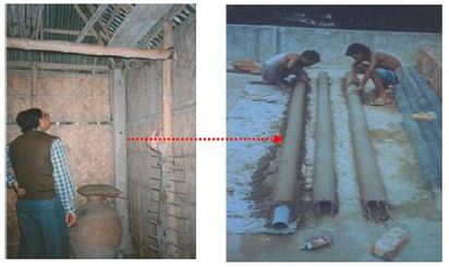
o The kaatla or concrete hollow stump is advantageous over solid stumps because it saves material cost by 10%. The hollow space is filled with inexpensive earth before placing in the ground and strength is not compromised. Bamboo need not be replaced continuously as the kaatla double sthe lifespan by protecting it. It is wise to paint the lower end with bitumen and place polythene the bottom of the post and kaatla top to prevent from damping or termite infestation.
The RC posts are popular but cannot be afforded by all. Hence, to make it more universal, the posts have been made hollow so to save materials and reduce cost. Also, it is light weight and is easy to handle and transport. It provides better handgrip because of it cylindrical shape and no corner chipping happens unlike the regular posts. In contrary, the production requires training and quality control and is difficult to make.
CEB’s can easily be made by local skills and can be constructed because of the irregular surface it possesses. The blocks interlock with each other so that walls have stronger bonds.
TSUNAMI
- Great East Japan Tohuku Earthquake come Tsunami – March 11th, 2011
- Urban Community Space Planning (Minami Sanriku)
ANALYSIS : Pros & Cons / Comments
Pre-disaster situation ( Preparedness)
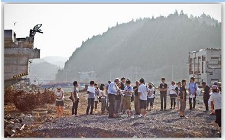
o The affected site was surveyed by architecture students through the 3/ll program (a part of the training workshop initiated by professors of MIT) helped to raise awareness among future architects as to how to build more sustainable structures for future calamities.
o A graduate spring studio course was also designed to educate young architects about the calamity. This kind of education where architects are taught and prepared to “rebuild” rather than “just build” gives birth to a socially conscious set of designers and planners. This will prove to be a basis for resilient and sustainable construction.
o A team is again expected to travel to the disaster affected site to build structures conceived during spring course. The exchange of ideas between the community-experts-students should enhance the implementation phase later in the cycle. Such kind of preparedness through education and awareness triggers better, safer and healthier planning and design.
During/Immediately after impact (Response)
o The post-disaster site was surveyed, SWOT analysis and rapid/damage assessment performed by student-teacher team of MIT. The team recorded information about debris, vegetation, soil, topography and other environmental features required for appropriate planning. No time was wasted during the documentation process and timely collection of basic data was achieved. Appropriate information about physical, social and economic damage was extracted.
o The findings were scrutinized later during a three-week long workshop and potential sites were suggested to the communities for future interventions. The initial assessment done by architects ensured that activities were to smooth and timely and collection was not overlapping or flawed.
Post-disaster situation (Reconstruction & recovery)
o The community centre helped to revitalize the community and brought back the sense of belongingness. It was a useful way of restoring the cultural and traditional values for the displaced individuals.
o The sites chosen for the temporary housing were at a safe distance from where the disaster had repeatedly struck time and again. People from different spaces had gathered after losing homes and livelihood and would live here for long until they could call a place their “home” again.
o Even though, the “community center” was built upon a “temporary housing”, it acted as a catalyst to build concrete solutions in the future as the idea was being accepted widely by the inhabitants and later by the civic leaders also.
o The injection of community spaces spurred interaction and collaboration between the residents over tea or chit-chat (a cultural practice of Japan) and enhanced it while the community.
With the community bonding revived and generation of income and activities underway; this idea could be made concrete by replacing the temporary houses with permanent ones. Also, since the polycarbonate roof and wooden deck of the centers were being replaced by even more robust materials such as cedar framing and stone base for deck; this site would easily be accepted by residents to build their permanent homes. The combination of both structural intervention (physical building) and non-structural intervention (psychological building) are key components of reconstruction and such was true in this case.
o An idea of an interesting “public space” in a small alleyway of temporary houses incorporated all the attributes needed for a “cluster” of people to function systematically and become a community. The acceptance of a temporary site; the interaction amongst strangers and participating as a community to build a structure of their own; the demand for activities to bring money–all were stimulated from such an idea of community center.
o Such spaces act as a hub that helps communities to rebuild resources that would not otherwise garner appropriate attention or support. These hubs help to diminish isolation, cultural gaps and homelessness after a disaster and later acts as resilient public spaces in which permanent solutions(such as housing) can be built on. These spaces double as resources and build safe, self-sustaining communities in the long run.
o The nest-like space impregnated the sense of “home” once again into the people to create a permanent habitat around it. This is a way forward towards sustainability.
Summary of Analysis
Through the analysis of different projects some “realized” and some “conceptualized” at home and away, it can be concluded that intervention techniques be it (structural or non-structural) is a way forward to the future. How? In the previous chapter, it can be seen that every project and every practice has been viewed as a “window of opportunity”. Every context is different and so is every disastrous situation. Hence, if every project is viewed in a positive light projecting towards the future, then sustainability and resilience can be achieved by evolving and molding ideas according to what the situation demands. In these case studies, likewise have been observed as ideas and concepts were presented that would cater to needs of the people and their surroundings and not visualized as only a mere project to respond to the immediate demands and needs only.
Every individual, every household, every nook and corner of the neighborhood that connect to the greater whole to form a community that would eventually expand to greater nations should be the matter of concern; not just an individual entity. Development activities should be a continuous process of tasks that should hatch a solution-“a robust-sustainable solution” and not just a “product”. Repetition of previous fixed set of concepts for housing solutions should be discarded and innovative concepts should be accepted and absorbed by the power leaders to the grass root levels. This should in turn, give rise to dynamism (especially in the preparedness and reconstruction sectors) in the activities of the DRMC and architectural practices rather than sticking to a stereo-typed nature of practice. Also, this should help to open up a completely new trend and style in architecture and produce a completely new set of architects who would learn to re-orient themselves in a different order, in a different manner and lead the way to a more humanitarian architecture.
That architecture and disaster management is overlapping, the previous chapter bears proof. It has been observed that people tend to abandon their homes, their shelters and eventually their lives because they fall prey to the system delivering “the hurried product”. The system often identifies survival to be the vital most need for humanity and yet it is addressed through temporary solutions that may not sustain in the long run. If apt professionals (such as architects and planners) were recognized in the reconstruction and preparedness phases, then a community ready for the future adversity would arise and it would solve un-coordinated and inappropriate planning usually performed by unspecialized and unaware task forces.
The overall idea is not to house an “entity” but an entire “habitat” that should comprise of the humans and the whole system around them. An idea that would solve problems in terms of social, cultural, environmental, economical and physical aspects- everything required to make a habitat stable and function as “one unit” and not just “one entity”. The ideas should be able to think “beyond shelter” and incorporate other elements around it. A house is a “home” when it can sustain itself on its own and this is only possible if everybody starts “re-building” rather than only building because rebuilding “builds back better homes to better lives”.
Conclusion
With the advent of civilization in terms of technology, lifestyle, economic growth, population expansion,and urbanization; the world has seen a series of dangerous events over the recent years. These events or more notoriously known as “natural hazards” expose countries, towns and villages; people, homes and their livelihoods to immense destruction causing loss of lives and property. Restoring and Reconstruction of such immense destruction can take ages or be completely unsuccessful if not managed well which is often the case of post-disaster scenes. The reconstruction works are speedy processes that follow a given set of fixed rules and typologies inappropriate to context and culture without the supervision or involvement of apt professionals. The “who” does “what” aspect should be clear within the system and the approach of activities need to be a continuous process and not just a hurried “product”. Once this process of interventions and techniques is explored by fitting professionals, an environment of sustainability and resilience will arise after any calamity and this laid the foundations to form the basis of thethesis research.
This thesis paper helps to gather the idea that “architects” and “architectural interventions” can contribute greatly to the resilience and sustainability of a community. It is expected of architects to realize people-oriented projects that are an amalgamation of architecture that responds to humanitarian beliefs as well deals with the technical issues and the environment. The restoration and the reconstruction phases being the crucial stage of the DM cycle follows through the fact that if a disaster (small to magnanimous in proportion)should take place, then the community should be resilient or prepared enough to fight the situation successfully and spring back to normalcy in a short period of time without much ado. A “community” and not just an “individual” should be able to contain and at the same time resist the effects of the calamity which would otherwise wreck terror and havoc amongst nations. This paper hence, sheds light on those exemplary works by architects that have made a significant contribution towards the society and had helped people/ can help to get back to their feet after a disaster.
The show-casing of innovative works and interventions from all over the world can act as a platform of a new set of emerging architects, designers and planners having the capacity to “build” ,“re-build” and most importantly “build back better” (BBB) resilient “homes” to “sustainable nations”. The global context is ever-changing due to climate change and urbanization and hence the dynamics of our surroundings have become rather unpredictable posing greater challenges to professionals. Just like the context is in a constant process of change and so is the disaster that is constantly evolving. Hence, this paper realizes the fact that mainstreaming of a certain profession or practice is a draw-back and that it should be able to change and evolve with time and open a window for architects and designers in the world DRM platform.
Since, the topic of architectural practice in DRMC is seldom discussed in literature or policy-making; this paper highlights the need for good architectural interventions for future sustainability of an individual and his home that will eventually extend to an entire community. The skills of an architect and her innovations are very much vital in the system and so the works done in the preparedness and reconstruction phases are highlighted in the case studies in this dissertation. Also, the case studies have been scrutinized in the final chapter and the strengths, weaknesses, opportunities and threats have been presented to generate a conceptual idea about the projects whether the designs were sustainable and resilient or not.The solutions outlined can re-orient the general thinking about architecture as a profession and the welcoming of such practices can lead the way to a renewed and newer world.
The innovative ways presented in the dissertation represents the architectural practice ina different light and introduces it as one of the most vital branches of the disaster management system. The urban system is a complex system that connects the community along with its different entities. A shelter alone or a physical attribute only is never the answer to a post-disaster reconstruction scheme but other integrated components such as economic, social, cultural, political and environmental elements also play along with it.The architects and interventions are viewed here as agents of “change” and development to an evolving context which is in turn should lead the way of sustainability and resilience. It is said that the architect only possesses enough knowledge as to how to structure the human habitat appropriately and can envision creative, transformative spaces that can evolve with the situation in demand. Through this research, it is realized that a “house” should not be viewed a separate entity but it should be given the attributes of a “home”, a place of identity, by connecting all the components holistically in an integrated, participatory approach through interventions. This not only targets the physical environment but the socio-cultural, environmental and economic elements as well. When these elements are improved through interventions during the preparedness and the post-disaster reconstruction phases, and not only restored temporarily, then resilience and sustainability can be said to be achieved as is the essence of this entire dissertation paper.
Recommendations
The reconstruction and preparedness phases in the disaster risk management cycle (DRMC) often overlook the “community” and the “designers” who bear the optimum skills and knowledge of re-building. This maybe because of bad governance, unethical, unprofessional bureaucratic approaches or just maybe because of the lack of awareness and understanding. However, the instillation of the concept of architectural innovations may solve the problem of un-coordinated and inappropriate housing solutions before and after a disaster. The idea of comprehensive, innovative design solutions need to be brought to attention of the GO’s ,NGO’s and people alike through projects that have been “realized” or “conceptualized” to be a successful example of sustainability and resilience.
The new interventions and solutions need to be introduced and accepted by the key professionals and administration in the disaster management system. This practice will not only highlight the profession of architects in a new light but also will improve the activities before and after the implementation process. The “build back better” principle can be achieved if solutions are provided by experts namely architects and planners who possess adequate knowledge about reconstruction and re-building and not just temporary restoration. This will result in development activities that will follow a process through trial and error and participation and the result shall be fruitful for the future thriving of communities from disasters.